Fine Art Print > Asia > Iran > Maps
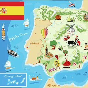
Fine Art Print : Map of the Moslem Empire, 750 AD, 1936


![]()
Fine Art Prints from Fine Art Finder
Map of the Moslem Empire, 750 AD, 1936
7125146 Map of the Moslem Empire, 750 AD, 1936; (add.info.: Map of the Moslem Empire, 750 AD. From A Short History of the World, published c.1936); Photo © Ken Welsh. All rights reserved 2024
Media ID 38432932
© © Ken Welsh. All rights reserved 2024 / Bridgeman Images
Ageing Iran Iranian Iranians Muslims Persia Persians Run Down Africa African African Egyptians Geographer
21"x14" (+3" Border) Fine Art Print
"Explore the vast expanse of the Moslem Empire in 750 AD with this stunning fine art print from our collection. This meticulously crafted reproduction, taken from a vintage map published in 1936, offers a unique glimpse into the historical boundaries and territories of this influential empire. Printed on high-quality paper, this beautiful piece is sure to be a striking addition to any room or office. Perfect for history buffs, collectors, and anyone who appreciates the beauty of vintage cartography."
21x14 image printed on 27x20 Fine Art Rag Paper with 3" (76mm) white border. Our Fine Art Prints are printed on 300gsm 100% acid free, PH neutral paper with archival properties. This printing method is used by museums and art collections to exhibit photographs and art reproductions.
Our fine art prints are high-quality prints made using a paper called Photo Rag. This 100% cotton rag fibre paper is known for its exceptional image sharpness, rich colors, and high level of detail, making it a popular choice for professional photographers and artists. Photo rag paper is our clear recommendation for a fine art paper print. If you can afford to spend more on a higher quality paper, then Photo Rag is our clear recommendation for a fine art paper print.
Estimated Image Size (if not cropped) is 53.3cm x 29.6cm (21" x 11.7")
Estimated Product Size is 68.6cm x 50.8cm (27" x 20")
These are individually made so all sizes are approximate
Artwork printed orientated as per the preview above, with landscape (horizontal) orientation to match the source image.
FEATURES IN THESE COLLECTIONS
> Fine Art Finder
> Artists
> Duncan McGregor Whyte
> Africa
> Egypt
> Related Images
> Asia
> Iran
> Related Images
> Maps and Charts
> Early Maps
> Maps and Charts
> Related Images
> Maps and Charts
> Spain
EDITORS COMMENTS
This print of the Map of the Moslem Empire, dating back to 750 AD, offers a glimpse into the rich history and expansive territories of the Islamic world during that era. The intricate details and aged appearance of this map evoke a sense of nostalgia for a bygone time when empires rose and fell in distant lands.
The faded colors and worn edges speak to the passage of time, reminding us that even great civilizations eventually fade into memory. From Egypt to Spain, Persia to North Africa, this map showcases the vast expanse of Muslim influence across continents and cultures.
As we study this historical artifact, we are transported back to a time when cartographers meticulously crafted maps by hand, capturing the essence of each region with precision and artistry. The engravings on this map tell stories of conquests, trade routes, and cultural exchanges that shaped the world as we know it today.
Through this lens into history, we gain a deeper understanding of how geography has played a crucial role in shaping human civilization. This Map of the Moslem Empire is not just an old piece of paper; it is a window into our collective past that continues to inspire curiosity and wonder about our shared heritage.
MADE IN THE USA
Safe Shipping with 30 Day Money Back Guarantee
FREE PERSONALISATION*
We are proud to offer a range of customisation features including Personalised Captions, Color Filters and Picture Zoom Tools
SECURE PAYMENTS
We happily accept a wide range of payment options so you can pay for the things you need in the way that is most convenient for you
* Options may vary by product and licensing agreement. Zoomed Pictures can be adjusted in the Cart.