Fine Art Print > Europe > United Kingdom > England > London > Museums > National Maritime Museum
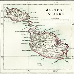
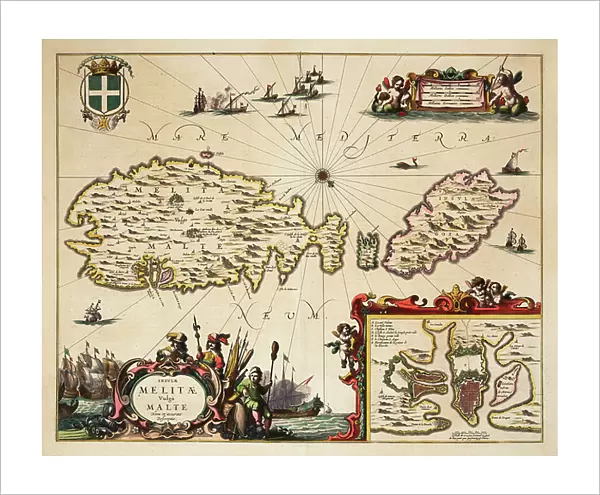
Fine Art Print : Map of Malta and Gozo, c.1650 (coloured engraving)
")

![]()
Fine Art Prints from Fine Art Finder
Map of Malta and Gozo, c.1650 (coloured engraving)
7339535 Map of Malta and Gozo, c.1650 (coloured engraving) by Unknown Artist, (17th century); 46x57 cm; National Maritime Museum, London, UK; (add.info.: Creator: unknown); © National Maritime Museum, Greenwich, London
Media ID 38177012
© © National Maritime Museum, Greenwich, London / Bridgeman Images
20"x16" (+3" Border) Fine Art Print
Transport yourself back in time with this stunning coloured engraving of a Map of Malta and Gozo from the 17th century. A unique piece of history for your walls.
20x16 image printed on 26x22 Fine Art Rag Paper with 3" (76mm) white border. Our Fine Art Prints are printed on 300gsm 100% acid free, PH neutral paper with archival properties. This printing method is used by museums and art collections to exhibit photographs and art reproductions.
Our fine art prints are high-quality prints made using a paper called Photo Rag. This 100% cotton rag fibre paper is known for its exceptional image sharpness, rich colors, and high level of detail, making it a popular choice for professional photographers and artists. Photo rag paper is our clear recommendation for a fine art paper print. If you can afford to spend more on a higher quality paper, then Photo Rag is our clear recommendation for a fine art paper print.
Estimated Image Size (if not cropped) is 50.2cm x 40.6cm (19.8" x 16")
Estimated Product Size is 66cm x 55.9cm (26" x 22")
These are individually made so all sizes are approximate
Artwork printed orientated as per the preview above, with landscape (horizontal) orientation to match the source image.
FEATURES IN THESE COLLECTIONS
> Fine Art Finder
> Artists
> Gerard van Keulen
> Fine Art Finder
> Artists
> Unknown Artist
> Europe
> Malta
> Related Images
> Europe
> United Kingdom
> England
> London
> Boroughs
> Greenwich
> Europe
> United Kingdom
> England
> London
> Museums
> Greenwich Heritage Centre
> Europe
> United Kingdom
> England
> London
> Museums
> National Maritime Museum
> Europe
> United Kingdom
> England
> London
> Towns
> Greenwich
> Europe
> United Kingdom
> Heritage Sites
> Maritime Greenwich
> Europe
> United Kingdom
> Maps
> Maps and Charts
> Early Maps
EDITORS COMMENTS
This stunning coloured engraving of a Map of Malta and Gozo from around 1650 transports us back in time to the 17th century, providing a glimpse into the intricate cartography of that era. The detailed map showcases the islands of Malta and Gozo in all their glory, with vibrant colours bringing each region to life.
Created by an unknown artist, this historical piece is now housed at the National Maritime Museum in London, UK. The careful craftsmanship and attention to detail evident in this map speak volumes about the skill and dedication of its creator.
As we study this map, we can imagine sailors using it as a guide on their voyages across the Mediterranean Sea. Each line and symbol tells a story of exploration and discovery, offering valuable insights into how these islands were perceived centuries ago.
Whether you have a personal connection to Malta or simply appreciate fine artistry, this print is sure to captivate your imagination. It serves as a reminder of our shared history and the importance of preserving such treasures for future generations to enjoy.
MADE IN THE USA
Safe Shipping with 30 Day Money Back Guarantee
FREE PERSONALISATION*
We are proud to offer a range of customisation features including Personalised Captions, Color Filters and Picture Zoom Tools
SECURE PAYMENTS
We happily accept a wide range of payment options so you can pay for the things you need in the way that is most convenient for you
* Options may vary by product and licensing agreement. Zoomed Pictures can be adjusted in the Cart.