Fine Art Print > Arts > Artists > M > Gerardus Mercator
Fine Art Print : Alsace, France (engraving, 1596)
")


![]()
Fine Art Prints from Fine Art Finder
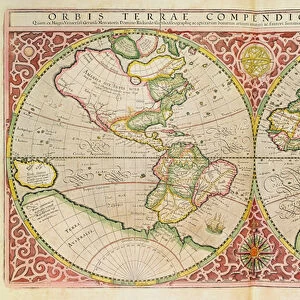
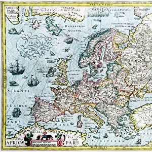
Alsace, France (engraving, 1596)
LRI4717918 Alsace, France (engraving, 1596) by Mercator, Gerardus (1512-94); Private Collection; (add.info.: Alsatia inferior, 1630: Alsace, south France - in " Atlas Ssive Corsmographicae Meditationes" by Gerard Mercator (Gerard de Kremer - Gerhard Kremer - Gerardus Mercator) (1512-1594), Duisburg 1596); Luisa Ricciarini; Flemish, out of copyright
Media ID 23718044
© Luisa Ricciarini / Bridgeman Images
Alsace Atlas Book Geographical Map
20"x16" (+3" Border) Fine Art Print
Step back in time with our exquisite Fine Art Print of Alsace, France by Luisa Ricciarini from Fine Art Finder. This captivating engraving, originally created by Gerardus Mercator in 1596, transports you to a bygone era with intricate details and rich history. Add an air of sophistication and timeless charm to your space with this stunning piece of art, perfect for collectors and history enthusiasts alike. Authentically reproduced from a private collection, this fine art print is a must-have for any discerning art lover.
20x16 image printed on 26x22 Fine Art Rag Paper with 3" (76mm) white border. Our Fine Art Prints are printed on 300gsm 100% acid free, PH neutral paper with archival properties. This printing method is used by museums and art collections to exhibit photographs and art reproductions.
Our fine art prints are high-quality prints made using a paper called Photo Rag. This 100% cotton rag fibre paper is known for its exceptional image sharpness, rich colors, and high level of detail, making it a popular choice for professional photographers and artists. Photo rag paper is our clear recommendation for a fine art paper print. If you can afford to spend more on a higher quality paper, then Photo Rag is our clear recommendation for a fine art paper print.
Estimated Image Size (if not cropped) is 48.1cm x 40.6cm (18.9" x 16")
Estimated Product Size is 66cm x 55.9cm (26" x 22")
These are individually made so all sizes are approximate
Artwork printed orientated as per the preview above, with landscape (horizontal) orientation to match the source image.
FEATURES IN THESE COLLECTIONS
> Fine Art Finder
> Artists
> Gerardus Mercator
> Arts
> Artists
> M
> Gerardus Mercator
> Maps and Charts
> Gerardus Mercator's Cartographic
> Maps and Charts
> Related Images
EDITORS COMMENTS
This print showcases an exquisite engraving of Alsace, France from the year 1596. Created by the renowned cartographer Gerardus Mercator, this detailed map offers a glimpse into the historical geography of Alsace during that era. The intricate lines and delicate shading bring to life the beauty and complexity of this region in southern France. The engraving is part of a private collection, carefully preserved to capture its timeless charm. It was originally featured in "Atlas Ssive Corsmographicae Meditationes" a significant work by Gerard Mercator published in Duisburg in 1596. This particular piece represents Alsatia inferior, providing valuable insights into the landscape and topography of Alsace at that time. Luisa Ricciarini has skillfully captured this remarkable artwork through her lens, allowing us to appreciate its artistic brilliance even more. With her keen eye for detail and composition, she brings out every intricacy present on the map. As we gaze upon this enchanting print, we are transported back in time to explore the rich history and cultural heritage of Alsace. It serves as a testament to both Mercator's exceptional craftsmanship as well as Ricciarini's talent for capturing art with precision. This print is not only visually stunning but also serves as a valuable educational resource for those interested in French geography or historical cartography. Its inclusion within Fine Art Finder ensures wider accessibility while preserving its significance for generations to come.
MADE IN THE USA
Safe Shipping with 30 Day Money Back Guarantee
FREE PERSONALISATION*
We are proud to offer a range of customisation features including Personalised Captions, Color Filters and Picture Zoom Tools
SECURE PAYMENTS
We happily accept a wide range of payment options so you can pay for the things you need in the way that is most convenient for you
* Options may vary by product and licensing agreement. Zoomed Pictures can be adjusted in the Cart.