Fine Art Print > Animals > Insects > Spiders > European Garden
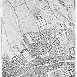
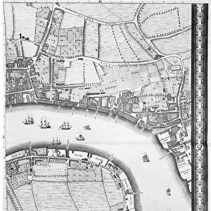
Fine Art Print : Map of Hounslow, Twickenham and Richmond, 1746 (coloured engraving)
")


![]()
Fine Art Prints from Fine Art Finder
Map of Hounslow, Twickenham and Richmond, 1746 (coloured engraving)
7340518 Map of Hounslow, Twickenham and Richmond, 1746 (coloured engraving) by Rocque, John (c.1704-d.1762); 51x67 cm; National Maritime Museum, London, UK; (add.info.: Creator: John Rocque
Sheet from An exact survey of the cities of London and Westminster, the Borough of Southwark, with the country near ten miles round'. John Rocque came to England as a child with his French Huguenot family. He was an estate surveyor and garden designer before he began mapping towns.); © National Maritime Museum, Greenwich, London
Media ID 38515556
© © National Maritime Museum, Greenwich, London / Bridgeman Images
20"x16" (+3" Border) Fine Art Print
Explore the rich history of West London with our Fine Art Prints from Media Storehouse! This stunning map, 'Map of Hounslow, Twickenham and Richmond', dated back to 1746 by renowned cartographer John Rocque, offers a unique glimpse into the region's past. Coloured in exquisite detail, this vintage engraving is now available as a high-quality print for you to treasure.
20x16 image printed on 26x22 Fine Art Rag Paper with 3" (76mm) white border. Our Fine Art Prints are printed on 300gsm 100% acid free, PH neutral paper with archival properties. This printing method is used by museums and art collections to exhibit photographs and art reproductions.
Our fine art prints are high-quality prints made using a paper called Photo Rag. This 100% cotton rag fibre paper is known for its exceptional image sharpness, rich colors, and high level of detail, making it a popular choice for professional photographers and artists. Photo rag paper is our clear recommendation for a fine art paper print. If you can afford to spend more on a higher quality paper, then Photo Rag is our clear recommendation for a fine art paper print.
Estimated Image Size (if not cropped) is 50.8cm x 40.6cm (20" x 16")
Estimated Product Size is 66cm x 55.9cm (26" x 22")
These are individually made so all sizes are approximate
Artwork printed orientated as per the preview above, with landscape (horizontal) orientation to match the source image.
FEATURES IN THESE COLLECTIONS
> Fine Art Finder
> Artists
> Greenvile Collins
> Fine Art Finder
> Artists
> John Rocque
> Animals
> Insects
> Spiders
> European Garden
> Arts
> Artists
> R
> John Rocque
> Europe
> Republic of Ireland
> Maps
> Europe
> United Kingdom
> England
> London
> Boroughs
> City of Westminster
> Europe
> United Kingdom
> England
> London
> Boroughs
> Greenwich
> Europe
> United Kingdom
> England
> London
> Boroughs
> Hounslow
> Europe
> United Kingdom
> England
> London
> Boroughs
> Related Images
> Europe
> United Kingdom
> England
> London
> Boroughs
> Southwark
> Europe
> United Kingdom
> England
> London
> Museums
> British Museum
EDITORS COMMENTS
This beautifully detailed coloured engraving from 1746 depicts a Map of Hounslow, Twickenham, and Richmond by the talented cartographer John Rocque. The intricate lines and vibrant colors bring to life the streets, rivers, and landmarks of these historic English towns in the 18th century.
John Rocque's expertise as an estate surveyor and garden designer is evident in this map, showcasing his meticulous attention to detail and skillful hand at mapping out urban landscapes. The map is part of his larger work titled 'An exact survey of the cities of London and Westminster, the Borough of Southwark, with the country near ten miles round', demonstrating his dedication to capturing every aspect of city life.
As you study this print closely, you can imagine what life was like in Hounslow, Twickenham, and Richmond during this period - bustling markets, grand estates, winding roads lined with trees. It serves as a window into history, allowing us to appreciate how these towns have evolved over time while preserving their unique charm.
This Map of Hounslow, Twickenham and Richmond is not just a geographical representation but a piece of art that captures the essence of 18th-century England. Display it proudly in your home or office as a reminder of our rich cultural heritage.
MADE IN THE USA
Safe Shipping with 30 Day Money Back Guarantee
FREE PERSONALISATION*
We are proud to offer a range of customisation features including Personalised Captions, Color Filters and Picture Zoom Tools
SECURE PAYMENTS
We happily accept a wide range of payment options so you can pay for the things you need in the way that is most convenient for you
* Options may vary by product and licensing agreement. Zoomed Pictures can be adjusted in the Cart.