Fine Art Print > Animals > Insects > Hemiptera > Black Scale
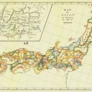
Fine Art Print : A chart of the trading part of the East Indies and China, with the adjacent islands, from Surrat to Japan, 1677 (print)
")


![]()
Fine Art Prints from Fine Art Finder
A chart of the trading part of the East Indies and China, with the adjacent islands, from Surrat to Japan, 1677 (print)
7340055 A chart of the trading part of the East Indies and China, with the adjacent islands, from Surrat to Japan, 1677 (print) by Seller, John (1632-97); 44.5x56 cm; National Maritime Museum, London, UK; (add.info.: Creator: John Seller; John Thornton; William Fisher; James Atkinson; John Colson
A chart from The English Pilot, the Third Book, describing... the Oriental Navigation'. John Seller went into partnership with Thornton, Fisher, Atkinson and Colson in 1677, so this chart must postdate the 1675 title-page of the volume. Shows English Pilot, East Indies & China. Scale: circa 1:11250000. Cartographic Note: Borders graduated for latitude. Bar scales in English and French leagues, Spanish leagues and Dutch miles. Contents Note: Japan is included as an inset.); © National Maritime Museum, Greenwich, London
Media ID 38515518
© © National Maritime Museum, Greenwich, London / Bridgeman Images
Chineze Islands Isles South East Asia Asiae Chineses
20"x16" (+3" Border) Fine Art Print
Step into history with our exquisite Fine Art Prints from Media Storehouse! This stunning piece, 'A chart of the trading part of the East Indies and China, with the adjacent islands, from Surrat to Japan', is a rare opportunity to own a historical map that dates back to 1677. Created by renowned cartographer John Seller in collaboration with Bridgeman Images from Fine Art Finder, this print offers an unparalleled glimpse into the trading routes of old. Perfect for art enthusiasts and history buffs alike, our prints are carefully curated to bring you closer to the past.
20x16 image printed on 26x22 Fine Art Rag Paper with 3" (76mm) white border. Our Fine Art Prints are printed on 300gsm 100% acid free, PH neutral paper with archival properties. This printing method is used by museums and art collections to exhibit photographs and art reproductions.
Our fine art prints are high-quality prints made using a paper called Photo Rag. This 100% cotton rag fibre paper is known for its exceptional image sharpness, rich colors, and high level of detail, making it a popular choice for professional photographers and artists. Photo rag paper is our clear recommendation for a fine art paper print. If you can afford to spend more on a higher quality paper, then Photo Rag is our clear recommendation for a fine art paper print.
Estimated Image Size (if not cropped) is 50.8cm x 40.6cm (20" x 16")
Estimated Product Size is 66cm x 55.9cm (26" x 22")
These are individually made so all sizes are approximate
Artwork printed orientated as per the preview above, with landscape (horizontal) orientation to match the source image.
FEATURES IN THESE COLLECTIONS
> Fine Art Finder
> Artists
> John Seller
> Animals
> Insects
> Hemiptera
> Black Scale
> Arts
> Artists
> A
> James Atkinson
> Arts
> Artists
> A
> John Atkinson
> Arts
> Artists
> A
> William Atkinson
> Arts
> Artists
> F
> William Fisher
> Arts
> Artists
> H
> James Holland
> Arts
> Artists
> J
> William James
> Arts
> Artists
> P
> William Page
> Arts
> Artists
> S
> John Seller
> Arts
> Artists
> W
> John White
EDITORS COMMENTS
This intricate and detailed chart of the trading part of the East Indies and China, with the adjacent islands, from Surrat to Japan, dating back to 1677, is a fascinating glimpse into the maritime history of that era. Created by John Seller in partnership with Thornton, Fisher, Atkinson, and Colson as part of 'The English Pilot', this map showcases the English navigation routes in Asia during the 17th century.
With borders graduated for latitude and bar scales in various measurements including English leagues and Dutch miles, this chart was an essential tool for sailors navigating through these treacherous waters. The inclusion of an inset featuring Japan adds another layer of detail to this already comprehensive map.
As we study this print today at the National Maritime Museum in London, we are transported back in time to an age when exploration and trade flourished across distant lands. The meticulous craftsmanship and attention to detail displayed on this map serve as a testament to the skill and dedication of cartographers during that period.
This print not only serves as a historical artifact but also as a work of art that captures the essence of early maritime navigation in Asia. It stands as a reminder of our enduring fascination with maps and exploration throughout history.
MADE IN THE USA
Safe Shipping with 30 Day Money Back Guarantee
FREE PERSONALISATION*
We are proud to offer a range of customisation features including Personalised Captions, Color Filters and Picture Zoom Tools
SECURE PAYMENTS
We happily accept a wide range of payment options so you can pay for the things you need in the way that is most convenient for you
* Options may vary by product and licensing agreement. Zoomed Pictures can be adjusted in the Cart.