Fine Art Print > Europe > Norway > Maps
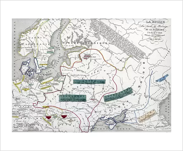
Fine Art Print : Barbarian invasions - Geographic map of Russia, Sweden, Norway and Denmark, with indications of the barbarians (goths, ostrogoths, visigoths, alains, huns) at the end of the 5th century (Map of Russia, Sweden)
 at the end of the 5th century (Map of Russia, Sweden)")

![]()
Fine Art Prints from Fine Art Finder
Barbarian invasions - Geographic map of Russia, Sweden, Norway and Denmark, with indications of the barbarians (goths, ostrogoths, visigoths, alains, huns) at the end of the 5th century (Map of Russia, Sweden)
ELD4924560 Barbarian invasions - Geographic map of Russia, Sweden, Norway and Denmark, with indications of the barbarians (goths, ostrogoths, visigoths, alains, huns) at the end of the 5th century (Map of Russia, Sweden, Norway and Denmark (indication of barbarians as huns, alans, Goths, Ostrogoths, Visigoths)) 5nd century BC) Engraving from " Atlas Universel" by Houze, 1851 Private collection; (add.info.: Barbarian invasions - Geographic map of Russia, Sweden, Norway and Denmark, with indications of the barbarians (goths, ostrogoths, visigoths, alains, huns) at the end of the 5th century (Map of Russia, Sweden, Norway and Denmark (indication of barbarians as huns, alans, Goths, Ostrogoths, Visigoths)) 5nd century BC) Engraving from " Atlas Universel" by Houze, 1851 Private collection); Photo © The Holbarn Archive
Media ID 38103176
© © The Holbarn Archive / Bridgeman Images
Atlas Book Norvege Norway Norway Norwegian Norwegian Norwegians Suede Sverige Sweden Geographical Map Isadora
20"x16" (+3" Border) Fine Art Print
Explore the tumultuous history of barbarian invasions with this captivating geographic map of Russia, Sweden, Norway, and Denmark. Featuring detailed indications of various tribes such as the Goths, Ostrogoths, Visigoths, Alains, and Huns at the end of the 5th century. A stunning Fine Art Print from Bridgeman Images available at Media Storehouse.
20x16 image printed on 26x22 Fine Art Rag Paper with 3" (76mm) white border. Our Fine Art Prints are printed on 300gsm 100% acid free, PH neutral paper with archival properties. This printing method is used by museums and art collections to exhibit photographs and art reproductions.
Our fine art prints are high-quality prints made using a paper called Photo Rag. This 100% cotton rag fibre paper is known for its exceptional image sharpness, rich colors, and high level of detail, making it a popular choice for professional photographers and artists. Photo rag paper is our clear recommendation for a fine art paper print. If you can afford to spend more on a higher quality paper, then Photo Rag is our clear recommendation for a fine art paper print.
Estimated Image Size (if not cropped) is 50.8cm x 36.4cm (20" x 14.3")
Estimated Product Size is 66cm x 55.9cm (26" x 22")
These are individually made so all sizes are approximate
Artwork printed orientated as per the preview above, with landscape (horizontal) orientation to match the source image.
FEATURES IN THESE COLLECTIONS
> Fine Art Finder
> Artists
> Raymond de la Neziere
> Europe
> Denmark
> Related Images
> Europe
> Norway
> Related Images
> Europe
> Sweden
> Related Images
EDITORS COMMENTS
This print showcases a geographic map of Russia, Sweden, Norway, and Denmark at the end of the 5th century, depicting the tumultuous period of Barbarian invasions. The intricate details on the map highlight the movements of various barbarian tribes such as the Goths, Ostrogoths, Visigoths, Alains, and Huns as they ravaged through these lands.
The visual representation offers a glimpse into the chaotic history of this era, where these fierce warriors clashed with established civilizations and left a trail of destruction in their wake. The strategic placement of each tribe on the map gives insight into their territorial expansion and conquests during this turbulent time.
As we study this historical artifact from ""Atlas Universel"" by Houze dating back to 1851, we are reminded of the relentless nature of these barbarian invasions and their lasting impact on European history. The precision in detailing each tribe's location serves as a reminder of how borders were constantly shifting due to these incursions.
This print from Fine Art Finder is not just a visual representation but also a window into an important chapter in human civilization. It invites us to reflect on how power dynamics have shaped our world throughout centuries and underscores the resilience of societies in facing external threats.
MADE IN THE USA
Safe Shipping with 30 Day Money Back Guarantee
FREE PERSONALISATION*
We are proud to offer a range of customisation features including Personalised Captions, Color Filters and Picture Zoom Tools
SECURE PAYMENTS
We happily accept a wide range of payment options so you can pay for the things you need in the way that is most convenient for you
* Options may vary by product and licensing agreement. Zoomed Pictures can be adjusted in the Cart.