Fine Art Print > Europe > Italy > Tuscany > Florence
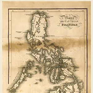
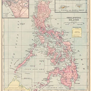
Fine Art Print : Map of the Philippines, from the Sala delle Carte Geografiche


![]()
Fine Art Prints from Fine Art Finder
Map of the Philippines, from the Sala delle Carte Geografiche
BEN95487 Map of the Philippines, from the Sala delle Carte Geografiche (Hall of Geographical Maps) c.1570 (oil on panel) by Danti, Egnazio (1536-86); Palazzo Vecchio (Palazzo della Signoria) Florence, Italy; Photo eRaffaello Bencini; Italian, out of copyright
Media ID 22909614
© Raffaello Bencini / Bridgeman Images
Borneo Cartouche Islands New Guinea South China Sea Sumatra
21"x14" (+3" Border) Fine Art Print
Discover the rich history and cultural beauty of the Philippines with our exquisite Map of the Philippines fine art print. This stunning reproduction is taken from the Sala delle Carte Geografiche, a renowned collection of geographical maps housed in Florence, Italy. Dated back to around 1570, this captivating map, created by the master cartographer Ignazio Danti, showcases the intricate details of the Philippine archipelago during the Renaissance era. Add an air of sophistication and worldly charm to your home or office with this beautiful and authentic work of art.
21x14 image printed on 27x20 Fine Art Rag Paper with 3" (76mm) white border. Our Fine Art Prints are printed on 300gsm 100% acid free, PH neutral paper with archival properties. This printing method is used by museums and art collections to exhibit photographs and art reproductions.
Our fine art prints are high-quality prints made using a paper called Photo Rag. This 100% cotton rag fibre paper is known for its exceptional image sharpness, rich colors, and high level of detail, making it a popular choice for professional photographers and artists. Photo rag paper is our clear recommendation for a fine art paper print. If you can afford to spend more on a higher quality paper, then Photo Rag is our clear recommendation for a fine art paper print.
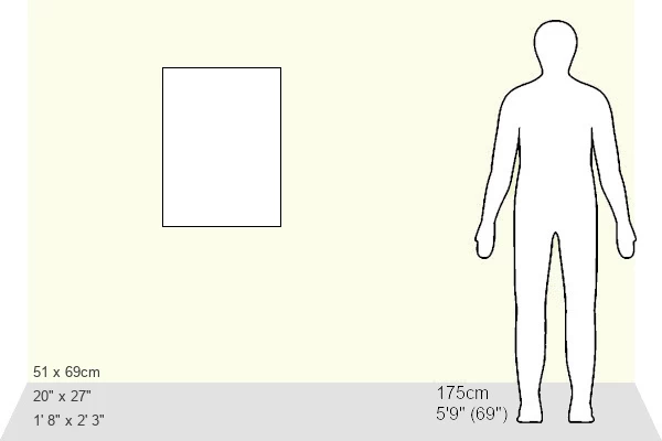
Estimated Image Size (if not cropped) is 31.1cm x 53.3cm (12.2" x 21")
Estimated Product Size is 50.8cm x 68.6cm (20" x 27")
These are individually made so all sizes are approximate
Artwork printed orientated as per the preview above, with portrait (vertical) orientation to match the source image.
FEATURES IN THESE COLLECTIONS
> Fine Art Finder
> Artists
> Egnazio Danti
> Fine Art Finder
> Artists
> Thomas Smythe
> Fine Art Finder
> Maps (celestial & Terrestrial)
> Asia
> Philippines
> Maps
> Asia
> Philippines
> Related Images
> Europe
> Italy
> Tuscany
> Florence
> Maps and Charts
> Italy
EDITORS COMMENTS
This print showcases the exquisite "Map of the Philippines" painted by Egnazio Danti in 1570. The artwork, located in the Sala delle Carte Geografiche (Hall of Geographical Maps) within Palazzo Vecchio, Florence, Italy, is a testament to Danti's mastery as a cartographer. The map itself is an oil painting on panel and offers a remarkable depiction of the Philippine archipelago during that era. With intricate details and vibrant colors, it presents not only the islands but also surrounding regions such as Borneo, Sumatra, and New Guinea. Its inclusion of geographical features like the South China Sea adds depth and context to this historical representation. One cannot help but be drawn to the elaborate cartouche adorning this masterpiece. It serves as both an ornamental element and a source of information about its creator and purpose. Through this map print, viewers are transported back in time to witness how early explorers perceived these lands. Captured with precision by photographer Raffaello Bencini, this image perfectly preserves every brushstroke and nuance found within Danti's original work. As an Italian treasure now out of copyright restrictions, it allows art enthusiasts worldwide to appreciate its beauty without limitations or commercial constraints. Whether you are fascinated by cartography or simply captivated by historical paintings, this print offers a glimpse into both artistic excellence and our ever-evolving understanding of geography throughout history.
MADE IN THE USA
Safe Shipping with 30 Day Money Back Guarantee
FREE PERSONALISATION*
We are proud to offer a range of customisation features including Personalised Captions, Color Filters and Picture Zoom Tools
SECURE PAYMENTS
We happily accept a wide range of payment options so you can pay for the things you need in the way that is most convenient for you
* Options may vary by product and licensing agreement. Zoomed Pictures can be adjusted in the Cart.