Fine Art Print > Asia > Georgia > Maps
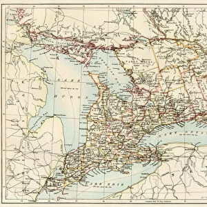
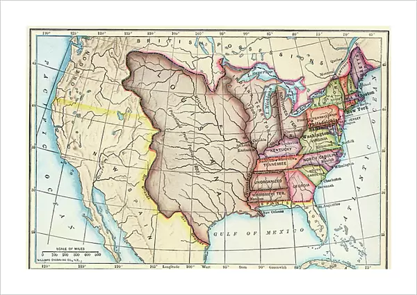
Fine Art Print : Map of the United States of 1803 showing the partition of the state (Kentucky, Tennessee, Georgia, Florida, Carolina, Virginia, Massachusetts, Indian territories, English Canada and Louisiana claimed by the French)
")

![]()
Fine Art Prints from Fine Art Finder
Map of the United States of 1803 showing the partition of the state (Kentucky, Tennessee, Georgia, Florida, Carolina, Virginia, Massachusetts, Indian territories, English Canada and Louisiana claimed by the French)
NWI4901249 Map of the United States of 1803 showing the partition of the state (Kentucky, Tennessee, Georgia, Florida, Carolina, Virginia, Massachusetts, Indian territories, English Canada and Louisiana claimed by the French). (Map of the United States in 1803, showing the Louisiana Purchase); (add.info.: Map of the United States of 1803 showing the partition of the state (Kentucky, Tennessee, Georgia, Florida, Carolina, Virginia, Massachusetts, Indian territories, English Canada and Louisiana claimed by the French). (Map of the United States in 1803, showing the Louisiana Purchase)); Photo © North Wind Pictures
Media ID 38100784
© © North Wind Pictures / Bridgeman Images
America Continent Canadians Etats Unis Etats Unis Usa United States Geographical Map
21"x14" (+3" Border) Fine Art Print
Explore the rich history of the United States with this stunning Fine Art Print depicting a detailed map from 1803. Perfect for adding a touch of vintage charm to any space.
21x14 image printed on 27x20 Fine Art Rag Paper with 3" (76mm) white border. Our Fine Art Prints are printed on 300gsm 100% acid free, PH neutral paper with archival properties. This printing method is used by museums and art collections to exhibit photographs and art reproductions.
Our fine art prints are high-quality prints made using a paper called Photo Rag. This 100% cotton rag fibre paper is known for its exceptional image sharpness, rich colors, and high level of detail, making it a popular choice for professional photographers and artists. Photo rag paper is our clear recommendation for a fine art paper print. If you can afford to spend more on a higher quality paper, then Photo Rag is our clear recommendation for a fine art paper print.
Estimated Image Size (if not cropped) is 53.3cm x 35.5cm (21" x 14")
Estimated Product Size is 68.6cm x 50.8cm (27" x 20")
These are individually made so all sizes are approximate
Artwork printed orientated as per the preview above, with landscape (horizontal) orientation to match the source image.
FEATURES IN THESE COLLECTIONS
> Fine Art Finder
> Artists
> Unknown Artist
> Asia
> Georgia
> Related Images
> Maps and Charts
> Early Maps
> North America
> Canada
> Maps
> North America
> Canada
> Related Images
> North America
> Related Images
EDITORS COMMENTS
This stunning print of a Map of the United States from 1803 offers a fascinating glimpse into the historical partitioning of states during that time period. From Kentucky to Florida, Carolina to Massachusetts, this map showcases the diverse territories that made up the young nation at the turn of the 19th century.
One can't help but be intrigued by the intricate details on display, including Indian territories and English Canada, as well as Louisiana claimed by the French. The Louisiana Purchase is prominently featured, highlighting one of America's most significant land acquisitions in history.
The vibrant colors and precise engraving bring this piece to life, offering viewers a chance to explore America's past in vivid detail. It serves as a reminder of how far our country has come since those early days, while also honoring the rich tapestry of cultures and regions that have shaped our national identity.
Whether you're a history buff or simply appreciate fine artistry, this Map of the United States from 1803 is sure to captivate and inspire all who gaze upon it.
MADE IN THE USA
Safe Shipping with 30 Day Money Back Guarantee
FREE PERSONALISATION*
We are proud to offer a range of customisation features including Personalised Captions, Color Filters and Picture Zoom Tools
SECURE PAYMENTS
We happily accept a wide range of payment options so you can pay for the things you need in the way that is most convenient for you
* Options may vary by product and licensing agreement. Zoomed Pictures can be adjusted in the Cart.