
Fine Art Print > Maps and Charts > Flat Earth
Fine Art Print : The "Anglo-Saxon" map of the World


![]()
Fine Art Prints from Fine Art Finder
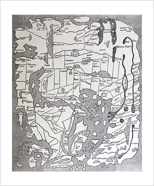
The "Anglo-Saxon" map of the World
1578436 The "Anglo-Saxon" map of the World; (add.info.: The "Anglo-Saxon" map of the World, drawn about 900 A.D.); Universal History Archive/UIG
Media ID 38310906
© Universal History Archive/UIG / Bridgeman Images
Anglo Saxon Explorers Flat Earth
20"x16" (+3" Border) Fine Art Print
Explore the intricate details of history with our Fine Art Print featuring "The 'Anglo-Saxon' map of the World" by Bridgeman Images. This ancient map, drawn around 900 A.D., offers a unique glimpse into early cartography and is sure to add a touch of historical charm to any space.
20x16 image printed on 26x22 Fine Art Rag Paper with 3" (76mm) white border. Our Fine Art Prints are printed on 300gsm 100% acid free, PH neutral paper with archival properties. This printing method is used by museums and art collections to exhibit photographs and art reproductions.
Our fine art prints are high-quality prints made using a paper called Photo Rag. This 100% cotton rag fibre paper is known for its exceptional image sharpness, rich colors, and high level of detail, making it a popular choice for professional photographers and artists. Photo rag paper is our clear recommendation for a fine art paper print. If you can afford to spend more on a higher quality paper, then Photo Rag is our clear recommendation for a fine art paper print.
Estimated Image Size (if not cropped) is 40.6cm x 49.3cm (16" x 19.4")
Estimated Product Size is 55.9cm x 66cm (22" x 26")
These are individually made so all sizes are approximate
Artwork printed orientated as per the preview above, with portrait (vertical) orientation to match the source image.
FEATURES IN THESE COLLECTIONS
> Fine Art Finder
> Temp Classification
> Maps and Charts
> Flat Earth
> Maps and Charts
> World
EDITORS COMMENTS
This fascinating print showcases the "Anglo-Saxon" map of the World, believed to have been drawn around 900 A.D. This ancient map provides a unique glimpse into the worldview of early explorers and cartographers, offering insights into how they perceived the world around them.
The intricate details and symbols on this map hint at the limited knowledge and understanding of geography during that time period. The concept of a flat earth is evident in this depiction, with landmasses depicted as interconnected islands surrounded by vast oceans.
As we marvel at this historical artifact, we are reminded of the courage and curiosity of those who ventured into uncharted territories in search of new lands and discoveries. The meticulous craftsmanship involved in creating such a detailed map without modern technology is truly impressive.
Through studying maps like these, we gain a deeper appreciation for the evolution of cartography and exploration over centuries. It serves as a reminder of how far we have come in our understanding of the world and inspires us to continue pushing boundaries in our quest for knowledge.
This print from Bridgeman Images captures not just an ancient map, but a piece of history that continues to intrigue and educate us about our past.
MADE IN THE USA
Safe Shipping with 30 Day Money Back Guarantee
FREE PERSONALISATION*
We are proud to offer a range of customisation features including Personalised Captions, Color Filters and Picture Zoom Tools
SECURE PAYMENTS
We happily accept a wide range of payment options so you can pay for the things you need in the way that is most convenient for you
* Options may vary by product and licensing agreement. Zoomed Pictures can be adjusted in the Cart.


