Fine Art Print > Europe > United Kingdom > England > Cambridge
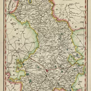
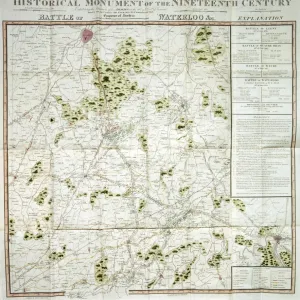
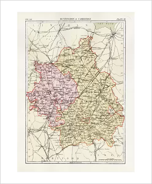
Fine Art Print : Huntingdon and Cambridge map 1881


![]()
Fine Art Prints from Fine Art Storehouse
Huntingdon and Cambridge map 1881
Encyclopedia Britannica 9th Edition Vol XII Philadelphia j.M. Stoddart & Co 1881
Unleash your creativity and transform your space into a visual masterpiece!
THEPALMER
Media ID 13611525
© This content is subject to copyright
Cambridge England Paper World Map Huntingdon
20"x16" (+3" Border) Fine Art Print
Step back in time with this exquisite fine art print of Huntingdon and Cambridge map from ThePalmer, published in the Encyclopedia Britannica 9th Edition in 1881 by J.M. Stoddart & Co in Philadelphia. This intricately detailed map offers a captivating glimpse into the history and geography of the region during the late 19th century. The vintage aesthetic and authentic cartography make this print an essential addition to any home or office, perfect for history enthusiasts, collectors, or those who appreciate the beauty of historical documents. Bring a piece of the past into your present with this beautiful fine art print from Media Storehouse.
20x16 image printed on 26x22 Fine Art Rag Paper with 3" (76mm) white border. Our Fine Art Prints are printed on 300gsm 100% acid free, PH neutral paper with archival properties. This printing method is used by museums and art collections to exhibit photographs and art reproductions.
Our fine art prints are high-quality prints made using a paper called Photo Rag. This 100% cotton rag fibre paper is known for its exceptional image sharpness, rich colors, and high level of detail, making it a popular choice for professional photographers and artists. Photo rag paper is our clear recommendation for a fine art paper print. If you can afford to spend more on a higher quality paper, then Photo Rag is our clear recommendation for a fine art paper print.
Estimated Image Size (if not cropped) is 37.2cm x 50.8cm (14.6" x 20")
Estimated Product Size is 55.9cm x 66cm (22" x 26")
These are individually made so all sizes are approximate
Artwork printed orientated as per the preview above, with portrait (vertical) orientation to match the source image.
FEATURES IN THESE COLLECTIONS
> Europe
> United Kingdom
> England
> Cambridge
> Europe
> United Kingdom
> England
> Maps
> Europe
> United Kingdom
> England
> Posters
> Maps and Charts
> Related Images
> Maps and Charts
> World
> North America
> United States of America
> Maps
> Fine Art Storehouse
> The Magical World of Illustration
> Palmer Illustrated Collection
> Fine Art Storehouse
> Map
> Historical Maps
> Fine Art Storehouse
> Map
> USA Maps
EDITORS COMMENTS
This print takes us back in time to the year 1881, when cartography was a meticulous art form. The image showcases a beautifully detailed map titled "Huntingdon and Cambridge" extracted from the Encyclopedia Britannica's 9th Edition Volume XII. Crafted by J. M. Stoddart & Co in Philadelphia, this antique piece of paper holds immense historical value. The map itself is an exquisite example of engraving, displaying intricate lines and delicate illustrations that bring to life the physical geography of Huntingdon and Cambridge in England. As we gaze upon it, we are transported to a world where exploration was still unfolding, and maps were essential tools for understanding our surroundings. The choice to capture this particular section of the world on such an elaborate map speaks volumes about its significance during that era. It serves as a reminder of how cartographers painstakingly crafted these works of art with precision and dedication. "ThePALMER" has skillfully preserved this remarkable piece through photography, allowing us to appreciate its beauty even today. This vertical composition invites us to delve into history while admiring the fine details etched onto the aged paper. Whether you're an enthusiast fascinated by old-world charm or someone intrigued by geographical evolution, this print is sure to captivate your imagination and transport you back in time.
MADE IN THE USA
Safe Shipping with 30 Day Money Back Guarantee
FREE PERSONALISATION*
We are proud to offer a range of customisation features including Personalised Captions, Color Filters and Picture Zoom Tools
SECURE PAYMENTS
We happily accept a wide range of payment options so you can pay for the things you need in the way that is most convenient for you
* Options may vary by product and licensing agreement. Zoomed Pictures can be adjusted in the Cart.