Fine Art Print > Maps and Charts > Americas
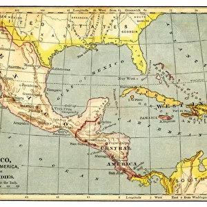
Fine Art Print : Mexico and West indies map 1875


![]()
Fine Art Prints from Fine Art Storehouse
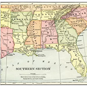
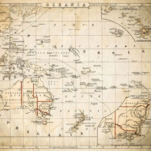
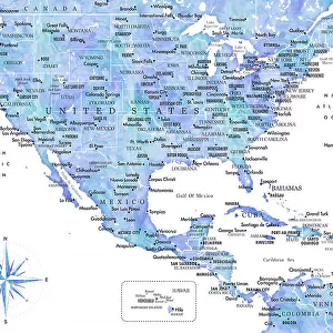
Mexico and West indies map 1875
The Independent Course Comprehensive Geography by James Monteith, A.S. Barnes & Co, New York & Chicago 1875
Unleash your creativity and transform your space into a visual masterpiece!
THEPALMER
Media ID 13612169
© This content is subject to copyright
Antilles Caribbean Central America Cuba Dominican Republic Globe Navigational Equipment Honduras Mexico Nicaragua Panama Paper Puerto Rico West Indies
20"x16" (+3" Border) Fine Art Print
Transport yourself back in time with this exquisite Fine Art Print from Media Storehouse. Featuring an intricately detailed map of Mexico and the West Indies, as originally published in "The Independent Course in Geography" by James Monteith in 1875. Meticulously reproduced from the vintage atlas by THEPALMER, this print showcases the historical cartography of the region during a fascinating period in history. Adorn your walls with this captivating piece and let the rich history of Mexico and the West Indies come to life in your home or office.
20x16 image printed on 26x22 Fine Art Rag Paper with 3" (76mm) white border. Our Fine Art Prints are printed on 300gsm 100% acid free, PH neutral paper with archival properties. This printing method is used by museums and art collections to exhibit photographs and art reproductions.
Our fine art prints are high-quality prints made using a paper called Photo Rag. This 100% cotton rag fibre paper is known for its exceptional image sharpness, rich colors, and high level of detail, making it a popular choice for professional photographers and artists. Photo rag paper is our clear recommendation for a fine art paper print. If you can afford to spend more on a higher quality paper, then Photo Rag is our clear recommendation for a fine art paper print.
Estimated Image Size (if not cropped) is 50.8cm x 40.6cm (20" x 16")
Estimated Product Size is 66cm x 55.9cm (26" x 22")
These are individually made so all sizes are approximate
Artwork printed orientated as per the preview above, with landscape (horizontal) orientation to match the source image.
FEATURES IN THESE COLLECTIONS
> Maps and Charts
> Related Images
> North America
> Cuba
> Maps
> North America
> Cuba
> Related Images
> North America
> Dominican Republic
> Maps
> North America
> Dominican Republic
> Related Images
> North America
> Honduras
> Maps
> North America
> Honduras
> Related Images
> North America
> Mexico
> Related Images
> North America
> Nicaragua
> Maps
> Fine Art Storehouse
> The Magical World of Illustration
> Palmer Illustrated Collection
> Fine Art Storehouse
> Map
> Historical Maps
> Fine Art Storehouse
> Map
> USA Maps
EDITORS COMMENTS
This print takes us back in time to the year 1875, where we can explore the intricate details of a map titled "Mexico and West Indies". The map is featured in James Monteith's renowned book, "The Independent Course Comprehensive Geography" published by A. S. Barnes & Co in New York and Chicago. As we gaze upon this historical artifact, our eyes are immediately drawn to the vibrant colors that adorn the countries and islands depicted. From Antillas to Cuba, from Puerto Rico to Honduras, every corner of this region is meticulously illustrated with precision and care. The etching technique used in creating this masterpiece adds an air of antiquity and charm. Each line engraved on paper tells a story of exploration and discovery during a time when cartography was at its peak. With its horizontal orientation, this map invites us to embark on a visual journey through Central America and the Caribbean. It serves as a reminder of how nature has shaped these lands over centuries - from majestic mountains to winding rivers - all captured within this single image. "The Mexico and West Indies Map 1875" transports us back in time while simultaneously reminding us of the enduring beauty found within these regions today. This remarkable piece by THEPALMER offers both history enthusiasts and admirers of fine art an opportunity to appreciate the intricacies of physical geography through an enchanting lens.
MADE IN THE USA
Safe Shipping with 30 Day Money Back Guarantee
FREE PERSONALISATION*
We are proud to offer a range of customisation features including Personalised Captions, Color Filters and Picture Zoom Tools
SECURE PAYMENTS
We happily accept a wide range of payment options so you can pay for the things you need in the way that is most convenient for you
* Options may vary by product and licensing agreement. Zoomed Pictures can be adjusted in the Cart.