Fine Art Print > Africa > Egypt > Maps
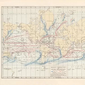
Fine Art Print : Antique map of Suez Canal, Egypt, 1880s, 19th Century


![]()
Fine Art Prints from Fine Art Storehouse
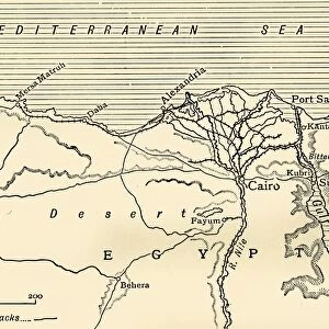
Antique map of Suez Canal, Egypt, 1880s, 19th Century
Vintage engraving of Antique map of Suez Canal, Egypt, 1880s, 19th Century. The Suez Canal is a sea-level waterway in Egypt, connecting the Mediterranean Sea to the Red Sea through the Isthmus of Suez
Unleash your creativity and transform your space into a visual masterpiece!
duncan1890
Media ID 19684343
© of Duncan P Walker
20"x16" (+3" Border) Fine Art Print
Step back in time with our exquisite Fine Art Print of an Antique Map of the Suez Canal from the 1880s. This stunning 19th-century engraving by duncan1890 transports you to a bygone era, showcasing the historical significance of the Suez Canal in Egypt. Add an air of sophistication and intrigue to your space with this vintage representation of maritime history.
20x16 image printed on 26x22 Fine Art Rag Paper with 3" (76mm) white border. Our Fine Art Prints are printed on 300gsm 100% acid free, PH neutral paper with archival properties. This printing method is used by museums and art collections to exhibit photographs and art reproductions.
Our fine art prints are high-quality prints made using a paper called Photo Rag. This 100% cotton rag fibre paper is known for its exceptional image sharpness, rich colors, and high level of detail, making it a popular choice for professional photographers and artists. Photo rag paper is our clear recommendation for a fine art paper print. If you can afford to spend more on a higher quality paper, then Photo Rag is our clear recommendation for a fine art paper print.
Estimated Image Size (if not cropped) is 40.6cm x 50.8cm (16" x 20")
Estimated Product Size is 55.9cm x 66cm (22" x 26")
These are individually made so all sizes are approximate
Artwork printed orientated as per the preview above, with portrait (vertical) orientation to match the source image.
FEATURES IN THESE COLLECTIONS
> Africa
> Egypt
> Related Images
> Maps and Charts
> Related Images
> Fine Art Storehouse
> Map
> Historical Maps
EDITORS COMMENTS
This print showcases an exquisite antique map of the Suez Canal, Egypt, dating back to the 1880s. A true relic from the 19th century, this vintage engraving beautifully captures the intricate details and historical significance of this remarkable waterway. The Suez Canal itself is a sea-level passage located in Egypt, serving as a vital link between the Mediterranean Sea and the Red Sea through the Isthmus of Suez. As we gaze upon this stunning piece of art, we are transported back in time to an era where exploration and trade routes shaped our world. The delicate lines and meticulous craftsmanship on display here highlight not only the technical prowess of cartographers during that period but also their deep understanding of geography. The Suez Canal has played a pivotal role in global commerce for centuries, facilitating international trade by providing ships with a direct route between Europe and Asia. This antique map serves as a testament to human ingenuity and determination to conquer nature's obstacles. With its warm sepia tones and aged appearance, this print evokes nostalgia while reminding us of how far we have come since its creation. It stands as both a work of art and an important historical document that allows us to appreciate the past while contemplating our future journeys through these iconic waters.
MADE IN THE USA
Safe Shipping with 30 Day Money Back Guarantee
FREE PERSONALISATION*
We are proud to offer a range of customisation features including Personalised Captions, Color Filters and Picture Zoom Tools
SECURE PAYMENTS
We happily accept a wide range of payment options so you can pay for the things you need in the way that is most convenient for you
* Options may vary by product and licensing agreement. Zoomed Pictures can be adjusted in the Cart.