Fine Art Print > Europe > Hungary > Maps
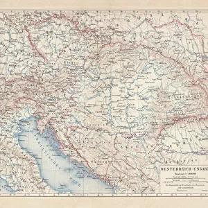
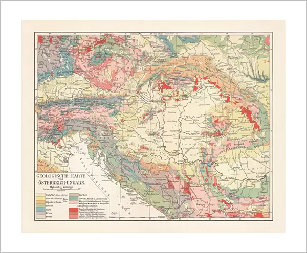
Fine Art Print : Geological map of the Austro-Hungarian Empire, lithograph, published in 1897


![]()
Fine Art Prints from Fine Art Storehouse
Geological map of the Austro-Hungarian Empire, lithograph, published in 1897
Geological map of the Austro-Hungarian Empire. Lithograph, published in 1897
Unleash your creativity and transform your space into a visual masterpiece!
ZU_09
Media ID 18292217
20"x16" (+3" Border) Fine Art Print
Step back in time with our exquisite Geological Map of the Austro-Hungarian Empire print from the Fine Art Storehouse. This stunning lithograph, published in 1897 by ZU_09, offers a captivating glimpse into the geological history of a bygone era. The intricate details of the map's terrain and geological formations transport you to a time when the Austro-Hungarian Empire ruled Europe. A must-have for history buffs, geology enthusiasts, and anyone seeking a touch of vintage charm for their home or office decor.
20x16 image printed on 26x22 Fine Art Rag Paper with 3" (76mm) white border. Our Fine Art Prints are printed on 300gsm 100% acid free, PH neutral paper with archival properties. This printing method is used by museums and art collections to exhibit photographs and art reproductions.
Our fine art prints are high-quality prints made using a paper called Photo Rag. This 100% cotton rag fibre paper is known for its exceptional image sharpness, rich colors, and high level of detail, making it a popular choice for professional photographers and artists. Photo rag paper is our clear recommendation for a fine art paper print. If you can afford to spend more on a higher quality paper, then Photo Rag is our clear recommendation for a fine art paper print.
Estimated Image Size (if not cropped) is 50.2cm x 40.6cm (19.8" x 16")
Estimated Product Size is 66cm x 55.9cm (26" x 22")
These are individually made so all sizes are approximate
Artwork printed orientated as per the preview above, with landscape (horizontal) orientation to match the source image.
FEATURES IN THESE COLLECTIONS
> Europe
> Hungary
> Related Images
> Maps and Charts
> Geological Map
> Maps and Charts
> Related Images
> Fine Art Storehouse
> Map
> Historical Maps
EDITORS COMMENTS
This lithograph, titled "Geological map of the Austro-Hungarian Empire" takes us on a journey back in time to the late 19th century. Published in 1897, this intricate print offers a visual representation of the geological landscape that once defined this vast empire. Created by ZU_09, an artist whose attention to detail is evident in every stroke and contour, this piece showcases both scientific accuracy and artistic finesse. As we delve into the depths of this lithograph, we are transported across borders and through diverse terrains. The map reveals a tapestry of colors and patterns that symbolize various rock formations, mineral deposits, and geographical features unique to each region within the Austro-Hungarian Empire. From towering mountain ranges to meandering rivers and fertile plains, every inch of land is meticulously documented with precision. Beyond its scientific value lies an aesthetic appeal that captivates our imagination. The delicate lines crisscrossing the paper create an intricate web connecting different parts of this vast empire. Each stroke seems purposeful yet graceful as it guides our eyes from one area to another. This lithograph serves as a testament to not only the geological richness but also the historical significance of the Austro-Hungarian Empire during its zenith. It reminds us that beneath our feet lie stories untold – tales carved by nature's forces over millennia. Whether you are a geology enthusiast or simply appreciate fine artistry, this print invites you to explore history through a lens
MADE IN THE USA
Safe Shipping with 30 Day Money Back Guarantee
FREE PERSONALISATION*
We are proud to offer a range of customisation features including Personalised Captions, Color Filters and Picture Zoom Tools
SECURE PAYMENTS
We happily accept a wide range of payment options so you can pay for the things you need in the way that is most convenient for you
* Options may vary by product and licensing agreement. Zoomed Pictures can be adjusted in the Cart.