Fine Art Print > Arts > Landscape paintings > Waterfall and river artworks > River artworks
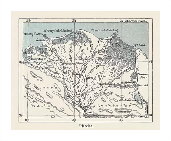
Fine Art Print : Historical map of the Nile Delta, Egypt, lithograph, published 1893


![]()
Fine Art Prints from Fine Art Storehouse
Historical map of the Nile Delta, Egypt, lithograph, published 1893
Historical map of the Nile Delta in Egypt - one of the world's largest river deltas - from Alexandria in the west to Port Said in the east, it covers 240 km (150 mi) of Mediterranean coastline. The Delta begins down-river from Cairo and is approximately 160 km (99 mi) long from north to south. Designations in German. Lithograph, published in 1893
Unleash your creativity and transform your space into a visual masterpiece!
ZU_09
Media ID 35842580
20"x16" (+3" Border) Fine Art Print
Step back in time with our exquisite Historical Map of the Nile Delta from Fine Art Storehouse. This stunning lithograph, published in 1893 by ZU_09, offers a captivating glimpse into the past. Covering over 240 km (150 mi) of Egypt's Mediterranean coastline from Alexandria to Port Said, this fine art print showcases the rich history and complexity of one of the world's largest river deltas. Add an air of sophistication and historical depth to any room with this intricately detailed and beautifully preserved piece of cartographic history.
20x16 image printed on 26x22 Fine Art Rag Paper with 3" (76mm) white border. Our Fine Art Prints are printed on 300gsm 100% acid free, PH neutral paper with archival properties. This printing method is used by museums and art collections to exhibit photographs and art reproductions.
Our fine art prints are high-quality prints made using a paper called Photo Rag. This 100% cotton rag fibre paper is known for its exceptional image sharpness, rich colors, and high level of detail, making it a popular choice for professional photographers and artists. Photo rag paper is our clear recommendation for a fine art paper print. If you can afford to spend more on a higher quality paper, then Photo Rag is our clear recommendation for a fine art paper print.
Estimated Image Size (if not cropped) is 50.8cm x 40.6cm (20" x 16")
Estimated Product Size is 66cm x 55.9cm (26" x 22")
These are individually made so all sizes are approximate
Artwork printed orientated as per the preview above, with landscape (horizontal) orientation to match the source image.
FEATURES IN THESE COLLECTIONS
> Africa
> Egypt
> Alexandria
> Africa
> Egypt
> Related Images
> Arts
> Landscape paintings
> Waterfall and river artworks
> River artworks
> Maps and Charts
> Early Maps
> Fine Art Storehouse
> Map
> Historical Maps
EDITORS COMMENTS
This historical map print depicts the Nile Delta in Egypt, one of the world's largest river deltas, as it appeared in 1893. Stretching along the Mediterranean coastline for approximately 240 km (150 mi) from Alexandria in the west to Port Said in the east, the Delta begins its expansive reach downriver from Cairo. The map covers an area of approximately 160 km (99 mi) from north to south. The intricate details of this lithograph reveal the complex network of the Nile River and its distributaries, which have shaped the fertile land of the Delta over thousands of years. The map is titled "Karte des Nildeltas in Aegypten" in German, which translates to "Map of the Nile Delta in Egypt." Published in 1893, this map offers a glimpse into the geography of Egypt during a significant period in its history. The Nile Delta has been a vital region for ancient civilizations, including the Pharaohs, and remains an essential agricultural and economic center for Egypt today. This historical map print is a testament to the enduring significance of the Nile Delta and its rich history. The intricate details of the map are brought to life through the lithographic printing process, which allows for precise and detailed reproductions. The use of subtle shading and tonal variations adds depth and texture to the map, making it a captivating piece of historical cartography. This map print is not only a valuable addition to any collection of historical maps or geographical prints but also a beautiful decorative piece that showcases the rich history and cultural significance of the Nile Delta in Egypt.
MADE IN THE USA
Safe Shipping with 30 Day Money Back Guarantee
FREE PERSONALISATION*
We are proud to offer a range of customisation features including Personalised Captions, Color Filters and Picture Zoom Tools
SECURE PAYMENTS
We happily accept a wide range of payment options so you can pay for the things you need in the way that is most convenient for you
* Options may vary by product and licensing agreement. Zoomed Pictures can be adjusted in the Cart.