Fine Art Print > North America > United States of America > New York > New York > Maps
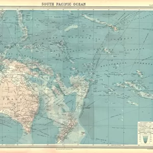
Fine Art Print : Map of Australia 1895


![]()
Fine Art Prints from Fine Art Storehouse
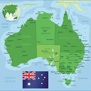
Map of Australia 1895
The Rand-McNally Grammar School Geography 1895 - Chicago & New York
Unleash your creativity and transform your space into a visual masterpiece!
THEPALMER
Media ID 14824643
© This content is subject to copyright
Australasia Australia Indonesia Malaysia New Zealand Oceania Pacific Papua Solomon Tasmania
20"x16" (+3" Border) Fine Art Print
Discover the rich history of cartography with our exquisite Fine Art Print of "Map of Australia 1895" by THEPALMER from the Media Storehouse collection. This captivating piece is taken from the Rand-McNally Grammar School Geography published in 1895, Chicago & New York. With intricate detail and vibrant colors, this fine art print brings the past to life, making it a stunning addition to any home or office. Travel back in time and adorn your walls with a piece of cartographic history.
20x16 image printed on 26x22 Fine Art Rag Paper with 3" (76mm) white border. Our Fine Art Prints are printed on 300gsm 100% acid free, PH neutral paper with archival properties. This printing method is used by museums and art collections to exhibit photographs and art reproductions.
Our fine art prints are high-quality prints made using a paper called Photo Rag. This 100% cotton rag fibre paper is known for its exceptional image sharpness, rich colors, and high level of detail, making it a popular choice for professional photographers and artists. Photo rag paper is our clear recommendation for a fine art paper print. If you can afford to spend more on a higher quality paper, then Photo Rag is our clear recommendation for a fine art paper print.
Estimated Image Size (if not cropped) is 44.9cm x 40.6cm (17.7" x 16")
Estimated Product Size is 66cm x 55.9cm (26" x 22")
These are individually made so all sizes are approximate
Artwork printed orientated as per the preview above, with landscape (horizontal) orientation to match the source image.
FEATURES IN THESE COLLECTIONS
> Asia
> Indonesia
> Related Images
> Asia
> Malaysia
> Related Images
> Maps and Charts
> Related Images
> North America
> United States of America
> New York
> New York
> Maps
> North America
> United States of America
> New York
> Related Images
> Oceania
> Australia
> Related Images
> Fine Art Storehouse
> Map
> Historical Maps
EDITORS COMMENTS
This print titled "Map of Australia 1895" takes us on a journey back in time to the late 19th century. The map, sourced from "The Rand-McNally Grammar School Geography 1895 - Chicago & New York" showcases the intricate details and craftsmanship that went into cartography during this era. As we gaze upon this vintage piece, we are transported to an age when exploration and discovery were at their peak. The map encompasses not only the vast continent of Australia but also highlights neighboring regions such as Malaysia, Tasmania, Australasia, Indonesia, New Zealand, Oceania, Pacific Islands including Papua and Solomon. The fine art print by THEPALMER captures every minute detail with precision and elegance. Each contour line and geographical feature is meticulously depicted using rich colors that bring life to the paper. This artwork serves as a testament to both historical accuracy and artistic expression. Beyond its aesthetic appeal lies a deeper appreciation for the significance of maps in shaping our understanding of the world. It reminds us of how boundaries have evolved over time while showcasing Australia's unique position within Oceania. Whether displayed in a classroom or home setting, this print invites viewers to immerse themselves in history while appreciating the beauty found within old-world cartography. THEPALMER's work truly encapsulates the essence of this remarkable period in geography's evolution.
MADE IN THE USA
Safe Shipping with 30 Day Money Back Guarantee
FREE PERSONALISATION*
We are proud to offer a range of customisation features including Personalised Captions, Color Filters and Picture Zoom Tools
SECURE PAYMENTS
We happily accept a wide range of payment options so you can pay for the things you need in the way that is most convenient for you
* Options may vary by product and licensing agreement. Zoomed Pictures can be adjusted in the Cart.