Fine Art Print > North America > United States of America > New York > New York > Maps
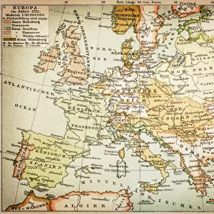
Fine Art Print : Map of Europe 1875


![]()
Fine Art Prints from Fine Art Storehouse
Map of Europe 1875
Elementary Geography Course by William Swinton - New York 1875
Unleash your creativity and transform your space into a visual masterpiece!
THEPALMER
Media ID 19834497
© 2014 Roberto Adrian Photography
20"x16" (+3" Border) Fine Art Print
Discover the rich history of European geography with our exquisite Map of Europe 1875 print from THEPALMER at Fine Art Storehouse. This captivating piece is taken from the Elementary Geography Course by William Swinton, published in New York in 1875. The intricate details and vibrant colors bring the map to life, making it a stunning addition to any home or office. Transport yourself back in time and enhance your space with this beautiful fine art print.
20x16 image printed on 26x22 Fine Art Rag Paper with 3" (76mm) white border. Our Fine Art Prints are printed on 300gsm 100% acid free, PH neutral paper with archival properties. This printing method is used by museums and art collections to exhibit photographs and art reproductions.
Our fine art prints are high-quality prints made using a paper called Photo Rag. This 100% cotton rag fibre paper is known for its exceptional image sharpness, rich colors, and high level of detail, making it a popular choice for professional photographers and artists. Photo rag paper is our clear recommendation for a fine art paper print. If you can afford to spend more on a higher quality paper, then Photo Rag is our clear recommendation for a fine art paper print.
Estimated Image Size (if not cropped) is 47.7cm x 40.6cm (18.8" x 16")
Estimated Product Size is 66cm x 55.9cm (26" x 22")
These are individually made so all sizes are approximate
Artwork printed orientated as per the preview above, with landscape (horizontal) orientation to match the source image.
FEATURES IN THESE COLLECTIONS
> Maps and Charts
> Related Images
> North America
> United States of America
> New York
> New York
> Maps
> North America
> United States of America
> New York
> Related Images
> Fine Art Storehouse
> Map
> Historical Maps
EDITORS COMMENTS
This print titled "Map of Europe 1875" takes us on a journey back in time to the fascinating era of the late 19th century. Created by William Swinton for his renowned Elementary Geography Course, this map offers a glimpse into the intricate world of cartography as it existed in New York City during 1875. The image showcases an exquisite blend of artistry and precision, capturing every detail with remarkable clarity. The carefully drawn borders delineate each European country, while vibrant colors bring life to the diverse landscapes and bodies of water that shape this continent's rich history. As we explore this vintage masterpiece, we are transported to an era when Europe was undergoing significant political and social transformations. From the vast Russian Empire stretching across Eastern Europe to the mighty British Isles reigning supreme over their maritime empire, every nation represents a piece of a complex geopolitical puzzle waiting to be unraveled. Beyond its historical significance, "Map of Europe 1875" is also a testament to human curiosity and our innate desire for knowledge. It serves as a reminder that maps have always been essential tools for exploration and understanding our place in the world. "The Palmer" known for their exceptional collection at Fine Art Storehouse, has once again curated an extraordinary piece that not only captivates but educates viewers about our shared past. This print invites us to delve into history's depths while appreciating both its artistic beauty and educational value.
MADE IN THE USA
Safe Shipping with 30 Day Money Back Guarantee
FREE PERSONALISATION*
We are proud to offer a range of customisation features including Personalised Captions, Color Filters and Picture Zoom Tools
SECURE PAYMENTS
We happily accept a wide range of payment options so you can pay for the things you need in the way that is most convenient for you
* Options may vary by product and licensing agreement. Zoomed Pictures can be adjusted in the Cart.