Fine Art Print > North America > United States of America > New York > New York > Maps
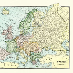
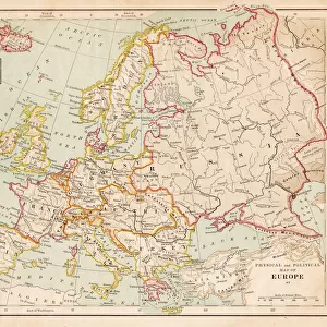
Fine Art Print : Map of Europe 1883


![]()
Fine Art Prints from Fine Art Storehouse
Map of Europe 1883
The Eclectic Elementary Geography by Van Antwerp, Bragg & C0 / Cincinnati -New York 1883
Unleash your creativity and transform your space into a visual masterpiece!
THEPALMER
Media ID 18357185
20"x16" (+3" Border) Fine Art Print
Step back in time with our exquisite Map of Europe 1883 print from THEPALMER's collection at Fine Art Storehouse. This vintage map, originally published in "The Eclectic Elementary Geography" by Van Antwerp, Bragg & Co. in 1883, offers a captivating glimpse into the historical cartography of Europe during the late 19th century. Add an air of nostalgia and academic charm to your space with this beautifully detailed and intricately designed piece. Each print is carefully produced using premium quality materials to ensure a stunning and long-lasting addition to your home or office decor.
20x16 image printed on 26x22 Fine Art Rag Paper with 3" (76mm) white border. Our Fine Art Prints are printed on 300gsm 100% acid free, PH neutral paper with archival properties. This printing method is used by museums and art collections to exhibit photographs and art reproductions.
Our fine art prints are high-quality prints made using a paper called Photo Rag. This 100% cotton rag fibre paper is known for its exceptional image sharpness, rich colors, and high level of detail, making it a popular choice for professional photographers and artists. Photo rag paper is our clear recommendation for a fine art paper print. If you can afford to spend more on a higher quality paper, then Photo Rag is our clear recommendation for a fine art paper print.
Estimated Image Size (if not cropped) is 50.8cm x 40.6cm (20" x 16")
Estimated Product Size is 66cm x 55.9cm (26" x 22")
These are individually made so all sizes are approximate
Artwork printed orientated as per the preview above, with landscape (horizontal) orientation to match the source image.
FEATURES IN THESE COLLECTIONS
> Maps and Charts
> Related Images
> North America
> United States of America
> New York
> New York
> Maps
> North America
> United States of America
> New York
> Related Images
> Fine Art Storehouse
> Map
> Historical Maps
EDITORS COMMENTS
In this photo print, we are transported back in time to the year 1883, where we find ourselves immersed in a beautifully detailed "Map of Europe". This remarkable piece is derived from "The Eclectic Elementary Geography" by Van Antwerp, Bragg & Co. , published in Cincinnati and New York during that era. As our eyes wander across the map's intricate design, we can't help but marvel at the craftsmanship and attention to detail. Every country, city, river, and mountain range is meticulously depicted with precision and accuracy. The vibrant colors used to distinguish each region bring life to an otherwise static representation of the continent. This historical artifact provides us with a glimpse into a world vastly different from our own. It serves as a reminder of how borders have shifted over time and how political landscapes have evolved throughout history. As we trace our fingers along the lines connecting nations on this vintage map, it sparks curiosity about what life was like for those living within these boundaries more than a century ago. "The Map of Europe 1883" by THEPALMER transports us back to an era when cartography was both an art form and a scientific endeavor. Its presence on display evokes nostalgia for simpler times while also serving as a testament to human ingenuity in capturing geographical knowledge. Whether you're an avid historian or simply appreciate fine art prints that tell stories through their imagery, this stunning reproduction offers endless fascination for anyone who gazes upon it.
MADE IN THE USA
Safe Shipping with 30 Day Money Back Guarantee
FREE PERSONALISATION*
We are proud to offer a range of customisation features including Personalised Captions, Color Filters and Picture Zoom Tools
SECURE PAYMENTS
We happily accept a wide range of payment options so you can pay for the things you need in the way that is most convenient for you
* Options may vary by product and licensing agreement. Zoomed Pictures can be adjusted in the Cart.