Fine Art Print > North America > United States of America > New York > New York > Maps
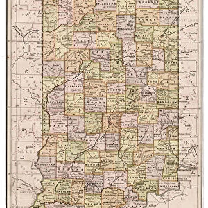
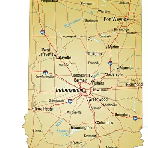
Fine Art Print : Map of Indiana 1894


![]()
Fine Art Prints from Fine Art Storehouse
Map of Indiana 1894
Johnsons Universal Cyclopedia - Volume IV New York - A. J. Johnson Company 1894
Unleash your creativity and transform your space into a visual masterpiece!
THEPALMER
Media ID 18356719
20"x16" (+3" Border) Fine Art Print
Discover the rich history of Indiana with this stunning fine art print from The Media Storehouse. Titled "Map of Indiana 1894," this captivating piece is taken from the pages of Johnsons Universal Cyclopedia - Volume IV, published by the A. J. Johnson Company in New York in 1894. The intricate detailing of the map showcases the geography and political boundaries of Indiana during that time, making it a unique and educational addition to any home or office. Bring a piece of the past into your present with this beautiful and historically significant fine art print.
20x16 image printed on 26x22 Fine Art Rag Paper with 3" (76mm) white border. Our Fine Art Prints are printed on 300gsm 100% acid free, PH neutral paper with archival properties. This printing method is used by museums and art collections to exhibit photographs and art reproductions.
Our fine art prints are high-quality prints made using a paper called Photo Rag. This 100% cotton rag fibre paper is known for its exceptional image sharpness, rich colors, and high level of detail, making it a popular choice for professional photographers and artists. Photo rag paper is our clear recommendation for a fine art paper print. If you can afford to spend more on a higher quality paper, then Photo Rag is our clear recommendation for a fine art paper print.
Estimated Image Size (if not cropped) is 40.6cm x 50.8cm (16" x 20")
Estimated Product Size is 55.9cm x 66cm (22" x 26")
These are individually made so all sizes are approximate
Artwork printed orientated as per the preview above, with portrait (vertical) orientation to match the source image.
FEATURES IN THESE COLLECTIONS
> Maps and Charts
> Related Images
> North America
> United States of America
> New York
> New York
> Maps
> North America
> United States of America
> New York
> Related Images
> Fine Art Storehouse
> Map
> Historical Maps
Map of Indiana 1894 - A Glimpse into the Past
EDITORS COMMENTS
. Step back in time with this print of the "Map of Indiana 1894". Taken from Johnsons Universal Cyclopedia, Volume IV, published by A. J. Johnson Company in New York, this vintage map offers a fascinating glimpse into the history and geography of Indiana during that era. The intricate details showcased on this print are truly remarkable. From its elegant typography to meticulously drawn boundaries and landmarks, every element tells a story about the state's rich heritage. The carefully chosen color palette adds an air of nostalgia, transporting you to a bygone era when cartography was both art and science. As you explore this map, let your imagination wander through bustling cities like Indianapolis or historic towns nestled along the Ohio River. Trace your finger along winding rivers and railway lines that once connected communities across the state. Marvel at how far we've come since those early days while appreciating our roots. Perfect for history enthusiasts or anyone seeking unique wall decor with a touch of vintage charm, this print captures not only a moment frozen in time but also serves as a reminder that maps hold stories waiting to be discovered. Add character to any space with "Map of Indiana 1894" lovingly curated by THEPALMER and available exclusively through Fine Art Storehouse. Let it spark conversations and ignite curiosity about our past as you proudly display this timeless piece within your home or office setting
MADE IN THE USA
Safe Shipping with 30 Day Money Back Guarantee
FREE PERSONALISATION*
We are proud to offer a range of customisation features including Personalised Captions, Color Filters and Picture Zoom Tools
SECURE PAYMENTS
We happily accept a wide range of payment options so you can pay for the things you need in the way that is most convenient for you
* Options may vary by product and licensing agreement. Zoomed Pictures can be adjusted in the Cart.