Fine Art Print > Fine Art Storehouse > Map
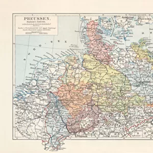
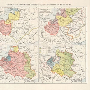
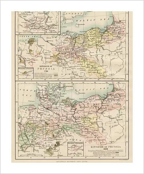
Fine Art Print : Map of Prussia 1883


![]()
Fine Art Prints from Fine Art Storehouse
Map of Prussia 1883
Encyclopedia Britannica 9th Edition New York Samuel L. Hall 1883 Vol XX
Unleash your creativity and transform your space into a visual masterpiece!
THEPALMER
Media ID 14756758
© This content is subject to copyright
20"x16" (+3" Border) Fine Art Print
Discover the rich historical detail of this exquisite Map of Prussia 1883, a fine art print from Media Storehouse. Meticulously reproduced from the Encyclopedia Britannica 9th Edition, New York, 1883, Volume XX, this vintage map by THEPALMER transports you back in time. With intricate cartography and precise geographical detail, this fine art print is a must-have for history buffs, cartography enthusiasts, and anyone who appreciates the beauty of historical maps. Bring a piece of the past into your home or office with this stunning and authentic work of art.
20x16 image printed on 26x22 Fine Art Rag Paper with 3" (76mm) white border. Our Fine Art Prints are printed on 300gsm 100% acid free, PH neutral paper with archival properties. This printing method is used by museums and art collections to exhibit photographs and art reproductions.
Our fine art prints are high-quality prints made using a paper called Photo Rag. This 100% cotton rag fibre paper is known for its exceptional image sharpness, rich colors, and high level of detail, making it a popular choice for professional photographers and artists. Photo rag paper is our clear recommendation for a fine art paper print. If you can afford to spend more on a higher quality paper, then Photo Rag is our clear recommendation for a fine art paper print.
Estimated Image Size (if not cropped) is 40.6cm x 50.8cm (16" x 20")
Estimated Product Size is 55.9cm x 66cm (22" x 26")
These are individually made so all sizes are approximate
Artwork printed orientated as per the preview above, with portrait (vertical) orientation to match the source image.
FEATURES IN THESE COLLECTIONS
> Fine Art Storehouse
> Map
> Historical Maps
EDITORS COMMENTS
This print showcases a historical treasure, the "Map of Prussia 1883" sourced from the esteemed Encyclopedia Britannica 9th Edition. A true testament to the artistry and precision of cartography, this piece takes us back in time to explore the vast territories of Prussia during its peak in the late 19th century. The intricate details and meticulous craftsmanship evident in every inch of this map are a testament to the dedication and expertise of its creator. The rich hues and fine lines beautifully capture not only geographical boundaries but also provide glimpses into an era long gone. As we gaze upon this remarkable work, we can almost feel ourselves transported to bustling cities, serene countryside landscapes, and majestic castles that once dotted Prussian lands. Printed with utmost care by THEPALMER at Fine Art Storehouse, this stunning reproduction allows history enthusiasts, scholars, or anyone with an appreciation for vintage aesthetics to own a piece of Prussian heritage. Whether displayed on office walls or cherished within personal collections, this print serves as both an educational tool and a visual delight. Embrace the opportunity to immerse yourself in history through this exceptional artwork – let it ignite your curiosity about past civilizations while adding elegance and sophistication to any space it graces.
MADE IN THE USA
Safe Shipping with 30 Day Money Back Guarantee
FREE PERSONALISATION*
We are proud to offer a range of customisation features including Personalised Captions, Color Filters and Picture Zoom Tools
SECURE PAYMENTS
We happily accept a wide range of payment options so you can pay for the things you need in the way that is most convenient for you
* Options may vary by product and licensing agreement. Zoomed Pictures can be adjusted in the Cart.