Fine Art Print > Oceania > Samoa > Maps
Fine Art Print : Map of Samoan islands: Savai i, Upolu, and Tutuila, lithograph, 1897


![]()
Fine Art Prints from Fine Art Storehouse
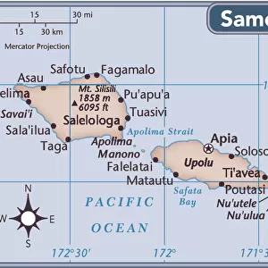
Map of Samoan islands: Savai i, Upolu, and Tutuila, lithograph, 1897
Topographic map of Samoan islands: Savai i, Upolu, Tutuila (American Samoa) and separate maps of Upolu and the port of Apia. Lithograph, published in 1897
Unleash your creativity and transform your space into a visual masterpiece!
ZU_09
Media ID 18356557
21"x14" (+3" Border) Fine Art Print
Discover the rich history and culture of the Pacific Islands with this stunning lithograph of the Samoan islands from Media Storehouse's Fine Art Prints collection. Dated back to 1897, this intricately detailed map showcases the beautiful archipelago of Savaii, Upolu, and Tutuila, including separate maps of Upolu and the port of Apia. Bring a piece of history into your home or office with this exquisite work by ZU_09, perfect for those who appreciate the art of cartography and the wonders of the world.
21x14 image printed on 27x20 Fine Art Rag Paper with 3" (76mm) white border. Our Fine Art Prints are printed on 300gsm 100% acid free, PH neutral paper with archival properties. This printing method is used by museums and art collections to exhibit photographs and art reproductions.
Our fine art prints are high-quality prints made using a paper called Photo Rag. This 100% cotton rag fibre paper is known for its exceptional image sharpness, rich colors, and high level of detail, making it a popular choice for professional photographers and artists. Photo rag paper is our clear recommendation for a fine art paper print. If you can afford to spend more on a higher quality paper, then Photo Rag is our clear recommendation for a fine art paper print.
Estimated Image Size (if not cropped) is 53.3cm x 33.9cm (21" x 13.3")
Estimated Product Size is 68.6cm x 50.8cm (27" x 20")
These are individually made so all sizes are approximate
Artwork printed orientated as per the preview above, with landscape (horizontal) orientation to match the source image.
FEATURES IN THESE COLLECTIONS
> Maps and Charts
> Related Images
> Oceania
> Samoa
> Related Images
> Fine Art Storehouse
> Map
> Historical Maps
EDITORS COMMENTS
This lithograph from 1897 showcases a detailed map of the enchanting Samoan islands. The print highlights three main islands: Savai'i, Upolu, and Tutuila, each with its own distinct features and allure. With intricate topographic details meticulously captured on paper, this piece offers a glimpse into the natural beauty that graces these Pacific gems. The larger map provides an overview of all three islands, allowing viewers to appreciate their relative positions and sizes in relation to one another. It invites exploration and sparks curiosity about what lies beyond their shores. Additionally, separate maps of Upolu Island and the bustling port of Apia offer more focused insights into specific regions within Samoa. The lithograph's vintage charm adds an extra layer of fascination as it transports us back in time to an era when cartography was both artistry and science. Its delicate lines and carefully chosen colors bring life to the landforms, rivers, coastlines, and settlements depicted on the map. Whether you have a personal connection to Samoa or simply admire exquisite cartographic works, this print is sure to captivate your imagination. Hang it proudly on your wall or display it in your study for daily inspiration as you embark on imaginary journeys through these mesmerizing South Pacific islands.
MADE IN THE USA
Safe Shipping with 30 Day Money Back Guarantee
FREE PERSONALISATION*
We are proud to offer a range of customisation features including Personalised Captions, Color Filters and Picture Zoom Tools
SECURE PAYMENTS
We happily accept a wide range of payment options so you can pay for the things you need in the way that is most convenient for you
* Options may vary by product and licensing agreement. Zoomed Pictures can be adjusted in the Cart.