Fine Art Print > Maps and Charts > Americas
Fine Art Print : Map of West Indies 1894


![]()
Fine Art Prints from Fine Art Storehouse
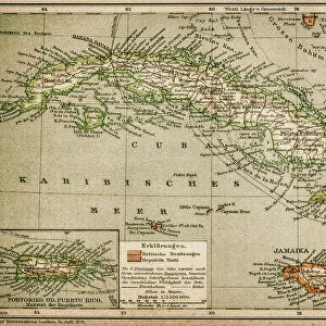
Map of West Indies 1894
Johnsons Universal Cyclopedia - Volume VIII New York - A. J. Johnson Company 1894
Unleash your creativity and transform your space into a visual masterpiece!
THEPALMER
Media ID 15256731
© This content is subject to copyright
Caribbean Central America Cuba Dominican Republic Honduras Mexico Nicaragua Panama Puerto Rico West Indies
20"x16" (+3" Border) Fine Art Print
Discover the captivating allure of the past with our exquisite Map of the West Indies by THEPALMER from the Media Storehouse Fine Art Prints collection. This intricately detailed map, originally published in Johnsons Universal Cyclopedia - Volume VIII by the A. J. Johnson Company in 1894, transports you back in time to the rich maritime history of the West Indies. With vibrant colors and meticulous craftsmanship, this fine art print adds an air of sophistication and intrigue to any room. Bring a piece of history into your home and elevate your decor with this stunning, vintage map.
20x16 image printed on 26x22 Fine Art Rag Paper with 3" (76mm) white border. Our Fine Art Prints are printed on 300gsm 100% acid free, PH neutral paper with archival properties. This printing method is used by museums and art collections to exhibit photographs and art reproductions.
Our fine art prints are high-quality prints made using a paper called Photo Rag. This 100% cotton rag fibre paper is known for its exceptional image sharpness, rich colors, and high level of detail, making it a popular choice for professional photographers and artists. Photo rag paper is our clear recommendation for a fine art paper print. If you can afford to spend more on a higher quality paper, then Photo Rag is our clear recommendation for a fine art paper print.
Estimated Image Size (if not cropped) is 50.8cm x 40.6cm (20" x 16")
Estimated Product Size is 66cm x 55.9cm (26" x 22")
These are individually made so all sizes are approximate
Artwork printed orientated as per the preview above, with landscape (horizontal) orientation to match the source image.
FEATURES IN THESE COLLECTIONS
> Maps and Charts
> Related Images
> North America
> Cuba
> Maps
> North America
> Cuba
> Related Images
> North America
> Dominican Republic
> Maps
> North America
> Dominican Republic
> Related Images
> North America
> Honduras
> Maps
> North America
> Honduras
> Related Images
> North America
> Mexico
> Related Images
> North America
> Nicaragua
> Maps
> Fine Art Storehouse
> Map
> Historical Maps
EDITORS COMMENTS
In this print titled "Map of West Indies 1894" we are transported back in time to an era when exploration and discovery were at the forefront. The intricate details and vibrant colors of this vintage map, sourced from Johnsons Universal Cyclopedia - Volume VIII New York - A. J. Johnson Company 1894, invite us to embark on a visual journey through the Caribbean region. The map encompasses a vast area, stretching from Cuba in the northwest to Puerto Rico in the northeast, with Central American countries such as Honduras, Nicaragua, Panama, and even parts of Mexico included. Each country is delicately outlined with precise cartographic accuracy that reflects both historical significance and geographical beauty. As we gaze upon this piece by THEPALMER from Fine Art Storehouse, our imagination runs wild with thoughts of explorers setting sail across turquoise waters towards unknown lands rich in culture and natural wonders. It serves as a reminder of how maps have always been essential tools for understanding our world's diverse landscapes. Whether you have a personal connection to these regions or simply appreciate the artistry behind antique maps, "Map of West Indies 1894" offers a glimpse into history while adding an air of sophistication to any space it graces. Let its timeless charm transport you back to an era where curiosity knew no bounds and adventure awaited at every turn.
MADE IN THE USA
Safe Shipping with 30 Day Money Back Guarantee
FREE PERSONALISATION*
We are proud to offer a range of customisation features including Personalised Captions, Color Filters and Picture Zoom Tools
SECURE PAYMENTS
We happily accept a wide range of payment options so you can pay for the things you need in the way that is most convenient for you
* Options may vary by product and licensing agreement. Zoomed Pictures can be adjusted in the Cart.