Fine Art Print > North America > United States of America > New York > New York > Maps
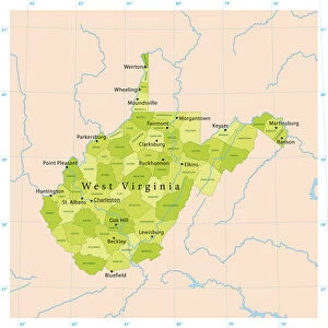
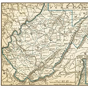
Fine Art Print : Map of West Virginia 1894


![]()
Fine Art Prints from Fine Art Storehouse
Map of West Virginia 1894
Johnsons Universal Cyclopedia - Volume VIII New York - A. J. Johnson Company 1894
Unleash your creativity and transform your space into a visual masterpiece!
THEPALMER
Media ID 18356743
21"x14" (+3" Border) Fine Art Print
Discover the rich history of West Virginia through the captivating lens of the past with our exquisite Map of West Virginia 1894 by THEPALMER from the Fine Art Storehouse collection. This vintage map, originally published in Johnsons Universal Cyclopedia - Volume VIII by the A.J. Johnson Company in 1894, showcases intricate details of the Mountain State's topography, towns, and counties. Bring a piece of historical cartography into your home or office and transport yourself back in time with this stunning fine art print.
21x14 image printed on 27x20 Fine Art Rag Paper with 3" (76mm) white border. Our Fine Art Prints are printed on 300gsm 100% acid free, PH neutral paper with archival properties. This printing method is used by museums and art collections to exhibit photographs and art reproductions.
Our fine art prints are high-quality prints made using a paper called Photo Rag. This 100% cotton rag fibre paper is known for its exceptional image sharpness, rich colors, and high level of detail, making it a popular choice for professional photographers and artists. Photo rag paper is our clear recommendation for a fine art paper print. If you can afford to spend more on a higher quality paper, then Photo Rag is our clear recommendation for a fine art paper print.
Estimated Image Size (if not cropped) is 53.3cm x 35.5cm (21" x 14")
Estimated Product Size is 68.6cm x 50.8cm (27" x 20")
These are individually made so all sizes are approximate
Artwork printed orientated as per the preview above, with landscape (horizontal) orientation to match the source image.
FEATURES IN THESE COLLECTIONS
> Maps and Charts
> Related Images
> North America
> United States of America
> New York
> New York
> Maps
> North America
> United States of America
> New York
> Related Images
> Fine Art Storehouse
> Map
> Historical Maps
EDITORS COMMENTS
In this print titled "Map of West Virginia 1894" we are transported back in time to the late 19th century, where cartography was an art form and exploration of new territories was still unfolding. The map, sourced from Johnsons Universal Cyclopedia - Volume VIII New York - A. J. Johnson Company 1894, offers a glimpse into the intricate details and craftsmanship that went into creating these historical documents. As we delve into the image, our eyes are immediately drawn to the beautifully illustrated contours of West Virginia's landscape. Every river, mountain range, and town is meticulously labeled with elegant typography that adds a touch of sophistication to this piece. It serves as a reminder of how maps were once cherished possessions used for navigation and discovery. The sepia-toned hues lend an air of nostalgia to the print, evoking memories of a bygone era when life moved at a slower pace. This particular rendition showcases not only geographical information but also provides insights into the state's history and development during that period. "The Map of West Virginia 1894" captures both artistic beauty and historical significance in one frame. Its presence on display invites us to appreciate the meticulous workmanship involved in creating such detailed maps while offering us an opportunity to reflect on how far we have come since those early days of exploration and discovery.
MADE IN THE USA
Safe Shipping with 30 Day Money Back Guarantee
FREE PERSONALISATION*
We are proud to offer a range of customisation features including Personalised Captions, Color Filters and Picture Zoom Tools
SECURE PAYMENTS
We happily accept a wide range of payment options so you can pay for the things you need in the way that is most convenient for you
* Options may vary by product and licensing agreement. Zoomed Pictures can be adjusted in the Cart.