Fine Art Print > North America > United States of America > New York > New York > Maps
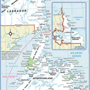
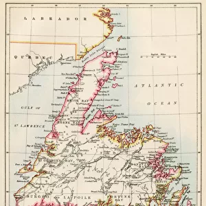
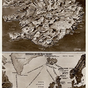
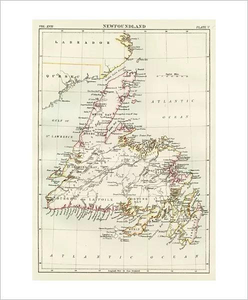
Fine Art Print : Newfoundland map 1884


![]()
Fine Art Prints from Fine Art Storehouse
Newfoundland map 1884
Encyclopedia Britannica 9th Edition New York Charles Scribners and Sonsl 1884 Vol XVII
Unleash your creativity and transform your space into a visual masterpiece!
THEPALMER
Media ID 14756688
© This content is subject to copyright
20"x16" (+3" Border) Fine Art Print
Step back in time with our exquisite Newfoundland Map print from ThePalmer, available in the Media Storehouse Fine Art Prints collection. Originally published in the Encyclopedia Britannica 9th Edition in 1884 by Charles Scribner's Sons in New York, this vintage map offers a captivating glimpse into the historical cartography of Newfoundland. The intricate details and authentic antique charm make this print an exceptional addition to any home or office, transporting you to a bygone era. Bring history to life with this beautiful and authentic work of art.
20x16 image printed on 26x22 Fine Art Rag Paper with 3" (76mm) white border. Our Fine Art Prints are printed on 300gsm 100% acid free, PH neutral paper with archival properties. This printing method is used by museums and art collections to exhibit photographs and art reproductions.
Our fine art prints are high-quality prints made using a paper called Photo Rag. This 100% cotton rag fibre paper is known for its exceptional image sharpness, rich colors, and high level of detail, making it a popular choice for professional photographers and artists. Photo rag paper is our clear recommendation for a fine art paper print. If you can afford to spend more on a higher quality paper, then Photo Rag is our clear recommendation for a fine art paper print.
Estimated Image Size (if not cropped) is 35.7cm x 50.8cm (14.1" x 20")
Estimated Product Size is 55.9cm x 66cm (22" x 26")
These are individually made so all sizes are approximate
Artwork printed orientated as per the preview above, with portrait (vertical) orientation to match the source image.
FEATURES IN THESE COLLECTIONS
> Maps and Charts
> Related Images
> North America
> Canada
> Maps
> North America
> Canada
> Related Images
> North America
> United States of America
> New York
> New York
> Maps
> North America
> United States of America
> New York
> Related Images
> Fine Art Storehouse
> Map
> Historical Maps
EDITORS COMMENTS
This print showcases a historical treasure, the Newfoundland map from the 1884 Encyclopedia Britannica's 9th Edition. A true testament to the art of cartography, this exquisite piece takes us back in time to an era when exploration and discovery were at their peak. The intricate details and precision with which this map was crafted are truly awe-inspiring. The Newfoundland map encompasses not only its namesake province but also regions such as Labrador, Quebec, and Canada as a whole. Its rich colors and fine lines bring life to the diverse landscapes that make up this vast territory. From rugged coastlines to sprawling forests, one can almost feel the adventurous spirit that must have filled those who first set foot on these lands. Expertly preserved by THEPALMER, this print allows us to marvel at both the beauty of nature and human ingenuity. It serves as a reminder of our collective history and how far we have come since those early days of exploration. Whether you are a history enthusiast or simply appreciate fine art, this remarkable piece is sure to captivate your imagination. Let yourself be transported through time with this stunning Newfoundland map from 1884 - an extraordinary addition for any collector or lover of vintage treasures.
MADE IN THE USA
Safe Shipping with 30 Day Money Back Guarantee
FREE PERSONALISATION*
We are proud to offer a range of customisation features including Personalised Captions, Color Filters and Picture Zoom Tools
SECURE PAYMENTS
We happily accept a wide range of payment options so you can pay for the things you need in the way that is most convenient for you
* Options may vary by product and licensing agreement. Zoomed Pictures can be adjusted in the Cart.