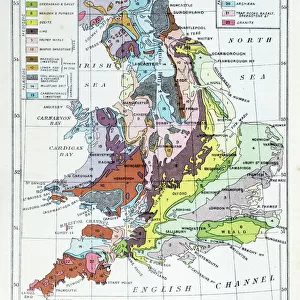
Fine Art Print : Victorian Geological Map of the British Isles


![]()
Fine Art Prints from Fine Art Storehouse
Victorian Geological Map of the British Isles
Vintage engraving of a Victorian Geological Map of the British Isles
Unleash your creativity and transform your space into a visual masterpiece!
duncan1890
Media ID 13667043
© duncan1890
78279 Geology Igneous Rock Mineral Natural Phenomenon Navigational Equipment Northern Europe Styles Image Created 19th Century Victorian Style
20"x16" (+3" Border) Fine Art Print
Step back in time with our exquisite Victorian Geological Map of the British Isles by duncan1890 from the Media Storehouse Fine Art Prints collection. This vintage engraving transports you to an era of scientific discovery and exploration. The intricate details of the geological formations and borders of the British Isles are beautifully captured, making this print an exceptional addition to any home or office. Bring history and geology together in your space with this timeless piece from Media Storehouse Fine Art Prints.
20x16 image printed on 26x22 Fine Art Rag Paper with 3" (76mm) white border. Our Fine Art Prints are printed on 300gsm 100% acid free, PH neutral paper with archival properties. This printing method is used by museums and art collections to exhibit photographs and art reproductions.
Our fine art prints are high-quality prints made using a paper called Photo Rag. This 100% cotton rag fibre paper is known for its exceptional image sharpness, rich colors, and high level of detail, making it a popular choice for professional photographers and artists. Photo rag paper is our clear recommendation for a fine art paper print. If you can afford to spend more on a higher quality paper, then Photo Rag is our clear recommendation for a fine art paper print.
Estimated Image Size (if not cropped) is 40.6cm x 50.8cm (16" x 20")
Estimated Product Size is 55.9cm x 66cm (22" x 26")
These are individually made so all sizes are approximate
Artwork printed orientated as per the preview above, with portrait (vertical) orientation to match the source image.
EDITORS COMMENTS
This vintage engraving takes us back to the 19th century, immersing us in the intricate world of Victorian cartography. The image showcases a meticulously detailed Geological Map of the British Isles, showcasing the immense talent and artistry that went into creating such maps during this era. The print exudes an air of antiquity, transporting us to a time when woodcuts and engravings were the pinnacle of visual representation. Every line and contour on this map tells a story about the physical geography and geology of this region, capturing both scientific knowledge and artistic beauty. As we explore this historical artifact, we are reminded of how far our understanding of mineral formations has come since then. From igneous rocks to natural phenomena, each element is carefully depicted with precision and accuracy. This map not only serves as a navigational tool but also as a testament to human curiosity about our surroundings. With its vertical orientation, it demands attention from any viewer who encounters it. Its presence evokes feelings of wonderment at how much has changed over time while appreciating the timeless allure that history holds. Duncan1890's creation allows us to delve into an age where styles were defined by meticulous craftsmanship. It invites us to appreciate not only the geological wonders captured within but also pays homage to an era long gone yet forever preserved through artistry like this remarkable print.
MADE IN THE USA
Safe Shipping with 30 Day Money Back Guarantee
FREE PERSONALISATION*
We are proud to offer a range of customisation features including Personalised Captions, Color Filters and Picture Zoom Tools
SECURE PAYMENTS
We happily accept a wide range of payment options so you can pay for the things you need in the way that is most convenient for you
* Options may vary by product and licensing agreement. Zoomed Pictures can be adjusted in the Cart.