Fine Art Print > Europe > France > Maps
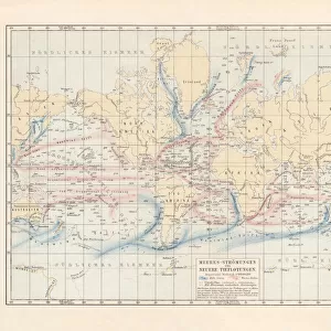
Fine Art Print : world map 1882


![]()
Fine Art Prints from Fine Art Storehouse
world map 1882
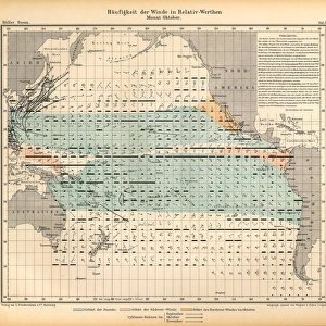
french map of the world showing the trajectories of travels and discovery around 1780 and 1822 - map is from 1882
Unleash your creativity and transform your space into a visual masterpiece!
THEPALMER
Media ID 18443327
© Roberto A Sanchez
20"x16" (+3" Border) Fine Art Print
Discover the rich history of exploration with our exquisite Fine Art Print from The Palmer Map Collection at Media Storehouse. This stunning representation of the world, titled "Map of the World Showing the Trajectories of Travels and Discoveries around 1780 and 1822," is an 1882 French masterpiece that captures the spirit of adventure. Each intricate detail on this vintage map tells a story of early voyages and discoveries, making it a captivating addition to any home or office. Bring history to life with this beautiful and authentic work of art.
20x16 image printed on 26x22 Fine Art Rag Paper with 3" (76mm) white border. Our Fine Art Prints are printed on 300gsm 100% acid free, PH neutral paper with archival properties. This printing method is used by museums and art collections to exhibit photographs and art reproductions.
Our fine art prints are high-quality prints made using a paper called Photo Rag. This 100% cotton rag fibre paper is known for its exceptional image sharpness, rich colors, and high level of detail, making it a popular choice for professional photographers and artists. Photo rag paper is our clear recommendation for a fine art paper print. If you can afford to spend more on a higher quality paper, then Photo Rag is our clear recommendation for a fine art paper print.
Estimated Image Size (if not cropped) is 50.8cm x 35.7cm (20" x 14.1")
Estimated Product Size is 66cm x 55.9cm (26" x 22")
These are individually made so all sizes are approximate
Artwork printed orientated as per the preview above, with landscape (horizontal) orientation to match the source image.
FEATURES IN THESE COLLECTIONS
> Maps and Charts
> Related Images
> Maps and Charts
> World
> Fine Art Storehouse
> Map
> Historical Maps
EDITORS COMMENTS
In this print titled "World Map 1882" we are transported back in time to an era of exploration and discovery. The map, a French creation from the late 19th century, beautifully showcases the trajectories of travels and expeditions that took place between 1780 and 1822. As we gaze upon this vintage piece of cartography, a sense of nostalgia washes over us. It is a testament to the artistry and precision that went into creating such intricate maps during a time when technology was limited. Every line, curve, and detail tells a story of brave explorers venturing into uncharted territories across the globe. The retro revival aesthetic adds another layer of charm to this piece. Its antique appearance evokes feelings of wonderment as we imagine what it must have been like for those early adventurers setting sail on their journeys with nothing but their wits and determination. This world map serves not only as an artistic representation but also as a valuable educational tool. It invites us to study physical geography in its purest form – showcasing continents, oceans, mountain ranges, rivers, and other geographical features without any modern overlays or political boundaries. "The World Map 1882" by THEPALMER is truly a treasure from Fine Art Storehouse's collection. It allows us to appreciate both the beauty of cartography as an art form and the historical significance behind these ancient voyages that shaped our understanding of our planet's vastness.
MADE IN THE USA
Safe Shipping with 30 Day Money Back Guarantee
FREE PERSONALISATION*
We are proud to offer a range of customisation features including Personalised Captions, Color Filters and Picture Zoom Tools
SECURE PAYMENTS
We happily accept a wide range of payment options so you can pay for the things you need in the way that is most convenient for you
* Options may vary by product and licensing agreement. Zoomed Pictures can be adjusted in the Cart.