Fine Art Print > Europe > Italy > Maps
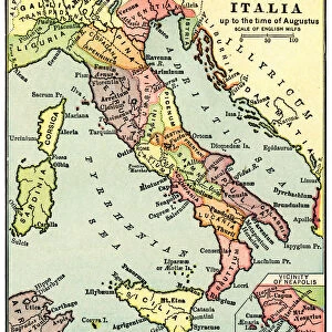
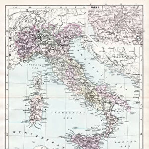
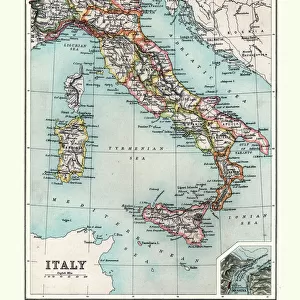
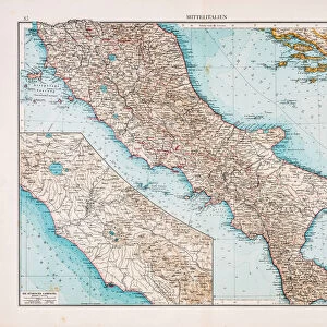
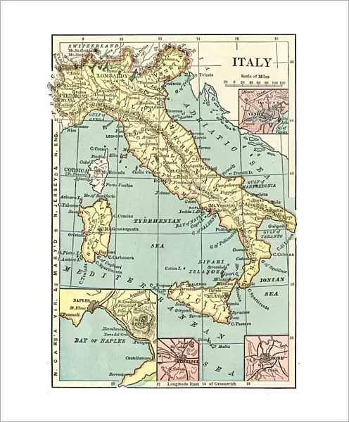
Fine Art Print : Map of Italy 1889


![]()
Fine Art Prints from Fine Art Storehouse
Map of Italy 1889
Comprehensive Geography by James Monteith - American Book Company 1882, 1889
Unleash your creativity and transform your space into a visual masterpiece!
THEPALMER
Media ID 18357269
20"x16" (+3" Border) Fine Art Print
Discover the rich history and culture of Italy with this exquisite fine art print from Media Storehouse. Featuring the detailed and captivating Map of Italy from THEPALMER's Comprehensive Geography published by the American Book Company in 1889, this print is a stunning addition to any home or office. Transport yourself back in time as you explore the intricacies of Italy's geography, borders, and historical landmarks. Perfect for history enthusiasts, geography buffs, or anyone who appreciates the beauty of vintage maps, this fine art print is sure to make a statement and spark conversation.
20x16 image printed on 26x22 Fine Art Rag Paper with 3" (76mm) white border. Our Fine Art Prints are printed on 300gsm 100% acid free, PH neutral paper with archival properties. This printing method is used by museums and art collections to exhibit photographs and art reproductions.
Our fine art prints are high-quality prints made using a paper called Photo Rag. This 100% cotton rag fibre paper is known for its exceptional image sharpness, rich colors, and high level of detail, making it a popular choice for professional photographers and artists. Photo rag paper is our clear recommendation for a fine art paper print. If you can afford to spend more on a higher quality paper, then Photo Rag is our clear recommendation for a fine art paper print.
Estimated Image Size (if not cropped) is 35.9cm x 50.8cm (14.1" x 20")
Estimated Product Size is 55.9cm x 66cm (22" x 26")
These are individually made so all sizes are approximate
Artwork printed orientated as per the preview above, with portrait (vertical) orientation to match the source image.
FEATURES IN THESE COLLECTIONS
> Europe
> Italy
> Related Images
> Maps and Charts
> Italy
> Maps and Charts
> Related Images
> Fine Art Storehouse
> Map
> Historical Maps
> Fine Art Storehouse
> Map
> Italian Maps
EDITORS COMMENTS
In this print titled "Map of Italy 1889" we are transported back in time to the late 19th century, where cartography was an art form meticulously crafted by skilled hands. This particular map is a reproduction from James Monteith's renowned book "Comprehensive Geography" published by the American Book Company in both 1882 and 1889. The intricacy and detail of this map are truly remarkable, showcasing Italy's diverse topography, cities, rivers, and borders with utmost precision. It serves as a testament to the dedication and expertise required to create such comprehensive geographical representations during that era. As we gaze upon this vintage masterpiece expertly captured by THEPALMER for Fine Art Storehouse, we can't help but marvel at its historical significance. It offers us a glimpse into Italy's past - a nation rich in culture, history, and natural beauty. Whether you're an avid collector or simply appreciate the allure of antique maps, this print is sure to captivate your imagination. Its timeless charm makes it suitable for various settings – be it adorning the walls of a study or adding character to a living room. Allow yourself to be transported through time as you explore every intricate detail on display within this exquisite piece. Let it serve as a reminder that even in our modern age of digital mapping technology; there remains something undeniably enchanting about these tangible relics from yesteryears' cartographic endeavors.
MADE IN THE USA
Safe Shipping with 30 Day Money Back Guarantee
FREE PERSONALISATION*
We are proud to offer a range of customisation features including Personalised Captions, Color Filters and Picture Zoom Tools
SECURE PAYMENTS
We happily accept a wide range of payment options so you can pay for the things you need in the way that is most convenient for you
* Options may vary by product and licensing agreement. Zoomed Pictures can be adjusted in the Cart.