Fine Art Print > Europe > France > Maps
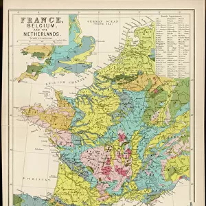
Fine Art Print : France country map


Fine Art Prints from Fine Art Storehouse
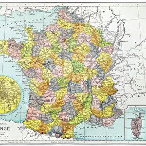
France country map
2011 edition
Unleash your creativity and transform your space into a visual masterpiece!
Media ID 14432127
20"x16" (+3" Border) Fine Art Print
20x16 image printed on 26x22 Fine Art Rag Paper with 3" (76mm) white border. Our Fine Art Prints are printed on 300gsm 100% acid free, PH neutral paper with archival properties. This printing method is used by museums and art collections to exhibit photographs and art reproductions.
Our fine art prints are high-quality prints made using a paper called Photo Rag. This 100% cotton rag fibre paper is known for its exceptional image sharpness, rich colors, and high level of detail, making it a popular choice for professional photographers and artists. Photo rag paper is our clear recommendation for a fine art paper print. If you can afford to spend more on a higher quality paper, then Photo Rag is our clear recommendation for a fine art paper print.
Estimated Image Size (if not cropped) is 40.6cm x 50.8cm (16" x 20")
Estimated Product Size is 55.9cm x 66cm (22" x 26")
These are individually made so all sizes are approximate
Artwork printed orientated as per the preview above, with portrait (vertical) orientation to match the source image.
FEATURES IN THESE COLLECTIONS
> Maps and Charts
> Related Images
> Fine Art Storehouse
> Map
> Reference Maps
> Fine Art Storehouse
> Top Sellers - Art Prints
EDITORS COMMENTS
This stunning print showcases the intricate details of France's country map, specifically the 2011 edition. With its vibrant colors and precise cartographic lines, this artwork from Fine Art Storehouse is a true masterpiece that captures the essence of this beautiful European nation. The map depicts France's diverse landscapes, from the snow-capped peaks of the Alps to the picturesque vineyards of Bordeaux. It highlights major cities like Paris, Lyon, and Marseille, as well as smaller towns and villages that dot the countryside. The intricate network of rivers and lakes are intricately portrayed, showcasing France's rich water resources. Every inch of this print invites exploration and discovery. Whether you're planning a trip or simply fascinated by geography, this piece will transport you to every corner of France without leaving your home. Its detailed representation allows for an immersive experience as you trace your finger along winding roads or imagine strolling through historic streets. Hang it in your living room or office space to spark conversations about travel adventures or ignite memories from past visits to this enchanting country. This artwork serves not only as an aesthetic addition but also as a source of inspiration for wanderlust souls who yearn to explore all that France has to offer.
MADE IN THE USA
Safe Shipping with 30 Day Money Back Guarantee
FREE PERSONALISATION*
We are proud to offer a range of customisation features including Personalised Captions, Color Filters and Picture Zoom Tools
SECURE PAYMENTS
We happily accept a wide range of payment options so you can pay for the things you need in the way that is most convenient for you
* Options may vary by product and licensing agreement. Zoomed Pictures can be adjusted in the Cart.