Fine Art Print > Oceania > Solomon Islands > Maps
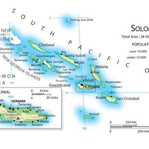
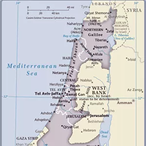
Fine Art Print : Solomon Islands country map


Please select a smaller print size for this image
![]()
Fine Art Prints from Fine Art Storehouse
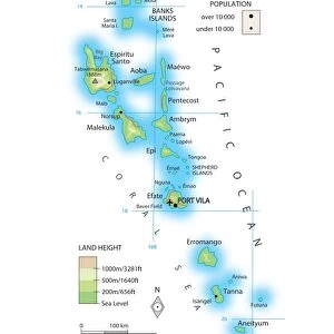
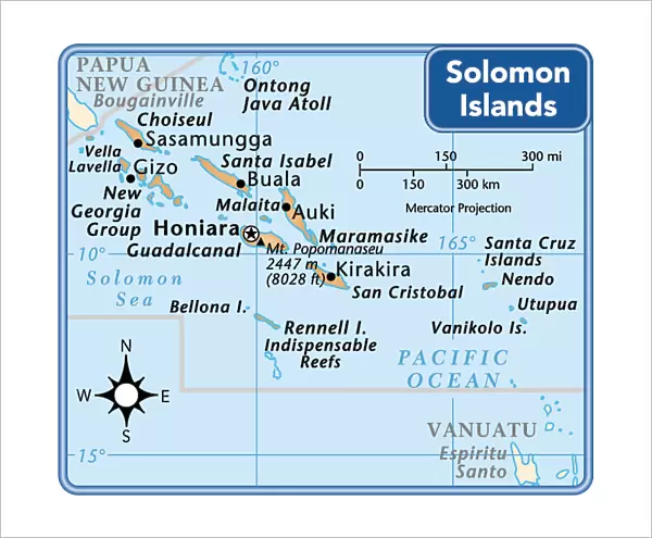
Solomon Islands country map
2011 edition
Unleash your creativity and transform your space into a visual masterpiece!
Media ID 15154205
20"x16" (+3" Border) Fine Art Print
Discover the captivating beauty of the Solomon Islands with our exquisite Fine Art Print from Media Storehouse. This 2011 edition map of the Solomon Islands is more than just a geographical representation - it's a work of art. Each print is meticulously crafted using high-quality materials and printing techniques to bring out the intricate details and vibrant colors of this stunning region. Hang it in your home or office to add a touch of exotic charm and inspire wanderlust. Let this fine art print transport you to the heart of the South Pacific and ignite your sense of adventure.
20x16 image printed on 26x22 Fine Art Rag Paper with 3" (76mm) white border. Our Fine Art Prints are printed on 300gsm 100% acid free, PH neutral paper with archival properties. This printing method is used by museums and art collections to exhibit photographs and art reproductions.
Our fine art prints are high-quality prints made using a paper called Photo Rag. This 100% cotton rag fibre paper is known for its exceptional image sharpness, rich colors, and high level of detail, making it a popular choice for professional photographers and artists. Photo rag paper is our clear recommendation for a fine art paper print. If you can afford to spend more on a higher quality paper, then Photo Rag is our clear recommendation for a fine art paper print.
Estimated Image Size (if not cropped) is 47.9cm x 40.6cm (18.9" x 16")
Estimated Product Size is 66cm x 55.9cm (26" x 22")
These are individually made so all sizes are approximate
Artwork printed orientated as per the preview above, with landscape (horizontal) orientation to match the source image.
FEATURES IN THESE COLLECTIONS
> Maps and Charts
> Related Images
> Oceania
> Solomon Islands
> Maps
> Oceania
> Solomon Islands
> Related Images
> Fine Art Storehouse
> Map
> Reference Maps
EDITORS COMMENTS
This print showcases the Solomon Islands country map in its 2011 edition, offering a mesmerizing glimpse into this enchanting archipelago. The intricate details of the map are beautifully captured, highlighting the diverse geography and rich cultural heritage that define these Pacific islands. The vivid colors and precise cartographic lines bring this artwork to life, inviting viewers to embark on a visual exploration of the Solomon Islands' stunning landscapes. From lush rainforests to pristine beaches and turquoise waters teeming with marine life, every corner of this paradise is unveiled through this exquisite print. As we gaze upon this masterpiece from Fine Art Storehouse, our imagination takes flight as we envision ourselves traversing across each island's unique topography. We can almost feel the warm tropical breeze caressing our skin as we mentally navigate through bustling villages and hidden gems waiting to be discovered. Beyond its aesthetic appeal, this photograph serves as an educational tool, providing valuable insights into the Solomon Islands' history and culture. It reminds us of their resilience in overcoming challenges while preserving their traditions for generations to come. Whether displayed in a home or office setting, this print acts as a window into an extraordinary world that beckons us to explore further. It sparks wanderlust within us all while celebrating the beauty found within these remote corners of our planet.
MADE IN THE USA
Safe Shipping with 30 Day Money Back Guarantee
FREE PERSONALISATION*
We are proud to offer a range of customisation features including Personalised Captions, Color Filters and Picture Zoom Tools
SECURE PAYMENTS
We happily accept a wide range of payment options so you can pay for the things you need in the way that is most convenient for you
* Options may vary by product and licensing agreement. Zoomed Pictures can be adjusted in the Cart.