Fine Art Print > South America > Suriname > Maps
Fine Art Print : Suriname country map


Please select a smaller print size for this image
![]()
Fine Art Prints from Fine Art Storehouse
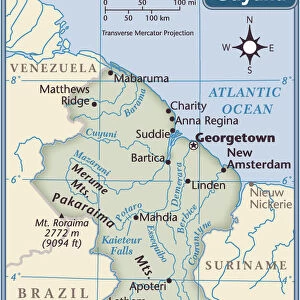
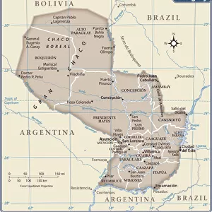
Suriname country map
2011 edition
Unleash your creativity and transform your space into a visual masterpiece!
Media ID 14432313
10"x8" (+3" Border) Fine Art Print
20x16 image printed on 26x22 Fine Art Rag Paper with 3" (76mm) white border. Our Fine Art Prints are printed on 300gsm 100% acid free, PH neutral paper with archival properties. This printing method is used by museums and art collections to exhibit photographs and art reproductions.
Our fine art prints are high-quality prints made using a paper called Photo Rag. This 100% cotton rag fibre paper is known for its exceptional image sharpness, rich colors, and high level of detail, making it a popular choice for professional photographers and artists. Photo rag paper is our clear recommendation for a fine art paper print. If you can afford to spend more on a higher quality paper, then Photo Rag is our clear recommendation for a fine art paper print.
Estimated Product Size is 35.6cm x 40.6cm (14" x 16")
These are individually made so all sizes are approximate
Artwork printed orientated as per the preview above, with portrait (vertical) orientation to match the source image.
FEATURES IN THESE COLLECTIONS
> Maps and Charts
> Related Images
> South America
> Suriname
> Maps
> South America
> Suriname
> Related Images
> Fine Art Storehouse
> Map
> Reference Maps
EDITORS COMMENTS
This stunning print showcases the Suriname country map, capturing its intricate details and vibrant colors. The 2011 edition of this map is a testament to the rich history and diverse geography that define this South American nation. From the lush rainforests in the south to the vast savannahs in the north, Suriname's natural beauty is beautifully depicted in this artwork. Rivers meander through its landscape, connecting remote villages and bustling cities alike. Each region is carefully labeled, allowing viewers to explore and appreciate Suriname's unique cultural heritage. The Fine Art Storehouse has expertly captured every contour of this map, ensuring that each line and boundary is crisp and clear. This print serves as both an educational tool for those seeking geographical knowledge and a decorative piece for art enthusiasts looking to add a touch of sophistication to their space. Whether you have personal ties to Suriname or simply admire its captivating charm from afar, this print offers a window into its enchanting world. Display it proudly on your wall or gift it to someone with an appreciation for cartography – either way, it will undoubtedly spark curiosity and conversation about one of South America's hidden gems.
MADE IN THE USA
Safe Shipping with 30 Day Money Back Guarantee
FREE PERSONALISATION*
We are proud to offer a range of customisation features including Personalised Captions, Color Filters and Picture Zoom Tools
SECURE PAYMENTS
We happily accept a wide range of payment options so you can pay for the things you need in the way that is most convenient for you
* Options may vary by product and licensing agreement. Zoomed Pictures can be adjusted in the Cart.