Fine Art Print > Arts > Street art graffiti > Digital art > Digital paintings
Fine Art Print : British Isles


![]()
Fine Art Prints from Fine Art Storehouse
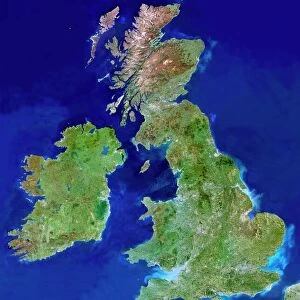
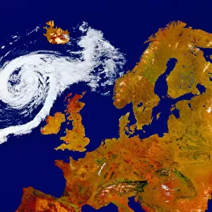
British Isles
Satellite Maps, dv057004
Unleash your creativity and transform your space into a visual masterpiece!
Digital Vision.
Media ID 14833399
© This content is subject to copyright
20"x16" (+3" Border) Fine Art Print
Discover the breathtaking beauty of the British Isles like never before with our exquisite Fine Art Print from Media Storehouse. This stunning piece, featuring a satellite map view of the British Isles by Digital Vision (dv057004), is part of our Fine Art Storehouse collection. Each print is meticulously crafted using the highest quality materials, ensuring vibrant colors and exceptional detail. Bring a touch of the enchanting British landscape into your home or office and elevate your decor with this unique and captivating work of art.
20x16 image printed on 26x22 Fine Art Rag Paper with 3" (76mm) white border. Our Fine Art Prints are printed on 300gsm 100% acid free, PH neutral paper with archival properties. This printing method is used by museums and art collections to exhibit photographs and art reproductions.
Our fine art prints are high-quality prints made using a paper called Photo Rag. This 100% cotton rag fibre paper is known for its exceptional image sharpness, rich colors, and high level of detail, making it a popular choice for professional photographers and artists. Photo rag paper is our clear recommendation for a fine art paper print. If you can afford to spend more on a higher quality paper, then Photo Rag is our clear recommendation for a fine art paper print.
Estimated Image Size (if not cropped) is 36.1cm x 50.8cm (14.2" x 20")
Estimated Product Size is 55.9cm x 66cm (22" x 26")
These are individually made so all sizes are approximate
Artwork printed orientated as per the preview above, with portrait (vertical) orientation to match the source image.
FEATURES IN THESE COLLECTIONS
> Arts
> Street art graffiti
> Digital art
> Digital paintings
> Maps and Charts
> Related Images
> Fine Art Storehouse
> Map
> Satellite Maps
EDITORS COMMENTS
This photo print, titled "British Isles (Satellite Maps, dv057004)" takes us on an awe-inspiring journey above the British Isles. Captured by Digital Vision and available at Fine Art Storehouse, this remarkable artwork showcases the beauty of our planet from a unique perspective. The image presents a bird's-eye view of the British Isles, revealing their intricate coastline and diverse topography. From the rugged cliffs of Cornwall to the rolling hills of Scotland, every detail is meticulously captured in stunning clarity. The satellite mapping technique employed here allows us to appreciate the vastness and complexity of this island nation. As we gaze upon this mesmerizing composition, we are reminded of both our insignificance in comparison to nature's grandeur and our deep connection with these lands. The vibrant colors that adorn the print evoke a sense of vitality and energy inherent in these ancient landscapes. Whether you have personal ties to Britain or simply admire its rich history and natural wonders, this print serves as a visual testament to its enduring allure. Display it proudly in your home or office space as a conversation starter or as an homage to one of Earth's most enchanting regions. With "British Isles (Satellite Maps, dv057004)" adorning your walls, you can embark on countless imaginary journeys across these captivating lands without ever leaving your doorstep. Let yourself be transported into this breathtaking realm where land meets sea and history intertwines with modernity – all through the lens of Digital Vision's artistry.
MADE IN THE USA
Safe Shipping with 30 Day Money Back Guarantee
FREE PERSONALISATION*
We are proud to offer a range of customisation features including Personalised Captions, Color Filters and Picture Zoom Tools
SECURE PAYMENTS
We happily accept a wide range of payment options so you can pay for the things you need in the way that is most convenient for you
* Options may vary by product and licensing agreement. Zoomed Pictures can be adjusted in the Cart.