Fine Art Print > Europe > United Kingdom > England > Lincolnshire > Spalding
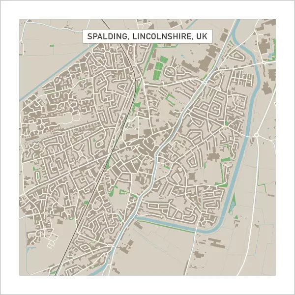
Fine Art Print : Spalding Lincolnshire UK City Street Map

![]()
Fine Art Prints from Fine Art Storehouse
Spalding Lincolnshire UK City Street Map
Vector Illustration of a City Street Map of Spalding, Lincolnshire, UK. Included files are EPS (v10) and Hi-Res JPG.
Data courtesy from Ordnance Survey: VectorMap District
https:/ordnancesurvey.co.uk/business-and-government/products/vectormap-district.html
OS OpenData is free to use under the Open Government Licence (OGL).
Contains OS data eCrown copyright and database right 2017.
http:/nationalarchives.gov.uk/doc/open-government-licence/version/3/
Unleash your creativity and transform your space into a visual masterpiece!
Frank Ramspott
Media ID 15055277
© Frank Ramspott, all rights reserved
Aerial View Computer Graphic Directly Above Gray Green Lincolnshire Road Map Street Map Text Digitally Generated Image River Welland Spalding
20"x20" (+3" Border) Fine Art Print
Discover the charm of Spalding, Lincolnshire with this exquisite city street map fine art print from Media Storehouse. Created by renowned artist Frank Ramspott, this vector illustration captures the essence of Spalding's unique character. With intricate details derived from Ordnance Survey's VectorMap District data, this fine art print is not just a map, but a work of art that tells a story. Bring a piece of Spalding's history and beauty into your home or office with this stunning and high-resolution print. Included files: EPS (v10) and Hi-Res JPG.
20x20 image printed on 26x26 Fine Art Rag Paper with 3" (76mm) white border. Our Fine Art Prints are printed on 300gsm 100% acid free, PH neutral paper with archival properties. This printing method is used by museums and art collections to exhibit photographs and art reproductions.
Our fine art prints are high-quality prints made using a paper called Photo Rag. This 100% cotton rag fibre paper is known for its exceptional image sharpness, rich colors, and high level of detail, making it a popular choice for professional photographers and artists. Photo rag paper is our clear recommendation for a fine art paper print. If you can afford to spend more on a higher quality paper, then Photo Rag is our clear recommendation for a fine art paper print.
Estimated Image Size (if not cropped) is 50.8cm x 50.8cm (20" x 20")
Estimated Product Size is 66cm x 66cm (26" x 26")
These are individually made so all sizes are approximate
Artwork printed orientated as per the preview above, with landscape (horizontal) or portrait (vertical) orientation to match the source image.
FEATURES IN THESE COLLECTIONS
> Aerial Photography
> Related Images
> Arts
> Contemporary art
> Digital artwork
> Street art
> Arts
> Landscape paintings
> Waterfall and river artworks
> River artworks
> Arts
> Portraits
> Pop art gallery
> Street art portraits
> Arts
> Street art graffiti
> Digital art
> Digital paintings
> Arts
> Street art graffiti
> Digital art
> Vector illustrations
> Europe
> United Kingdom
> England
> Lincolnshire
> Related Images
> Europe
> United Kingdom
> England
> Lincolnshire
> Spalding
> Europe
> United Kingdom
> Maps
> Maps and Charts
> Related Images
> Fine Art Storehouse
> Map
> Street Maps
EDITORS COMMENTS
This print showcases a detailed and intricate city street map of Spalding, Lincolnshire in the United Kingdom. The vector illustration is expertly crafted, providing an accurate representation of the town's layout and features. With included files in EPS (v10) and Hi-Res JPG formats, this print offers versatility for various uses. The data used to create this stunning piece of art is courtesy of Ordnance Survey: VectorMap District, a reliable source known for its accuracy. It's worth noting that OS OpenData allows free usage under the Open Government Licence (OGL), highlighting the accessibility and transparency behind this project. The image captures not only the streets but also important landmarks such as the River Welland flowing through Spalding. This aerial view provides a unique perspective on the physical geography of the area. The digitally generated design incorporates shades of gray, green, blue, and white to enhance readability while maintaining an aesthetically pleasing appearance. Perfectly suited for cartography enthusiasts or those with a connection to Spalding, this print by Frank Ramspott from Fine Art Storehouse is sure to spark curiosity and admiration for both locals and visitors alike.
MADE IN THE USA
Safe Shipping with 30 Day Money Back Guarantee
FREE PERSONALISATION*
We are proud to offer a range of customisation features including Personalised Captions, Color Filters and Picture Zoom Tools
SECURE PAYMENTS
We happily accept a wide range of payment options so you can pay for the things you need in the way that is most convenient for you
* Options may vary by product and licensing agreement. Zoomed Pictures can be adjusted in the Cart.