Fine Art Print > Europe > United Kingdom > Northern Ireland > Maps
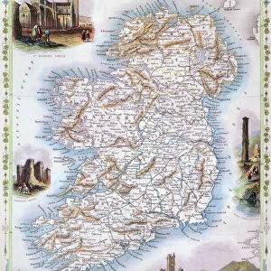
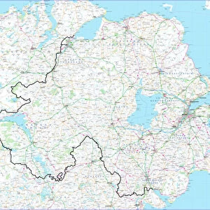
Fine Art Print : Antique Map of Northern Ireland, detail of Londonderry, 19th Century


![]()
Fine Art Prints from Fine Art Storehouse
Antique Map of Northern Ireland, detail of Londonderry, 19th Century
Antique Map of Northern Ireland, detail of Londonderry area, 19th Century
Unleash your creativity and transform your space into a visual masterpiece!
duncan1890
Media ID 21168549
© of Duncan P Walker
20"x16" (+3" Border) Fine Art Print
Step back in time with our exquisite Antique Map of Northern Ireland, featuring a captivating detail of Londonderry from the 19th Century. Meticulously crafted by skilled artist duncan1890, this Fine Art Print transports you to a bygone era with its intricate cartography and rich historical detail. Perfectly suited for those who appreciate the beauty of the past, this stunning piece is a must-have for any home or office. Bring history to life with the Media Storehouse range of Fine Art Prints.
20x16 image printed on 26x22 Fine Art Rag Paper with 3" (76mm) white border. Our Fine Art Prints are printed on 300gsm 100% acid free, PH neutral paper with archival properties. This printing method is used by museums and art collections to exhibit photographs and art reproductions.
Our fine art prints are high-quality prints made using a paper called Photo Rag. This 100% cotton rag fibre paper is known for its exceptional image sharpness, rich colors, and high level of detail, making it a popular choice for professional photographers and artists. Photo rag paper is our clear recommendation for a fine art paper print. If you can afford to spend more on a higher quality paper, then Photo Rag is our clear recommendation for a fine art paper print.
Estimated Image Size (if not cropped) is 50.8cm x 40.6cm (20" x 16")
Estimated Product Size is 66cm x 55.9cm (26" x 22")
These are individually made so all sizes are approximate
Artwork printed orientated as per the preview above, with landscape (horizontal) orientation to match the source image.
FEATURES IN THESE COLLECTIONS
> Europe
> Republic of Ireland
> Maps
> Europe
> United Kingdom
> Northern Ireland
> Londonderry
> Europe
> United Kingdom
> Northern Ireland
> Maps
> Europe
> United Kingdom
> Northern Ireland
> Posters
> Europe
> United Kingdom
> Northern Ireland
> Related Images
> Maps and Charts
> Related Images
> Fine Art Storehouse
> Map
> Historical Maps
> Fine Art Storehouse
> Travel Imagery
> Travel Destinations
> Ireland
> Londonderry, Northern Ireland
EDITORS COMMENTS
This print showcases an exquisite Antique Map of Northern Ireland, specifically highlighting the intricate details of Londonderry in the 19th century. Crafted by the talented artist duncan1890, this piece takes us on a nostalgic journey through time, offering a glimpse into the rich history and cultural heritage of this enchanting region. The map's delicate lines and meticulous craftsmanship transport us back to an era when cartography was both an art form and a means of exploration. Every street, river, and landmark is intricately depicted, capturing the essence of Londonderry during this significant period. As we delve into this historical gem, our imagination runs wild with tales from centuries past. We envision bustling streets filled with horse-drawn carriages and locals going about their daily lives amidst charming Georgian architecture. The map invites us to explore every nook and cranny of Londonderry's vibrant cityscape while unraveling its hidden stories. With its warm sepia tones evoking a sense of nostalgia, this print becomes more than just a decorative piece; it becomes a window into another time. Whether you have personal ties to Northern Ireland or simply appreciate historical artifacts, this Antique Map offers both beauty and educational value for any admirer. Displaying it proudly in your home or office will not only add sophistication but also spark conversations about the fascinating history that shaped one of United Kingdom's most iconic regions.
MADE IN THE USA
Safe Shipping with 30 Day Money Back Guarantee
FREE PERSONALISATION*
We are proud to offer a range of customisation features including Personalised Captions, Color Filters and Picture Zoom Tools
SECURE PAYMENTS
We happily accept a wide range of payment options so you can pay for the things you need in the way that is most convenient for you
* Options may vary by product and licensing agreement. Zoomed Pictures can be adjusted in the Cart.