Fine Art Print > Arts > Artists > O > Oceanic Oceanic
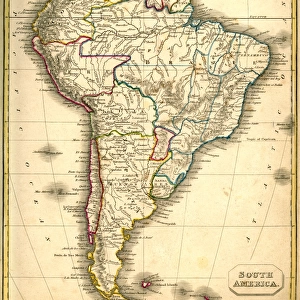
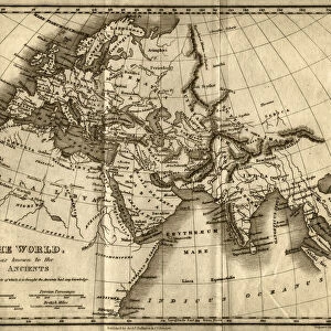
Fine Art Print : Map of South America (early 19th century steel engraving)
")


![]()
Fine Art Prints from Fine Art Storehouse
Map of South America (early 19th century steel engraving)
A steel engraving of a map from the early 19th century of Brazil and Paraguay in South America, from A System of Geography, Popular and Scientific, or A Physical, Political, and Statistical Account of the World and its Various Divisions. Volume VI, Part IIa by James Bell and published by A. Fullarton & Co. Glasgow, in 1838
Unleash your creativity and transform your space into a visual masterpiece!
whitemay
Media ID 13666941
© Linda Steward
1830s Style Amazon Region Amazon River Atlantic Ocean Bolivia Brazil Caribbean Sea Chile Colombia Document Education Equator Equator Line Exploration Falkland Islands Georgian Style Guyana Line Art Monochrome North Atlantic Ocean Pacific Ocean Paper Paraguay Past Patagonia Patagonia Argentina Patagonia Chile Peru Sepia Toned Social History South America South Pacific Ocean Stained Steel Engraving Topography Traditional Culture Vignette Cape Horn Chimborazo Crease Drawing Art Product Image Created 19th Century Obsolete South Atlantic Ocean Tropic Of Capricorn
20"x16" (+3" Border) Fine Art Print
Step back in time with our exquisite Map of South America from the early 19th century, part of the Fine Art Storehouse's collection. This intricately detailed steel engraving, titled "A System of Geography, Popular and Scientific, or A Physical, Political Atlas," showcases the geography of Brazil and Paraguay during an era of significant exploration and discovery. Add a touch of history and sophistication to your home or office with this stunning work of art, expertly crafted by the skilled engraver whitemay. Perfect for history enthusiasts, geography buffs, or anyone who appreciates the beauty of historical maps.
20x16 image printed on 26x22 Fine Art Rag Paper with 3" (76mm) white border. Our Fine Art Prints are printed on 300gsm 100% acid free, PH neutral paper with archival properties. This printing method is used by museums and art collections to exhibit photographs and art reproductions.
Our fine art prints are high-quality prints made using a paper called Photo Rag. This 100% cotton rag fibre paper is known for its exceptional image sharpness, rich colors, and high level of detail, making it a popular choice for professional photographers and artists. Photo rag paper is our clear recommendation for a fine art paper print. If you can afford to spend more on a higher quality paper, then Photo Rag is our clear recommendation for a fine art paper print.
Estimated Image Size (if not cropped) is 40.6cm x 50.5cm (16" x 19.9")
Estimated Product Size is 55.9cm x 66cm (22" x 26")
These are individually made so all sizes are approximate
Artwork printed orientated as per the preview above, with portrait (vertical) orientation to match the source image.
FEATURES IN THESE COLLECTIONS
> Arts
> Artists
> O
> Oceanic Oceanic
> Arts
> Contemporary art
> Photography
> Pop art
> Arts
> Landscape paintings
> Waterfall and river artworks
> River artworks
> Arts
> Still life artwork
> Pop art
> Photography
> Arts
> Minimalist artwork
> Monochrome artwork
> Black and white artwork
> Arts
> Minimalist artwork
> Monochrome artwork
> Fine art
> Arts
> Minimalist artwork
> Monochrome artwork
> Line drawings
> Arts
> Minimalist artwork
> Monochrome artwork
> Monochrome paintings
> Arts
> Minimalist artwork
> Monochrome artwork
> Monochrome photography
> Arts
> Minimalist artwork
> Monochrome paintings
> Line drawings
> Fine Art Storehouse
> Map
> Historical Maps
> Fine Art Storehouse
> Travel Imagery
> Travel Destinations
> patagonia
EDITORS COMMENTS
This steel engraving takes us back to the early 19th century, offering a glimpse into the intricate world of cartography. The print showcases a detailed map of South America, specifically highlighting Brazil and Paraguay. Created in 1838 by James Bell and published by A. Fullarton & Co. , this image is part of an esteemed collection titled "A System of Geography, Popular and Scientific". The monochrome line art adds a touch of elegance to the piece, while the sepia tone evokes a sense of nostalgia for times long gone. As we explore this engraved image, we are transported to an era when exploration was at its peak and traditional culture thrived. The map encompasses vast territories including Peru, Guyana, Colombia, Patagonia, Chile, Bolivia, and even stretches across the Pacific Ocean towards the Caribbean Sea. It beautifully depicts geographical features such as Cape Horn and Chimborazo while tracing important landmarks like the Amazon River. As we observe this aged document on stained paper with creases that tell stories untold, it reminds us not only of our planet's physical geography but also offers insights into social history. This print serves as both an educational tool and a testament to human curiosity about our world. In this timeless artwork from Fine Art Storehouse by whitemay (not affiliated with any company), there are no people present; instead it invites us to appreciate the beauty found within maps themselves – their ability to transport us through time and space while preserving moments from our past.
MADE IN THE USA
Safe Shipping with 30 Day Money Back Guarantee
FREE PERSONALISATION*
We are proud to offer a range of customisation features including Personalised Captions, Color Filters and Picture Zoom Tools
SECURE PAYMENTS
We happily accept a wide range of payment options so you can pay for the things you need in the way that is most convenient for you
* Options may vary by product and licensing agreement. Zoomed Pictures can be adjusted in the Cart.