Fine Art Print > Arts > Artists > O > Abraham Ortelius
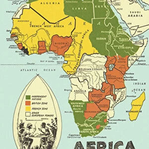
Fine Art Print : MAP OF AFRICA from the 1595 edition of Abraham Ortelius atlas Theatrum Orbis Terrarum


![]()
Fine Art Prints from Granger
MAP OF AFRICA from the 1595 edition of Abraham Ortelius atlas Theatrum Orbis Terrarum
MAP OF AFRICA from the 1595 edition of Abraham Ortelius atlas " Theatrum Orbis Terrarum."
Granger holds millions of images spanning more than 25,000 years of world history, from before the Stone Age to the dawn of the Space Age
Media ID 6617627
1595 Abraham Africa African Ortelius Theatrum Orbis Terrarum
20"x16" (+3" Border) Fine Art Print
Step back in time with our exquisite Fine Art Print from the Media Storehouse collection. This captivating piece showcases a rare and intriguing map of Africa from the 1595 edition of Abraham Ortelius's seminal work, "Theatrum Orbis Terrarum." Produced by The Granger Collection from Granger Art on Demand, this print offers a glimpse into the rich cartographic history of the world. The intricate details and vibrant colors of this antique map are sure to add an air of sophistication and intrigue to any room. Bring a piece of the past into your home or office with this stunning Fine Art Print from Media Storehouse.
20x16 image printed on 26x22 Fine Art Rag Paper with 3" (76mm) white border. Our Fine Art Prints are printed on 300gsm 100% acid free, PH neutral paper with archival properties. This printing method is used by museums and art collections to exhibit photographs and art reproductions.
Our fine art prints are high-quality prints made using a paper called Photo Rag. This 100% cotton rag fibre paper is known for its exceptional image sharpness, rich colors, and high level of detail, making it a popular choice for professional photographers and artists. Photo rag paper is our clear recommendation for a fine art paper print. If you can afford to spend more on a higher quality paper, then Photo Rag is our clear recommendation for a fine art paper print.
Estimated Image Size (if not cropped) is 50.8cm x 40.6cm (20" x 16")
Estimated Product Size is 66cm x 55.9cm (26" x 22")
These are individually made so all sizes are approximate
Artwork printed orientated as per the preview above, with landscape (horizontal) orientation to match the source image.
FEATURES IN THESE COLLECTIONS
> Africa
> Related Images
> Arts
> Art Movements
> Renaissance Art
> Arts
> Artists
> O
> Abraham Ortelius
> Arts
> Landscape paintings
> Waterfall and river artworks
> River artworks
> Maps and Charts
> Abraham Ortelius
> Maps and Charts
> Related Images
> Granger Art on Demand
> Maps
EDITORS COMMENTS
This print showcases a remarkable piece of history - the Map of Africa from the 1595 edition of Abraham Ortelius' renowned atlas, Theatrum Orbis Terrarum. A true gem from the Renaissance era, this map is a testament to Ortelius' pioneering cartographic skills and his dedication to accurately representing the world. The intricate details on this map transport us back in time, allowing us to explore Africa as it was perceived over four centuries ago. From its majestic rivers snaking through vast landscapes to its diverse regions marked with precision, every element tells a story of exploration and discovery. Ortelius' mastery shines through in his depiction of African geography, showcasing his deep understanding of the continent's topography. This print not only serves as an educational tool but also as a work of art that captures the essence and beauty of Africa during this period. As we gaze upon this historical artifact, we are reminded that maps have always been more than just navigational tools; they are windows into different eras and cultures. The Granger Collection has preserved this invaluable piece for us to appreciate and learn from, bridging the gap between past and present. Whether you're an avid historian or simply fascinated by African heritage, this print offers a glimpse into our collective human journey across time. Let it inspire you to delve deeper into Africa's rich history while appreciating Ortelius' contribution to our understanding of our world.
MADE IN THE USA
Safe Shipping with 30 Day Money Back Guarantee
FREE PERSONALISATION*
We are proud to offer a range of customisation features including Personalised Captions, Color Filters and Picture Zoom Tools
SECURE PAYMENTS
We happily accept a wide range of payment options so you can pay for the things you need in the way that is most convenient for you
* Options may vary by product and licensing agreement. Zoomed Pictures can be adjusted in the Cart.