Fine Art Print > Animals > Mammals > Cats (Domestic) > Somali
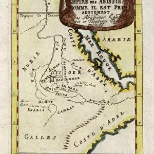
Fine Art Print : Afrique Orientale; Le Nord-Est Africain, 1914. Creator: Unknown


![]()
Fine Art Prints from Heritage Images
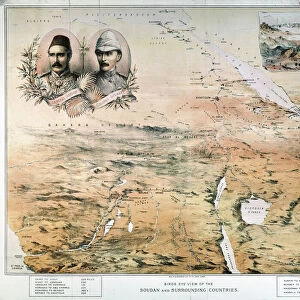
Afrique Orientale; Le Nord-Est Africain, 1914. Creator: Unknown
Afrique Orientale; Le Nord-Est Africain, 1914. From "Grande Geographie Bong Illustree", 1914
Heritage Images features heritage image collections
Media ID 36295903
© The Print Collector/Heritage Images
Abyssinia Cartography Colonies Colony East Africa East African Ethiopia Horn Of Africa Lake Victoria Map Making Mapmaking Red Sea Sudan Victoria Nyanza British Empire Somalia Somaliland
20"x16" (+3" Border) Fine Art Print
Experience the rich history and culture of Africa with our exquisite selection of Fine Art Prints from Media Storehouse. This captivating image, titled "Afrique Orientale; Le Nord-Est Africain," dates back to 1914 and is taken from the pages of Grande Geographie Bong Illustree. The unknown creator masterfully captures the essence of the region, offering a glimpse into the past with intricate details and vibrant colors. Add this stunning work of art to your collection and bring a piece of history into your home or office.
20x16 image printed on 26x22 Fine Art Rag Paper with 3" (76mm) white border. Our Fine Art Prints are printed on 300gsm 100% acid free, PH neutral paper with archival properties. This printing method is used by museums and art collections to exhibit photographs and art reproductions.
Our fine art prints are high-quality prints made using a paper called Photo Rag. This 100% cotton rag fibre paper is known for its exceptional image sharpness, rich colors, and high level of detail, making it a popular choice for professional photographers and artists. Photo rag paper is our clear recommendation for a fine art paper print. If you can afford to spend more on a higher quality paper, then Photo Rag is our clear recommendation for a fine art paper print.
Estimated Image Size (if not cropped) is 40.6cm x 50.8cm (16" x 20")
Estimated Product Size is 55.9cm x 66cm (22" x 26")
These are individually made so all sizes are approximate
Artwork printed orientated as per the preview above, with portrait (vertical) orientation to match the source image.
FEATURES IN THESE COLLECTIONS
> Africa
> Ethiopia (Abyssinia)
> Maps
> Africa
> Ethiopia (Abyssinia)
> Related Images
> Africa
> Ethiopia
> Lakes
> Related Images
> Africa
> Ethiopia
> Related Images
> Africa
> Somalia
> Related Images
> Africa
> Sudan
> Lakes
> Related Images
> Africa
> Sudan
> Related Images
> Animals
> Mammals
> Cats (Domestic)
> Somali
EDITORS COMMENTS
This map print, titled "Afrique Orientale; Le Nord-Est Africain" from the 1914 issue of "Grande Geographie Illustree," provides a fascinating glimpse into the geographical understanding of East Africa during the early 20th century. The map meticulously depicts the African continent's northeastern region, highlighting various countries, colonies, and geographical features. The map reveals the British and Italian territorial claims in the region, with the British Empire dominating the eastern coastline from Kenya and Uganda, including Lake Victoria and the Victoria Nyanza, to Tanganyika and Zanzibar. Italy, on the other hand, holds Sudan and Somalia, with Somaliland and Italian Somaliland marked distinctly. The map's vibrant colors and intricate engraving showcase the Red Sea, the Horn of Africa, and various other essential bodies of water. The cartographical details are a testament to the extensive exploration and mapping efforts during this era, providing valuable insights into the geographical knowledge of the time. The map's title, "Afrique Orientale; Le Nord-Est Africain," translates to "East Africa; Northeastern Africa," reflecting the focus on this specific region. The map serves as an essential historical document, offering a unique perspective on the political and geographical landscape of Africa during the 1910s, a time when European powers were actively expanding their colonial empires. The map's origin is unknown, but it is a testament to the rich cartographic history of the 20th century. This print invites us to explore the intricacies of mapmaking during this period and the role it played in shaping our understanding of the world.
MADE IN THE USA
Safe Shipping with 30 Day Money Back Guarantee
FREE PERSONALISATION*
We are proud to offer a range of customisation features including Personalised Captions, Color Filters and Picture Zoom Tools
SECURE PAYMENTS
We happily accept a wide range of payment options so you can pay for the things you need in the way that is most convenient for you
* Options may vary by product and licensing agreement. Zoomed Pictures can be adjusted in the Cart.