Fine Art Print > Arts > Artists > O > Oceanic Oceanic
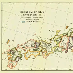
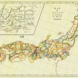
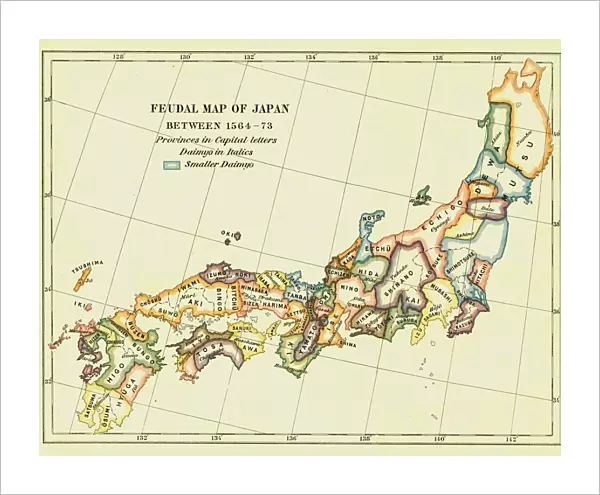
Fine Art Print : Feudal Map of Japan between 1564 -73, (1903). Creator: Unknown
. Creator: Unknown")

![]()
Fine Art Prints from Heritage Images
Feudal Map of Japan between 1564 -73, (1903). Creator: Unknown
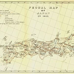
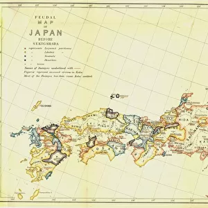
Feudal Map of Japan between 1564 -73, (1903). The feudal period of Japanese history was a time when powerful families (daimyo) and military warlords (shogun) ruled Japan. In 1543, a Portuguese trade ship landed introducing guns to Japanese society. From A History of Japan during the century of early foreign intercourse (1542-1651) by James Murdoch, M.A. and Isoh Yamagata. [Kobe, Japan, 1903]
Heritage Images features heritage image collections
Media ID 19667051
© The Print Collector/Heritage Images
Cartography Control Daimyo Division Edo Bakufu Feudal Feudalism Government Island Isoh Isoh Yamagata James Murdoch Jurisdiction Map Making Murdoch Murdoch James Pacific Ocean Portugal Portuguese Power Tokugawa Bakufu Tokugawa Shogunate Yamagata Yamagata Isoh
20"x16" (+3" Border) Fine Art Print
Step back in time with our exquisite Fine Art Print from Media Storehouse, featuring an intricately detailed Feudal Map of Japan between 1564-73. This captivating, vintage image, sourced from Heritage Images, showcases the political landscape of Japan during the feudal period. With powerful families (daimyo) and military warlords (shogun) ruling the land, this map offers a glimpse into a time of rich history and tradition. Add an air of sophistication and culture to your space with this beautiful, unknown creation. Note: Size not specified.
20x16 image printed on 26x22 Fine Art Rag Paper with 3" (76mm) white border. Our Fine Art Prints are printed on 300gsm 100% acid free, PH neutral paper with archival properties. This printing method is used by museums and art collections to exhibit photographs and art reproductions.
Our fine art prints are high-quality prints made using a paper called Photo Rag. This 100% cotton rag fibre paper is known for its exceptional image sharpness, rich colors, and high level of detail, making it a popular choice for professional photographers and artists. Photo rag paper is our clear recommendation for a fine art paper print. If you can afford to spend more on a higher quality paper, then Photo Rag is our clear recommendation for a fine art paper print.
Estimated Image Size (if not cropped) is 50.8cm x 40.6cm (20" x 16")
Estimated Product Size is 66cm x 55.9cm (26" x 22")
These are individually made so all sizes are approximate
Artwork printed orientated as per the preview above, with landscape (horizontal) orientation to match the source image.
FEATURES IN THESE COLLECTIONS
> Arts
> Artists
> O
> Oceanic Oceanic
> Asia
> Japan
> Related Images
> Europe
> Portugal
> Politics
> Europe
> Portugal
> Related Images
> Maps and Charts
> Early Maps
EDITORS COMMENTS
This print showcases a "Feudal Map of Japan between 1564-73" created in 1903 by an unknown artist. The image takes us back to the feudal period of Japanese history, a time when powerful families known as daimyo and military warlords called shogun held dominion over Japan. It was during this era that Portuguese traders arrived on Japanese shores in 1543, introducing firearms to the society. The map itself is a testament to the intricate cartography skills employed at the turn of the century. With vibrant colors and meticulous detail, it depicts the division of power and jurisdiction across various regions within Japan. From Edo Bakufu to Tokugawa Shogunate, each area represents a different seat of government during this tumultuous time. As we gaze upon this historical artifact, we are transported to an island nation grappling with political control and societal changes brought about by foreign influences. The map serves as both a visual representation of power dynamics and an invaluable resource for understanding Japan's rich past. Credit must be given to James Murdoch, M. A. , and Isoh Yamagata for their work titled "A History of Japan during the century of early foreign intercourse (1542-1651)". This collaboration from Kobe, Japan in 1903 sheds light on significant events that shaped Japanese history while also highlighting the artistry involved in map-making during that era.
MADE IN THE USA
Safe Shipping with 30 Day Money Back Guarantee
FREE PERSONALISATION*
We are proud to offer a range of customisation features including Personalised Captions, Color Filters and Picture Zoom Tools
SECURE PAYMENTS
We happily accept a wide range of payment options so you can pay for the things you need in the way that is most convenient for you
* Options may vary by product and licensing agreement. Zoomed Pictures can be adjusted in the Cart.