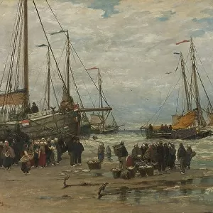
Fine Art Print > Arts > Watercolor paintings
Fine Art Print : General map of Suriname, 1737-1757. Creator: Hendrik de Leth


![]()
Fine Art Prints from Heritage Images
General map of Suriname, 1737-1757. Creator: Hendrik de Leth
General map of Suriname, 1737-1757. Map of the colony or province of Suriname: with the rivers, districts, discoveries by military expeditions and the size of the measured plantations / by burden'. Two sheets stuck together, showing the plantations on the various rivers. Left and right: columns with the names of the owners of the plantations, a total of 519. In the top left: map of the wider area. Left: Cartouche with the scale. At the top right: Cartouche with the title and the coat of arms of Suriname. (Surinam, also unofficially known as Dutch Guiana, was a Dutch plantation colony in South America)
Heritage Images features heritage image collections
Media ID 36351975
© Heritage Art/Heritage Images
Colony Imperialism Plantation Rivers Surinam Surinam South America Suriname South America Dutch Guiana Hendrik De Leth Plantations Suriname River Watercolour Paint
21"x14" (+3" Border) Fine Art Print
Discover the rich history of Suriname with this exquisite Fine Art Print from Media Storehouse. This rare and intriguing map, created by Hendrik de Leth in 1737-1757, offers a detailed and captivating view of the colony or province of Suriname during that period. With meticulous depictions of the rivers, districts, and plantations, this map provides a unique glimpse into the exploration and development of Suriname. The vibrant colors and intricate details of this Heritage Images print make it an essential addition to any historical or cartographic collection. Bring a piece of history into your home or office with this beautiful and informative Fine Art Print.
21x14 image printed on 27x20 Fine Art Rag Paper with 3" (76mm) white border. Our Fine Art Prints are printed on 300gsm 100% acid free, PH neutral paper with archival properties. This printing method is used by museums and art collections to exhibit photographs and art reproductions.
Our fine art prints are high-quality prints made using a paper called Photo Rag. This 100% cotton rag fibre paper is known for its exceptional image sharpness, rich colors, and high level of detail, making it a popular choice for professional photographers and artists. Photo rag paper is our clear recommendation for a fine art paper print. If you can afford to spend more on a higher quality paper, then Photo Rag is our clear recommendation for a fine art paper print.
Estimated Image Size (if not cropped) is 53.3cm x 35.5cm (21" x 14")
Estimated Product Size is 68.6cm x 50.8cm (27" x 20")
These are individually made so all sizes are approximate
Artwork printed orientated as per the preview above, with landscape (horizontal) orientation to match the source image.
FEATURES IN THESE COLLECTIONS
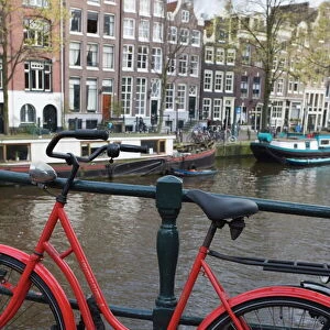
> Europe
> Netherlands
> Maps
> Europe
> Netherlands
> Posters
> Europe
> Netherlands
> Related Images
> Europe
> Netherlands
> Rivers
> Historic
> Colonial America illustrations
> 18th century America
> Historic
> Colonial America illustrations
> Colonial America
> Maps and Charts
> Netherlands
> Maps and Charts
> Related Images
EDITORS COMMENTS
This stunning 18th-century map print, titled "Map of the colony or province of Suriname: with the rivers, districts, discoveries by military expeditions and the size of the measured plantations," was created by the renowned Dutch cartographer Hendrik de Leth between 1737 and 1757. The map, which consists of two sheets joined together, offers a detailed representation of Suriname, a Dutch plantation colony located in South America. The map meticulously illustrates the various rivers, districts, and plantations in the region. The left side of the map features a column with the names of the plantation owners, totaling 519. The right side includes a wider area map and a cartouche displaying the title and the coat of arms of Suriname. The top left corner of the map showcases a map of the wider area, while the top right corner features a cartouche with the scale. The map is a testament to the Dutch colonial expansion in South America during the 18th century, a period marked by intense agricultural activity and the exploitation of natural resources. The intricate detail of the map is evident in the depiction of the geographical features, including the winding rivers and the coastal areas. The use of watercolor paint adds a richness and depth to the map, making it a valuable piece of heritage art. The map is a significant historical document, offering insights into the colonial history of Suriname and the Dutch presence in South America during the 18th century. This map is a must-have for collectors of historical maps, art enthusiasts, and anyone interested in the history of colonialism and imperialism. It is a beautiful addition to any home or office, and a fascinating glimpse into the past.
MADE IN THE USA
Safe Shipping with 30 Day Money Back Guarantee
FREE PERSONALISATION*
We are proud to offer a range of customisation features including Personalised Captions, Color Filters and Picture Zoom Tools
SECURE PAYMENTS
We happily accept a wide range of payment options so you can pay for the things you need in the way that is most convenient for you
* Options may vary by product and licensing agreement. Zoomed Pictures can be adjusted in the Cart.