Fine Art Print > Europe > France > Canton > Landes
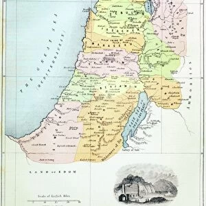
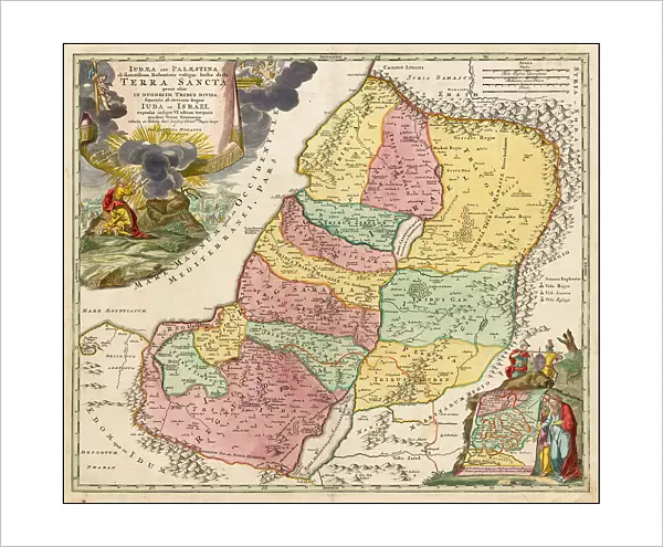
Fine Art Print : Map of the Holy Land Divided into the Twelve Tribes of Israel, c. 1710. Creator: Homann, Johann Baptist (1663-1724)
")

![]()
Fine Art Prints from Heritage Images
Map of the Holy Land Divided into the Twelve Tribes of Israel, c. 1710. Creator: Homann, Johann Baptist (1663-1724)
Map of the Holy Land Divided into the Twelve Tribes of Israel, c. 1710. Private Collection
Heritage Images features heritage image collections
Media ID 36250955
© Fine Art Images/Heritage Images
Cartography Copper Engraving Watercolour Homann Israel Johann Baptist 1663 1724 Judaism Tanach Tanakh Twelve Tribes Of Israel Copper Engraving Old Testament
20"x16" (+3" Border) Fine Art Print
Discover the rich history of the Holy Land with this exquisite Fine Art Print from Media Storehouse. This detailed map, created by renowned cartographer Johann Baptist Homann in around 1710, divides the Holy Land into the Twelve Tribes of Israel. A beautiful and intriguing representation of biblical history, this print is a must-have for any collection focusing on religious art or cartography. Meticulously reproduced from the original at Heritage Images, this print brings the past to life with its vivid colors and intricate details. Add a touch of history and spirituality to your home or office with this stunning Fine Art Print from Media Storehouse.
20x16 image printed on 26x22 Fine Art Rag Paper with 3" (76mm) white border. Our Fine Art Prints are printed on 300gsm 100% acid free, PH neutral paper with archival properties. This printing method is used by museums and art collections to exhibit photographs and art reproductions.
Our fine art prints are high-quality prints made using a paper called Photo Rag. This 100% cotton rag fibre paper is known for its exceptional image sharpness, rich colors, and high level of detail, making it a popular choice for professional photographers and artists. Photo rag paper is our clear recommendation for a fine art paper print. If you can afford to spend more on a higher quality paper, then Photo Rag is our clear recommendation for a fine art paper print.
Estimated Image Size (if not cropped) is 47.2cm x 40.6cm (18.6" x 16")
Estimated Product Size is 66cm x 55.9cm (26" x 22")
These are individually made so all sizes are approximate
Artwork printed orientated as per the preview above, with landscape (horizontal) orientation to match the source image.
FEATURES IN THESE COLLECTIONS
> Asia
> Israel
> Related Images
> Europe
> France
> Canton
> Landes
> Maps and Charts
> Related Images
EDITORS COMMENTS
This exquisite map, titled "Palestina Sacra" or "Sacred Palestine," is a stunning example of cartographic art from the early 18th century. Created by the renowned German cartographer Johann Baptist Homann (1663-1724), this masterpiece dates back to approximately 1710. The map is a meticulously detailed representation of the Holy Land, divided into the twelve tribes of Israel as described in the Old Testament. Homann's "Map of the Holy Land Divided into the Twelve Tribes of Israel" is a testament to the rich history and religious significance of the region. The map is a beautiful fusion of cartography, fine art, and biblical history. The intricate copper engraving is further enhanced by delicate watercolor, adding depth and texture to the landscape. The map is not just a geographical representation but a visual interpretation of the biblical narrative. Each tribe is identified by its name, with the boundaries marked by precise lines and topographical features. The map also includes various points of interest, such as cities, mountains, and bodies of water, further enhancing its historical and educational value. The map reflects the European fascination with the Holy Land during this period, as well as the importance of biblical knowledge in shaping cultural and intellectual discourse. Homann's "Map of the Holy Land Divided into the Twelve Tribes of Israel" is a significant work of art and a valuable historical artifact, offering a unique perspective on the biblical narrative and the historical context of the Middle East during the early modern period.
MADE IN THE USA
Safe Shipping with 30 Day Money Back Guarantee
FREE PERSONALISATION*
We are proud to offer a range of customisation features including Personalised Captions, Color Filters and Picture Zoom Tools
SECURE PAYMENTS
We happily accept a wide range of payment options so you can pay for the things you need in the way that is most convenient for you
* Options may vary by product and licensing agreement. Zoomed Pictures can be adjusted in the Cart.