Fine Art Print > Africa > Egypt > Maps
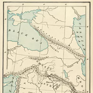
Fine Art Print : Map to Illustrate the Mesopotamian Expedition, 1919. Creator: George Philip & Son Ltd


![]()
Fine Art Prints from Heritage Images
Map to Illustrate the Mesopotamian Expedition, 1919. Creator: George Philip & Son Ltd
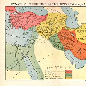
Map to Illustrate the Mesopotamian Expedition, 1919. Showing the Middle Eastern theatre of World War I, including the Turkish or Ottoman Empire, and parts of Russia, Persia and Egypt. The Mesopotamian campaign was fought between the Allies represented by the British Empire, (Britain, Australia and British India), and the Central Powers, mostly of the Ottoman Empire. From " The History of the Great European War: its causes and effects", Vol. V, by W. Stanley Macbean Knight. [Caxton Pulishing Company, Limited, London, 1919]
Heritage Images features heritage image collections
Media ID 19047861
© The Print Collector/Heritage Images
And Son Ltd Arabia Black Sea Caspian Sea Caxton Publishing Company Caxton Pulishing Company Caxton Pulishing Company Lim Caxton Pulishing Company Limited Caxton Pulishing Company Ltd George Philip And Son George Philip And Son Ltd Iran Iraq Knight Lebanon Limited Mediterranean Mesopotamia Mesopotamian Mesopotamien Ottoman Empire Palestine Persia Philip Sinai Stanley Macbean Stanley Macbean Knight Syria Theatre Of War Turkey W Stanley Macbean W Stanley Macbean Knight William Stanley Macbean William Stanley Macbean Knight Mizraim
20"x16" (+3" Border) Fine Art Print
Step back in time with our exquisite Fine Art Print from Media Storehouse, featuring the captivating Map to Illustrate the Mesopotamian Expedition of 1919. This stunning vintage map, created by George Philip & Son Ltd and sourced from Heritage Images, offers a captivating glimpse into the Middle Eastern theatre of World War I. Explore the intricate details of the Turkish or Ottoman Empire, Russia, Persia, and Egypt as they were depicted during this pivotal historical moment. Add an air of sophistication and historical depth to your home or office with this beautiful, museum-quality print.
20x16 image printed on 26x22 Fine Art Rag Paper with 3" (76mm) white border. Our Fine Art Prints are printed on 300gsm 100% acid free, PH neutral paper with archival properties. This printing method is used by museums and art collections to exhibit photographs and art reproductions.
Our fine art prints are high-quality prints made using a paper called Photo Rag. This 100% cotton rag fibre paper is known for its exceptional image sharpness, rich colors, and high level of detail, making it a popular choice for professional photographers and artists. Photo rag paper is our clear recommendation for a fine art paper print. If you can afford to spend more on a higher quality paper, then Photo Rag is our clear recommendation for a fine art paper print.
Estimated Image Size (if not cropped) is 50.8cm x 36.2cm (20" x 14.3")
Estimated Product Size is 66cm x 55.9cm (26" x 22")
These are individually made so all sizes are approximate
Artwork printed orientated as per the preview above, with landscape (horizontal) orientation to match the source image.
FEATURES IN THESE COLLECTIONS
> Arts
> Artists
> C
> William Caxton
> Arts
> Artists
> S
> Syrian Syrian
> Asia
> India
> Related Images
> Asia
> Iran
> Lakes
> Caspian Sea
> Asia
> Iran
> Related Images
> Asia
> Iraq
> Related Images
EDITORS COMMENTS
This print showcases a historical map titled "Map to Illustrate the Mesopotamian Expedition, 1919". Created by George Philip & Son Ltd, this intricate map provides a comprehensive overview of the Middle Eastern theater during World War I. The map encompasses various regions including the Turkish or Ottoman Empire, parts of Russia, Persia, and Egypt. The Mesopotamian campaign depicted in this map was fought between the Allies represented by the British Empire (Britain, Australia, and British India) and the Central Powers primarily from the Ottoman Empire. It serves as a visual representation of one of the significant conflicts that took place during this tumultuous period in history. Taken from "The History of the Great European War: its causes and effects". Vol. V by W. Stanley Macbean Knight and published by Caxton Publishing Company Limited in London in 1919, this print offers an invaluable glimpse into past geopolitical dynamics. With its vibrant colors and meticulous detailing, this image transports us back to a time when nations clashed on these very lands. From coastlines along the Mediterranean Sea to territories bordering Iran and Iraq; from Sinai Peninsula to Palestine; from Lebanon to Syria - every geographical feature is meticulously captured on this remarkable piece. As we delve into history through this mesmerizing photograph print, we are reminded of how wars shape nations while also appreciating cartographic artistry at its finest.
MADE IN THE USA
Safe Shipping with 30 Day Money Back Guarantee
FREE PERSONALISATION*
We are proud to offer a range of customisation features including Personalised Captions, Color Filters and Picture Zoom Tools
SECURE PAYMENTS
We happily accept a wide range of payment options so you can pay for the things you need in the way that is most convenient for you
* Options may vary by product and licensing agreement. Zoomed Pictures can be adjusted in the Cart.