Fine Art Print > Europe > Sweden > Maps
Fine Art Print : Map of Prussia, c1872. Creator: Unknown


![]()
Fine Art Prints from Heritage Images
Map of Prussia, c1872. Creator: Unknown
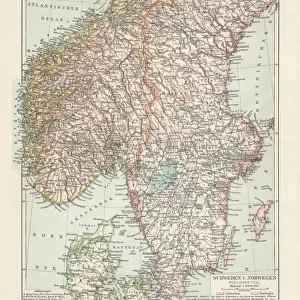
Map of Prussia, c1872. Showing the various regions including Holstein, Hanover, Westphalia, Lower Rhine, Lorraine, Nassau, Cassel, Saxony, Brandedburg, Silesia, Pomerania, West Prussia, East Prussia and Posen. From " The Franco-Prussian War: its causes, incidents and consequences", Volume I, by Captain H M Hozier. [William Mackenzie, London, 1872]
Heritage Images features heritage image collections
Media ID 19780443
© The Print Collector/Heritage Images
1870 1871 Baltic Sea Coastline Franco Prussian War H M Hozier Henry Montague Henry Montague Hozier Hozier Mackenzie North Sea Prussia Prussian Sir Henry Montagu Hozier Territorial Territory William Mackenzie Jutland
20"x16" (+3" Border) Fine Art Print
Discover the rich history of Europe with our exquisite selection of Fine Art Prints from Media Storehouse. This captivating Map of Prussia, dated c1872, showcases the intricate details of the regions that once formed the powerful German state. Explore the borders of Holstein, Hanover, Westphalia, Lower Rhine, Lorraine, Nassau, Cassel, Saxony, Brandenburg, Silesia, Pomerania, and West Prussia. Each print is meticulously sourced from Heritage Images and brings a piece of historical art into your home or office. Add this stunning Map of Prussia to your collection and transport yourself back in time.
20x16 image printed on 26x22 Fine Art Rag Paper with 3" (76mm) white border. Our Fine Art Prints are printed on 300gsm 100% acid free, PH neutral paper with archival properties. This printing method is used by museums and art collections to exhibit photographs and art reproductions.
Our fine art prints are high-quality prints made using a paper called Photo Rag. This 100% cotton rag fibre paper is known for its exceptional image sharpness, rich colors, and high level of detail, making it a popular choice for professional photographers and artists. Photo rag paper is our clear recommendation for a fine art paper print. If you can afford to spend more on a higher quality paper, then Photo Rag is our clear recommendation for a fine art paper print.
Estimated Image Size (if not cropped) is 50.8cm x 40.6cm (20" x 16")
Estimated Product Size is 66cm x 55.9cm (26" x 22")
These are individually made so all sizes are approximate
Artwork printed orientated as per the preview above, with landscape (horizontal) orientation to match the source image.
FEATURES IN THESE COLLECTIONS
> Europe
> Sweden
> Related Images
> Maps and Charts
> Related Images
EDITORS COMMENTS
This print showcases a detailed "Map of Prussia" from the year 1872, created by an unknown artist. The map provides a comprehensive view of the various regions within Prussia during that time period, including Holstein, Hanover, Westphalia, Lower Rhine, Lorraine, Nassau, Cassel, Saxony, Brandedburg, Silesia, Pomerania, West Prussia, East Prussia and Posen. It is sourced from Captain H M Hozier's book titled "The Franco-Prussian War: its causes incidents and consequences", Volume I. The map not only highlights the territorial boundaries but also emphasizes the coastal areas along Germany's coastline on both the North Sea and Baltic Sea. With vibrant colors and intricate details representing geographical features such as rivers and mountains; this 19th-century map offers a fascinating glimpse into Prussian history. As we delve into this historical artifact capturing a significant era in European history marked by conflicts like the Franco-Prussian War (1870-1871), it becomes evident how crucial maps were for understanding strategic locations during times of war. This particular print serves as a valuable resource for researchers studying territorial changes and geopolitical dynamics in Central Europe during that period. Preserved by The Print Collector under their vast collection encompassing diverse subjects beyond commercial use limitations; this remarkable piece allows us to appreciate Sir Henry Montagu Hozier's contribution to cartography through his publication with William Mackenzie in London back in
MADE IN THE USA
Safe Shipping with 30 Day Money Back Guarantee
FREE PERSONALISATION*
We are proud to offer a range of customisation features including Personalised Captions, Color Filters and Picture Zoom Tools
SECURE PAYMENTS
We happily accept a wide range of payment options so you can pay for the things you need in the way that is most convenient for you
* Options may vary by product and licensing agreement. Zoomed Pictures can be adjusted in the Cart.