Fine Art Print > Arts > Artists > O > Abraham Ortelius
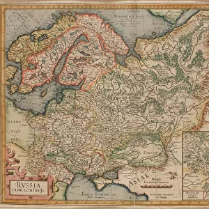
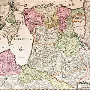
Fine Art Print : Map of Russia (From: Theatrum Orbis Terrarum), 1573. Artist: Ortelius, Abraham (1527-1598)
, 1573. Artist: Ortelius, Abraham (1527-1598)")


![]()
Fine Art Prints from Heritage Images
Map of Russia (From: Theatrum Orbis Terrarum), 1573. Artist: Ortelius, Abraham (1527-1598)
Map of Russia (From: Theatrum Orbis Terrarum), 1573. From a private collection
Heritage Images features heritage image collections
Media ID 15013214
© Fine Art Images
Abraham 1527 1598 Cartography Early Rus Grand Duchy Of Moscow History Of Russia Moscow Principality Muscovy Ortelius Russian History The Netherlands Theatrum Orbis Terrarum Copper Engraving
20"x16" (+3" Border) Fine Art Print
Discover the rich history of cartography with our exquisite Fine Art Print of the Map of Russia from Theatrum Orbis Terrarum, created by the renowned Flemish cartographer Abraham Ortelius in 1573. This rare and intricately detailed map, from a private collection, showcases the expansive territories of Russia as they were known during the Renaissance period. Bring a piece of historical cartography into your home or office and add an air of sophistication with this stunning Fine Art Print from Media Storehouse.
20x16 image printed on 26x22 Fine Art Rag Paper with 3" (76mm) white border. Our Fine Art Prints are printed on 300gsm 100% acid free, PH neutral paper with archival properties. This printing method is used by museums and art collections to exhibit photographs and art reproductions.
Our fine art prints are high-quality prints made using a paper called Photo Rag. This 100% cotton rag fibre paper is known for its exceptional image sharpness, rich colors, and high level of detail, making it a popular choice for professional photographers and artists. Photo rag paper is our clear recommendation for a fine art paper print. If you can afford to spend more on a higher quality paper, then Photo Rag is our clear recommendation for a fine art paper print.
Estimated Image Size (if not cropped) is 50.8cm x 40.6cm (20" x 16")
Estimated Product Size is 66cm x 55.9cm (26" x 22")
These are individually made so all sizes are approximate
Artwork printed orientated as per the preview above, with landscape (horizontal) orientation to match the source image.
FEATURES IN THESE COLLECTIONS
> Arts
> Artists
> O
> Abraham Ortelius
> Europe
> Netherlands
> Maps
> Europe
> Netherlands
> Posters
> Europe
> Netherlands
> Related Images
> Maps and Charts
> Abraham Ortelius
> Maps and Charts
> Early Maps
> Maps and Charts
> Netherlands
EDITORS COMMENTS
This print showcases a historic map of Russia, created by the talented artist Abraham Ortelius in 1573. The intricate details and exquisite craftsmanship of this copper engraving truly bring to life the rich history and cultural significance of Russia during the Middle Ages. The map highlights various regions within Russia, including Muscovy, Moscow Principality, and Grand Duchy of Moscow. It offers a fascinating glimpse into the early Rus period, providing valuable insights into the country's past. Ortelius' expertise in cartography is evident in this masterpiece as he skillfully combines accuracy with artistic flair. The delicate watercolor touches add depth and vibrancy to each element on the map, making it an exceptional piece of fine art. Hailing from Theatrum Orbis Terrarum collection, this rare gem holds immense historical value. Its presence in a private collection further enhances its exclusivity and allure. As we gaze upon this remarkable image, we are transported back in time to explore Russian history through Ortelius' eyes. This print serves as a testament to his talent as well as a reminder of how maps have played an integral role in shaping our understanding of different cultures throughout centuries.
MADE IN THE USA
Safe Shipping with 30 Day Money Back Guarantee
FREE PERSONALISATION*
We are proud to offer a range of customisation features including Personalised Captions, Color Filters and Picture Zoom Tools
SECURE PAYMENTS
We happily accept a wide range of payment options so you can pay for the things you need in the way that is most convenient for you
* Options may vary by product and licensing agreement. Zoomed Pictures can be adjusted in the Cart.