Fine Art Print > Asia > Mongolia > Maps
Fine Art Print : Map of Siberia


![]()
Fine Art Prints from Heritage Images
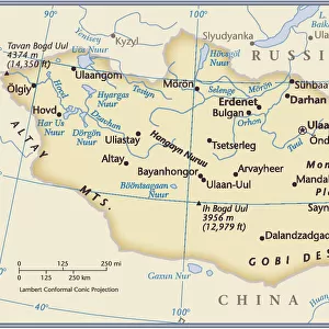
Map of Siberia
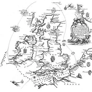
Map of Siberia. Map showing eastern Russia, Mongolia, the Sea of Okhotsk and the Kamchatka Peninsula. Plate 67 from The Times Atlas
Heritage Images features heritage image collections
Media ID 15464456
© The Print Collector / Heritage-Images
Arctic Circle Cartography Coastline Kamchatka Peninsula Map Making Mongolia Peninsula Sea Of Okhotsk Siberia
20"x16" (+3" Border) Fine Art Print
Discover the captivating beauty of Siberia with our exquisite Fine Art Print from Media Storehouse, featuring a detailed map extracted from The Times Atlas. This stunning representation showcases Eastern Russia, Mongolia, the Sea of Okhotsk, and the Kamchatka Peninsula. Each print is meticulously produced using high-quality materials, ensuring vibrant colors and sharp details. Bring the intrigue of Siberia into your home or office with this beautiful and educational piece of art.
20x16 image printed on 26x22 Fine Art Rag Paper with 3" (76mm) white border. Our Fine Art Prints are printed on 300gsm 100% acid free, PH neutral paper with archival properties. This printing method is used by museums and art collections to exhibit photographs and art reproductions.
Our fine art prints are high-quality prints made using a paper called Photo Rag. This 100% cotton rag fibre paper is known for its exceptional image sharpness, rich colors, and high level of detail, making it a popular choice for professional photographers and artists. Photo rag paper is our clear recommendation for a fine art paper print. If you can afford to spend more on a higher quality paper, then Photo Rag is our clear recommendation for a fine art paper print.
Estimated Image Size (if not cropped) is 50.8cm x 40.6cm (20" x 16")
Estimated Product Size is 66cm x 55.9cm (26" x 22")
These are individually made so all sizes are approximate
Artwork printed orientated as per the preview above, with landscape (horizontal) orientation to match the source image.
FEATURES IN THESE COLLECTIONS
> Asia
> Mongolia
> Related Images
> Europe
> Russia
> Related Images
> Maps and Charts
> Related Images
EDITORS COMMENTS
This print showcases a meticulously detailed "Map of Siberia" that takes us on an enchanting journey through the vast and mysterious lands of eastern Russia. With its vibrant colors and intricate cartography, this map offers a fascinating glimpse into the geographical features that define this remote region. Stretching from the Arctic Circle to Mongolia, it encompasses breathtaking coastlines along the Sea of Okhotsk and culminates in the awe-inspiring Kamchatka Peninsula. Every contour is carefully delineated, allowing us to appreciate the sheer magnitude of Siberia's expansive territory. As we explore this map, we are transported to a world where unknown wonders await discovery. It serves as both a testament to human ingenuity in map-making and an invitation for intrepid explorers to venture forth into uncharted territories. The attention to detail is remarkable; every country, every peninsula is meticulously labeled with precision. This print not only captures our imagination but also provides valuable geographic information about this enigmatic part of our planet. With its rich history and diverse landscapes, Siberia beckons adventurers seeking untamed wildernesses and unparalleled beauty. Whether you're drawn by its rugged coastline or intrigued by its vast expanses, this stunning map print will surely ignite your wanderlust and inspire dreams of embarking on epic journeys across these majestic lands.
MADE IN THE USA
Safe Shipping with 30 Day Money Back Guarantee
FREE PERSONALISATION*
We are proud to offer a range of customisation features including Personalised Captions, Color Filters and Picture Zoom Tools
SECURE PAYMENTS
We happily accept a wide range of payment options so you can pay for the things you need in the way that is most convenient for you
* Options may vary by product and licensing agreement. Zoomed Pictures can be adjusted in the Cart.