Fine Art Print > Animals > Mammals > Soricidae > Navigator
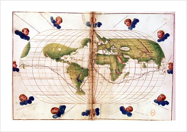
Fine Art Print : Map of Magellans round the world voyage, 1519-1521


![]()
Fine Art Prints from Heritage Images
Map of Magellans round the world voyage, 1519-1521
Map of Magellans round the world voyage, 1519-1521. A Portuguese-born navigator sponsored by Spain, Ferdinand Magellan (c1480-1521) led the expedition that made the first circumnavigation of the globe. This Mercator projection map shows the route taken, which included the first passage through the straits at the southern tip of South America that bear Magellans name. Magellan did not himself complete the voyage, as he was killed in the Philippines in a clash with natives. Of the five ships that set out from Spain in 1519, only one, the Victoria, commanded by Juan de Elcano, returned safely. From the Bibliotheque Nationale, Paris
Heritage Images features heritage image collections
Media ID 14847398
© Ann Ronan Picture Library / Heritage-Images
Accomplishment Achievement Cartography Chart Circumnavigation Discovery Exploration Ferdinand Magellan Fernando Journey Magellan Map Making Navigation Pioneer Route Straits Of Magellan Success Voyage World Ann Ronan Pictures Fernao Magalhaes Mercator Projection
21"x14" (+3" Border) Fine Art Print
Discover the rich history of exploration with our exquisite Fine Art Print of Magellan's Map of the World, circa 1519-1521. This rare and captivating piece, from the Heritage Images archive, illustrates the groundbreaking journey led by Portuguese navigator Ferdinand Magellan, sponsored by Spain. The map showcases the first recorded circumnavigation of the globe, a testament to human curiosity and the spirit of adventure. Bring this piece of history into your home or office and let it inspire and intrigue all who see it.
21x14 image printed on 27x20 Fine Art Rag Paper with 3" (76mm) white border. Our Fine Art Prints are printed on 300gsm 100% acid free, PH neutral paper with archival properties. This printing method is used by museums and art collections to exhibit photographs and art reproductions.
Our fine art prints are high-quality prints made using a paper called Photo Rag. This 100% cotton rag fibre paper is known for its exceptional image sharpness, rich colors, and high level of detail, making it a popular choice for professional photographers and artists. Photo rag paper is our clear recommendation for a fine art paper print. If you can afford to spend more on a higher quality paper, then Photo Rag is our clear recommendation for a fine art paper print.
Estimated Image Size (if not cropped) is 53.3cm x 35.5cm (21" x 14")
Estimated Product Size is 68.6cm x 50.8cm (27" x 20")
These are individually made so all sizes are approximate
Artwork printed orientated as per the preview above, with landscape (horizontal) orientation to match the source image.
FEATURES IN THESE COLLECTIONS
> Animals
> Mammals
> Soricidae
> Navigator
> Asia
> Philippines
> Maps
> Asia
> Philippines
> Related Images
> Europe
> France
> Paris
> Maps
> Europe
> Portugal
> Related Images
> Europe
> Spain
> Related Images
> Heritage Images
> Maps Charts & Plans
EDITORS COMMENTS
This print showcases a historic map of Ferdinand Magellan's groundbreaking voyage around the world from 1519 to 1521. As a Portuguese-born navigator sponsored by Spain, Magellan led an expedition that achieved the remarkable feat of circumnavigating the globe for the first time in history. The Mercator projection map vividly depicts the route taken by Magellan and his crew, highlighting their monumental achievement of being the first to navigate through the straits at the southern tip of South America, now known as Magellan's Straits. Tragically, Magellan himself did not witness the completion of this momentous journey as he lost his life during a clash with natives in the Philippines. Despite this setback, one ship out of five that departed from Spain in 1519 managed to return safely. Commanded by Juan de Elcano, the Victoria became a symbol of triumph and resilience. This beautifully detailed print is sourced from Bibliotheque Nationale in Paris and provides an intriguing glimpse into early cartography and exploration. It serves as a testament to human curiosity and determination to conquer new frontiers during this era of discovery. The vibrant colors on this sixteenth-century map capture both our fascination with geography and our admiration for those pioneers who dared to venture into uncharted territories.
MADE IN THE USA
Safe Shipping with 30 Day Money Back Guarantee
FREE PERSONALISATION*
We are proud to offer a range of customisation features including Personalised Captions, Color Filters and Picture Zoom Tools
SECURE PAYMENTS
We happily accept a wide range of payment options so you can pay for the things you need in the way that is most convenient for you
* Options may vary by product and licensing agreement. Zoomed Pictures can be adjusted in the Cart.