Fine Art Print > South America > Chile > Maps
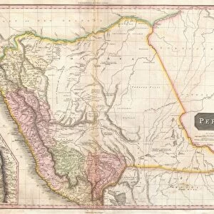
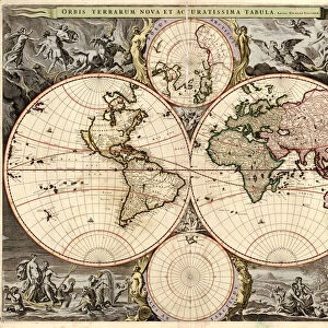
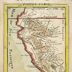
Fine Art Print : Map of Peru, c1599. Artist: Arnoldus Florentius


![]()
Fine Art Prints from Heritage Images
Map of Peru, c1599. Artist: Arnoldus Florentius
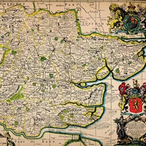
Map of Peru, c1599. A map of South America and the Caribbean, with Chile, Peru, Brazil, Cuba and Florida. From Adventures By Sea From Art of Old Time, by Basil Lubbock. [The Studio Ltd. London, 1925]
Heritage Images features heritage image collections
Media ID 14978633
© The Print Collector
Basil Basil Lubbock Cartography Lubbock Map Making Peru Arnoldus
20"x16" (+3" Border) Fine Art Print
Discover the rich history of the Americas with our exquisite Fine Art Print of the Map of Peru, c1599. This captivating antique map, created by Arnoldus Florentius in 1599, offers a fascinating glimpse into the geographical knowledge of the time. Depicting South America and the Caribbean, this detailed map showcases the early exploration of Chile, Peru, Brazil, Cuba, and Florida. Add an air of sophistication and historical intrigue to your space with this stunning, vintage print from Media Storehouse's Fine Art collection.
20x16 image printed on 26x22 Fine Art Rag Paper with 3" (76mm) white border. Our Fine Art Prints are printed on 300gsm 100% acid free, PH neutral paper with archival properties. This printing method is used by museums and art collections to exhibit photographs and art reproductions.
Our fine art prints are high-quality prints made using a paper called Photo Rag. This 100% cotton rag fibre paper is known for its exceptional image sharpness, rich colors, and high level of detail, making it a popular choice for professional photographers and artists. Photo rag paper is our clear recommendation for a fine art paper print. If you can afford to spend more on a higher quality paper, then Photo Rag is our clear recommendation for a fine art paper print.
Estimated Image Size (if not cropped) is 50.8cm x 35.5cm (20" x 14")
Estimated Product Size is 66cm x 55.9cm (26" x 22")
These are individually made so all sizes are approximate
Artwork printed orientated as per the preview above, with landscape (horizontal) orientation to match the source image.
FEATURES IN THESE COLLECTIONS
> Maps and Charts
> Related Images
> North America
> Cuba
> Maps
> North America
> Cuba
> Related Images
> South America
> Brazil
> Maps
> South America
> Brazil
> Related Images
> South America
> Chile
> Maps
> South America
> Chile
> Related Images
> South America
> Peru
> Maps
> South America
> Peru
> Related Images
> Heritage Images
> Maps Charts & Plans
EDITORS COMMENTS
This print showcases a remarkable piece of cartographic history - the "Map of Peru, c1599" by Arnoldus Florentius. Created during the 16th century, this map offers a fascinating glimpse into the geographical knowledge and artistic skills of that era. The intricate details and vibrant colors bring to life South America and the Caribbean region, including Chile, Peru, Brazil, Cuba, and Florida. It is an invaluable resource for understanding how these areas were perceived in the past. As we delve into this historical artifact from "Adventures By Sea From Art of Old Time" authored by Basil Lubbock in 1925, we are transported back in time. The careful craftsmanship evident in every stroke reveals Florentius' dedication to accuracy and his mastery as a cartographer. This print not only serves as a visual delight but also provides valuable insights into the evolution of map-making techniques over centuries. It reminds us of our ancestors' thirst for exploration and their relentless pursuit to chart unknown territories accurately. Preserved with utmost care by The Print Collector29 at The Studio Ltd. , London; it stands as a testament to their commitment to preserving our rich cultural heritage. Let this magnificent artwork transport you through time as you marvel at its beauty while appreciating its significance in shaping our understanding of geography throughout history.
MADE IN THE USA
Safe Shipping with 30 Day Money Back Guarantee
FREE PERSONALISATION*
We are proud to offer a range of customisation features including Personalised Captions, Color Filters and Picture Zoom Tools
SECURE PAYMENTS
We happily accept a wide range of payment options so you can pay for the things you need in the way that is most convenient for you
* Options may vary by product and licensing agreement. Zoomed Pictures can be adjusted in the Cart.