Fine Art Print > Europe > Austria > Maps
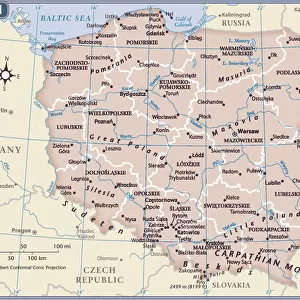
Fine Art Print : Poland and the Partitions of 1772, 1793 & 1795, (c1920). Creator: John Bartholomew & Son
. Creator: John Bartholomew & Son")

![]()
Fine Art Prints from Heritage Images
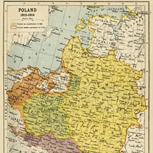
Poland and the Partitions of 1772, 1793 & 1795, (c1920). Creator: John Bartholomew & Son
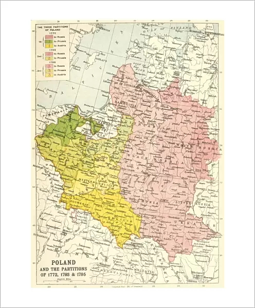
Poland and the Partitions of 1772, 1793 & 1795, (c1920). Map showing how territory in Europe was divided between the empires of Russia, Prussia and Austria in the 18th century. From " The Great World War - A History" Volume IV, edited by Frank A Mumby. [The Gresham Publishing Company Ltd, London, c1920]
Heritage Images features heritage image collections
Media ID 19174401
© The Print Collector/Heritage Images
Austro Hungarian Empire Baltic Sea Bartholomew Bartholomew And Co Bartholomew Co Bartholomew John Son Commonwealth Disputed Territory Frank Arthur Frank Arthur Mumby Galicia Gresham Publishing Co Ltd Gresham Publishing Company Imperial Imperialism Jg Bartholomew John And Son John Bartholomew And Co John Bartholomew And Son John Bartholomew And Son Ltd John Bartholomew Co John Bartholomew Son John Bartholomew Son Ltd John Son Keystone Archives Lithuania Mumby Mumby Frank Arthur Occupied Territory Partition Poland Prussia Prussian Territorial Territory The Great World War A History Theatre Of War Ukraine
20"x16" (+3" Border) Fine Art Print
Step back in time with this captivating Fine Art Print from Media Storehouse, showcasing the historical map of Poland and the Partitions of 1772, 1793, and 1795. Produced by renowned cartographers John Bartholomew & Son around 1920, this vintage map offers a unique perspective on European history. Witness the intricate details as territories once ruled by Poland are depicted being divided among Russia, Prussia, and Austria. This exquisite piece is not just a map, but a window into the past, perfect for history enthusiasts, educators, or anyone with an appreciation for the rich tapestry of our world's history.
20x16 image printed on 26x22 Fine Art Rag Paper with 3" (76mm) white border. Our Fine Art Prints are printed on 300gsm 100% acid free, PH neutral paper with archival properties. This printing method is used by museums and art collections to exhibit photographs and art reproductions.
Our fine art prints are high-quality prints made using a paper called Photo Rag. This 100% cotton rag fibre paper is known for its exceptional image sharpness, rich colors, and high level of detail, making it a popular choice for professional photographers and artists. Photo rag paper is our clear recommendation for a fine art paper print. If you can afford to spend more on a higher quality paper, then Photo Rag is our clear recommendation for a fine art paper print.
Estimated Image Size (if not cropped) is 36.7cm x 50.8cm (14.4" x 20")
Estimated Product Size is 55.9cm x 66cm (22" x 26")
These are individually made so all sizes are approximate
Artwork printed orientated as per the preview above, with portrait (vertical) orientation to match the source image.
FEATURES IN THESE COLLECTIONS
> Europe
> Austria
> Related Images
> Europe
> Hungary
> Related Images
> Europe
> Lithuania
> Posters
> Europe
> Lithuania
> Related Images
EDITORS COMMENTS
This print titled "Poland and the Partitions of 1772,1793 & 1795" showcases a historical map created by John Bartholomew & Son in the early 20th century. The map vividly illustrates how the European territories were divided among three powerful empires - Russia, Prussia, and Austria - during the tumultuous years of the late 18th century. The image provides valuable insights into a significant period in Polish history when Poland was partitioned multiple times. These partitions resulted in substantial territorial losses for Poland as neighboring empires sought to expand their influence and control over Eastern Europe. The intricate details on this colorized lithograph highlight disputed territories, coastal regions along the Baltic Sea, and geographical features such as Galicia and Lithuania. It serves as a visual representation of imperialistic ambitions prevalent during that era. Taken from "The Great World War - A History" edited by Frank A Mumby, this historic print offers viewers an opportunity to delve into the complex dynamics that shaped Europe before World War I. The craftsmanship of John Bartholomew & Son is evident through their meticulous cartography skills showcased in this remarkable piece. As we explore this photograph print today, it serves as a reminder of Poland's resilience throughout its turbulent past while also emphasizing how historical events continue to shape our world today.
MADE IN THE USA
Safe Shipping with 30 Day Money Back Guarantee
FREE PERSONALISATION*
We are proud to offer a range of customisation features including Personalised Captions, Color Filters and Picture Zoom Tools
SECURE PAYMENTS
We happily accept a wide range of payment options so you can pay for the things you need in the way that is most convenient for you
* Options may vary by product and licensing agreement. Zoomed Pictures can be adjusted in the Cart.