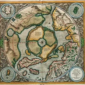
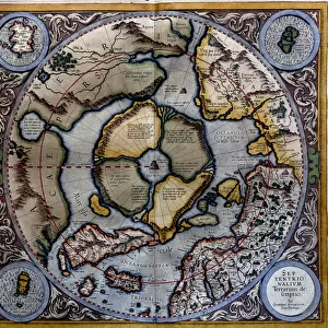
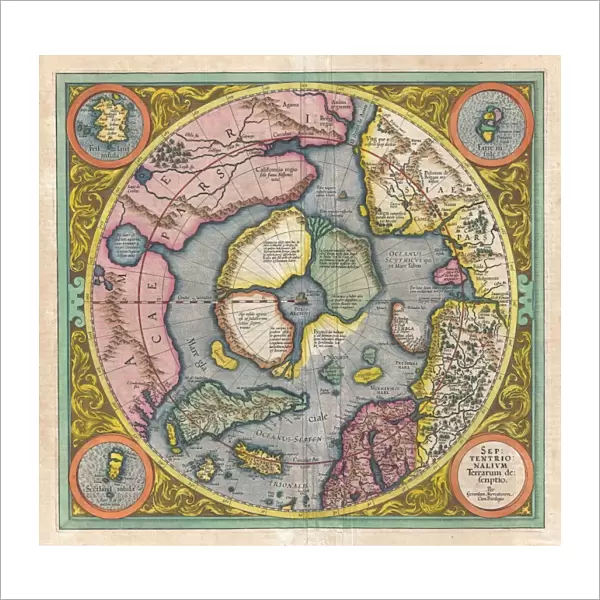
Fine Art Print : 1606, Mercator Hondius Map of the Arctic, First Map of the North Pole, topography

![]()
Fine Art Prints from Liszt Collection
1606, Mercator Hondius Map of the Arctic, First Map of the North Pole, topography
1606, Mercator Hondius Map of the Arctic, First Map of the North Pole
Liszt Collection of nineteenth-century engravings and images to browse and enjoy
Media ID 14004424
© Artokoloro Quint Lox Limited
1606 Antique Map Latitude Longitude Mappa Mundi Old Antique Plan Old Antique View Ols Antique Map Rare Old Maps Topo
20"x20" (+3" Border) Fine Art Print
Discover the fascinating history of cartography with our exquisite offering from the Media Storehouse Fine Art Prints collection. This rare and captivating piece showcases the 1606 Mercator Hondius Map of the Arctic, also known as the first map of the North Pole. Meticulously reproduced from the original map held in the prestigious Liszt Collection, this print showcases the intricate topography of the Arctic region as it was understood during the early 17th century. Bring a piece of cartographic history into your home or office and transport yourself back in time with this stunning work of art.
20x20 image printed on 26x26 Fine Art Rag Paper with 3" (76mm) white border. Our Fine Art Prints are printed on 300gsm 100% acid free, PH neutral paper with archival properties. This printing method is used by museums and art collections to exhibit photographs and art reproductions.
Our fine art prints are high-quality prints made using a paper called Photo Rag. This 100% cotton rag fibre paper is known for its exceptional image sharpness, rich colors, and high level of detail, making it a popular choice for professional photographers and artists. Photo rag paper is our clear recommendation for a fine art paper print. If you can afford to spend more on a higher quality paper, then Photo Rag is our clear recommendation for a fine art paper print.
Estimated Image Size (if not cropped) is 50.8cm x 47.8cm (20" x 18.8")
Estimated Product Size is 66cm x 66cm (26" x 26")
These are individually made so all sizes are approximate
Artwork printed orientated as per the preview above, with landscape (horizontal) orientation to match the source image.
EDITORS COMMENTS
This print showcases the remarkable 1606 Mercator Hondius Map of the Arctic, which holds the distinction of being the first map ever created of the North Pole. With its intricate topography and meticulous cartography, this historic artifact offers a fascinating glimpse into our understanding of geography during that era. The map's detailed illustration transports us back in time to an age when exploration and discovery were at their peak. Its carefully plotted grid lines, latitude and longitude markings, and geometric precision demonstrate the immense skill and knowledge possessed by early cartographers. As we gaze upon this vintage piece of art, we are reminded of how far humanity has come in unraveling the mysteries of our planet. The aged paper and retro aesthetic add a touch of nostalgia, evoking a sense of wonder for those who appreciate historical artifacts. This rare old map serves as a testament to human curiosity and ambition. It invites us on a journey through time while igniting our own desire for adventure and exploration. Whether used for educational purposes or simply admired as an exquisite decorative piece, this antique treasure from the Liszt Collection is sure to captivate all who encounter it.
MADE IN THE USA
Safe Shipping with 30 Day Money Back Guarantee
FREE PERSONALISATION*
We are proud to offer a range of customisation features including Personalised Captions, Color Filters and Picture Zoom Tools
SECURE PAYMENTS
We happily accept a wide range of payment options so you can pay for the things you need in the way that is most convenient for you
* Options may vary by product and licensing agreement. Zoomed Pictures can be adjusted in the Cart.