Fine Art Print > Europe > France > Canton > Landes
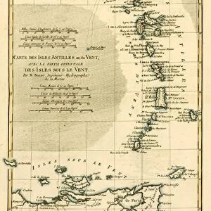
Fine Art Print : 1683, Mortier Map of North America, the West Indies, and the Atlantic Ocean, topography


![]()
Fine Art Prints from Liszt Collection
1683, Mortier Map of North America, the West Indies, and the Atlantic Ocean, topography
1683, Mortier Map of North America, the West Indies, and the Atlantic Ocean
Liszt Collection of nineteenth-century engravings and images to browse and enjoy
Media ID 14004459
© Artokoloro Quint Lox Limited
1683 Antique Map Latitude Longitude Mappa Mundi Old Antique Plan Old Antique View Ols Antique Map Rare Old Maps Topo
20"x16" (+3" Border) Fine Art Print
Discover history through the lens of exquisite cartography with our Fine Art Print of the 1683 Mortier Map of North America, the West Indies, and the Atlantic Ocean. This rare and intricately detailed map, hailing from the esteemed Liszt Collection, offers a captivating glimpse into the geographic knowledge of the time. With its rich, vibrant colors and meticulous topography, this Fine Art Print is not only a beautiful addition to any home or office, but also a fascinating conversation starter. Transport yourself back to the 17th century and explore the world as it was once known. Order now and bring a piece of history into your space.
20x16 image printed on 26x22 Fine Art Rag Paper with 3" (76mm) white border. Our Fine Art Prints are printed on 300gsm 100% acid free, PH neutral paper with archival properties. This printing method is used by museums and art collections to exhibit photographs and art reproductions.
Our fine art prints are high-quality prints made using a paper called Photo Rag. This 100% cotton rag fibre paper is known for its exceptional image sharpness, rich colors, and high level of detail, making it a popular choice for professional photographers and artists. Photo rag paper is our clear recommendation for a fine art paper print. If you can afford to spend more on a higher quality paper, then Photo Rag is our clear recommendation for a fine art paper print.
Estimated Image Size (if not cropped) is 50.8cm x 40.6cm (20" x 16")
Estimated Product Size is 66cm x 55.9cm (26" x 22")
These are individually made so all sizes are approximate
Artwork printed orientated as per the preview above, with landscape (horizontal) orientation to match the source image.
FEATURES IN THESE COLLECTIONS
> Arts
> Artists
> O
> Oceanic Oceanic
> Europe
> France
> Canton
> Landes
> Historic
> Space exploration
> Maps and Charts
> Early Maps
> Maps and Charts
> Related Images
> Maps and Charts
> World
EDITORS COMMENTS
This print showcases the 1683 Mortier Map of North America, the West Indies, and the Atlantic Ocean. With its intricate topography, this vintage map takes us back in time to an era of exploration and discovery. The artistry and attention to detail evident in this cartographic masterpiece are truly remarkable. The map's depiction of landforms, illustrated with precision and accuracy, allows us to visualize the geographical features that shaped these regions centuries ago. Its grid system based on latitude and longitude provides a navigational tool for adventurers seeking new frontiers. As we gaze upon this ancient artifact, we can't help but marvel at how it captures a snapshot of history frozen in time. The aged paper adds a touch of nostalgia while reminding us of the countless journeys made by explorers who relied on maps like these to navigate uncharted territories. This decorative piece serves as a window into our planet's past—a mappa mundi that reveals not only physical landscapes but also hints at cultural exchanges between different regions. It reminds us that even in an age where satellite imagery dominates our understanding of geography, there is still beauty and value in studying old antique maps like this one. Whether you're an avid collector or simply appreciate historical artifacts, this rare Mortier Map print offers a glimpse into a world long gone yet forever preserved through artful cartography.
MADE IN THE USA
Safe Shipping with 30 Day Money Back Guarantee
FREE PERSONALISATION*
We are proud to offer a range of customisation features including Personalised Captions, Color Filters and Picture Zoom Tools
SECURE PAYMENTS
We happily accept a wide range of payment options so you can pay for the things you need in the way that is most convenient for you
* Options may vary by product and licensing agreement. Zoomed Pictures can be adjusted in the Cart.