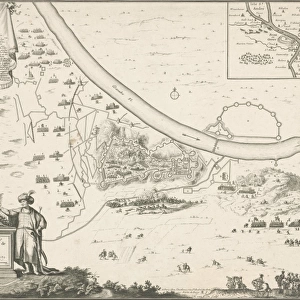
Fine Art Print : 1686, Mallet Map of Ceylon or Sri Lanka, Taprobane, topography, cartography, geography


![]()
Fine Art Prints from Liszt Collection
1686, Mallet Map of Ceylon or Sri Lanka, Taprobane, topography, cartography, geography
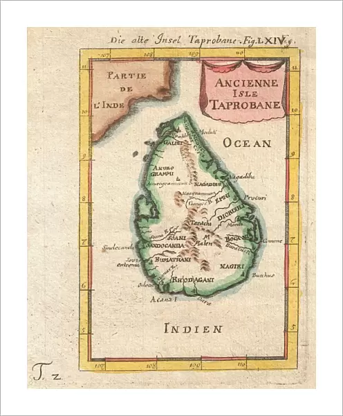
1686, Mallet Map of Ceylon or Sri Lanka, Taprobane
Liszt Collection of nineteenth-century engravings and images to browse and enjoy
Media ID 14004453
© Artokoloro Quint Lox Limited
1686 Antique Map Latitude Longitude Mappa Mundi Old Antique Plan Old Antique View Ols Antique Map Rare Old Maps Topo
20"x16" (+3" Border) Fine Art Print
Discover the rich history and geography of Sri Lanka with our exquisite Fine Art Print of the 1686 Mallet Map of Ceylon, also known as Taprobane. This rare and intricately detailed map, hailing from the renowned Liszt Collection, offers a captivating glimpse into the topography and cartography of Sri Lanka during the 17th century. Bring the intrigue and allure of ancient Ceylon into your home or office with this beautiful work of art, a timeless piece that tells a story of exploration and discovery.
20x16 image printed on 26x22 Fine Art Rag Paper with 3" (76mm) white border. Our Fine Art Prints are printed on 300gsm 100% acid free, PH neutral paper with archival properties. This printing method is used by museums and art collections to exhibit photographs and art reproductions.
Our fine art prints are high-quality prints made using a paper called Photo Rag. This 100% cotton rag fibre paper is known for its exceptional image sharpness, rich colors, and high level of detail, making it a popular choice for professional photographers and artists. Photo rag paper is our clear recommendation for a fine art paper print. If you can afford to spend more on a higher quality paper, then Photo Rag is our clear recommendation for a fine art paper print.
Estimated Image Size (if not cropped) is 40.6cm x 50.8cm (16" x 20")
Estimated Product Size is 55.9cm x 66cm (22" x 26")
These are individually made so all sizes are approximate
Artwork printed orientated as per the preview above, with portrait (vertical) orientation to match the source image.
EDITORS COMMENTS
This print showcases the intricate beauty of a 1686 Mallet Map of Ceylon, also known as Sri Lanka. The map, created by cartographer Allain Manesson Mallet, offers a mesmerizing glimpse into the topography and geography of this enchanting island nation. With its meticulous detail and artistic flair, this vintage map takes us on a journey through time, unraveling the rich history and ancient roots of Sri Lanka. The delicate lines and precise grid system reveal latitude and longitude coordinates, providing an accurate representation of the land's contours. As we gaze upon this historical artifact, we are transported to an era when exploration was at its peak. This decorative piece not only serves as a navigational tool but also evokes a sense of wonderment for those who appreciate artistry intertwined with geographic knowledge. The aged appearance adds to its charm, reminding us that it has witnessed centuries worth of discoveries and journeys across uncharted territories. It serves as a testament to human curiosity about our world's vast regions. Whether you are an avid collector or simply intrigued by ancient maps, this rare gem from the Liszt Collection is sure to captivate your imagination. Let it transport you back in time as you marvel at the beauty that lies within both nature's landscapes and mankind's ability to capture them on paper.
MADE IN THE USA
Safe Shipping with 30 Day Money Back Guarantee
FREE PERSONALISATION*
We are proud to offer a range of customisation features including Personalised Captions, Color Filters and Picture Zoom Tools
SECURE PAYMENTS
We happily accept a wide range of payment options so you can pay for the things you need in the way that is most convenient for you
* Options may vary by product and licensing agreement. Zoomed Pictures can be adjusted in the Cart.