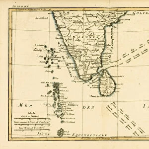
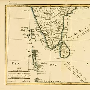
Fine Art Print : 1780, Bonne Map of Southern India, Ceylon, and the Maldives, Rigobert Bonne 1727 - 1794


![]()
Fine Art Prints from Liszt Collection
1780, Bonne Map of Southern India, Ceylon, and the Maldives, Rigobert Bonne 1727 - 1794
1780, Bonne Map of Southern India, Ceylon, and the Maldives, Rigobert Bonne 1727 - 1794, one of the most important cartographers of the late 18th century
Liszt Collection of nineteenth-century engravings and images to browse and enjoy
Media ID 14004753
© Artokoloro Quint Lox Limited
1780 Ceylon Rigobert Bonne 1727 1794 Rigobert Bonne 1727 – 1794 Rigobert Bonne 17271794 Antique Map Latitude Longitude Mappa Mundi Old Antique Plan Old Antique View Ols Antique Map Rare Old Maps Topo
21"x14" (+3" Border) Fine Art Print
Step back in time with our exquisite offering from the Media Storehouse Fine Art Prints collection. This rare and captivating map, titled "Carte de l'Inde Orientale et des Isles Adjacentes," was created by the renowned cartographer Rigobert Bonne in 1780. Depicting Southern India, Ceylon, and the Maldives, this detailed and intricately designed map is a testament to the cartographic mastery of the late 18th century. Originally from the esteemed Liszt Collection, this fine art print is a must-have for history enthusiasts, cartography aficionados, and anyone seeking to adorn their walls with a piece of historical significance. Bring the rich history of the Indian Ocean region into your home or office with this stunning, museum-quality print.
21x14 image printed on 27x20 Fine Art Rag Paper with 3" (76mm) white border. Our Fine Art Prints are printed on 300gsm 100% acid free, PH neutral paper with archival properties. This printing method is used by museums and art collections to exhibit photographs and art reproductions.
Our fine art prints are high-quality prints made using a paper called Photo Rag. This 100% cotton rag fibre paper is known for its exceptional image sharpness, rich colors, and high level of detail, making it a popular choice for professional photographers and artists. Photo rag paper is our clear recommendation for a fine art paper print. If you can afford to spend more on a higher quality paper, then Photo Rag is our clear recommendation for a fine art paper print.
Estimated Image Size (if not cropped) is 53.3cm x 35.5cm (21" x 14")
Estimated Product Size is 68.6cm x 50.8cm (27" x 20")
These are individually made so all sizes are approximate
Artwork printed orientated as per the preview above, with landscape (horizontal) orientation to match the source image.
EDITORS COMMENTS
This print showcases the remarkable "1780, Bonne Map of Southern India, Ceylon, and the Maldives" created by Rigobert Bonne (1727-1794), a renowned cartographer of the late 18th century. Bonne's expertise in topography and geography is evident in this vintage map, which offers an exquisite illustration of the region's landforms. The intricate details captured on this ancient piece of art take us back to a time when exploration and discovery were at their peak. The carefully plotted grid lines depicting latitude and longitude add a touch of geometric precision to this historical masterpiece. As we gaze upon it, we are transported to an era where navigation relied on such beautifully crafted maps. With its aged appearance and decorative elements, this old map exudes a sense of history that captivates any viewer. It serves as a window into our past, reminding us of the journeys undertaken by explorers who sought to unravel the mysteries hidden within these lands. As part of Liszt Collection's rare collection of antique maps, this print holds immense value for enthusiasts interested in delving into historical cartography. Its presence evokes curiosity about how our world has evolved over centuries while appreciating the artistic craftsmanship behind each stroke.
MADE IN THE USA
Safe Shipping with 30 Day Money Back Guarantee
FREE PERSONALISATION*
We are proud to offer a range of customisation features including Personalised Captions, Color Filters and Picture Zoom Tools
SECURE PAYMENTS
We happily accept a wide range of payment options so you can pay for the things you need in the way that is most convenient for you
* Options may vary by product and licensing agreement. Zoomed Pictures can be adjusted in the Cart.