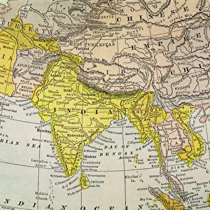
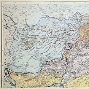
Fine Art Print : 1818, Pinkerton Map of India, Pakistan, Afghanistan, Tibet, Nepal, Sri Lanka, John Pinkerton


![]()
Fine Art Prints from Liszt Collection
1818, Pinkerton Map of India, Pakistan, Afghanistan, Tibet, Nepal, Sri Lanka, John Pinkerton
1818, Pinkerton Map of India, Pakistan, Afghanistan, Tibet, Nepal, Sri Lanka, John Pinkerton, 1758 - 1826, Scottish antiquarian, cartographer, UK
Liszt Collection of nineteenth-century engravings and images to browse and enjoy
Media ID 14004970
© Artokoloro Quint Lox Limited
1758 1826 1758 – 1826 17581826 1818 Afghanistan Cartographer John Pinkerton Nepal Pakistan Scottish Antiquarian Sri Lanka Tibet Antique Map Latitude Longitude Mappa Mundi Old Antique Plan Old Antique View Ols Antique Map Rare Old Maps Topo
20"x16" (+3" Border) Fine Art Print
Step back in time with our exquisite selection from the Media Storehouse Fine Art Prints series. This captivating piece showcases the 1818 Pinkerton Map of India, Pakistan, Afghanistan, Tibet, Nepal, and Sri Lanka. Created by renowned Scottish antiquarian and cartographer John Pinkerton in 1818, this map is a testament to historical cartography. The intricate details of the map, drawn from Pinkerton's extensive research and travels, offer a glimpse into the geographical knowledge of the time. Bring a piece of history into your home or office with this stunning Fine Art Print, perfect for history enthusiasts, cartography collectors, or anyone who appreciates the beauty of historical maps.
20x16 image printed on 26x22 Fine Art Rag Paper with 3" (76mm) white border. Our Fine Art Prints are printed on 300gsm 100% acid free, PH neutral paper with archival properties. This printing method is used by museums and art collections to exhibit photographs and art reproductions.
Our fine art prints are high-quality prints made using a paper called Photo Rag. This 100% cotton rag fibre paper is known for its exceptional image sharpness, rich colors, and high level of detail, making it a popular choice for professional photographers and artists. Photo rag paper is our clear recommendation for a fine art paper print. If you can afford to spend more on a higher quality paper, then Photo Rag is our clear recommendation for a fine art paper print.
Estimated Image Size (if not cropped) is 40.6cm x 48.2cm (16" x 19")
Estimated Product Size is 55.9cm x 66cm (22" x 26")
These are individually made so all sizes are approximate
Artwork printed orientated as per the preview above, with portrait (vertical) orientation to match the source image.
EDITORS COMMENTS
This print showcases the remarkable "1818, Pinkerton Map of India, Pakistan, Afghanistan, Tibet, Nepal, Sri Lanka" created by John Pinkerton. A Scottish antiquarian and cartographer from the late 18th to early 19th century, Pinkerton's expertise in topography and geography is evident in this exquisite piece. The map encompasses a vast expanse of land with intricate details that highlight the geographical features of the region. From the majestic peaks of the Himalayas to the sprawling plains and rivers that define these nations' borders, every contour is meticulously illustrated on this vintage artifact. With its aged appearance and historical significance, this map takes us back to an era when exploration and discovery were at their peak. It serves as a window into a world long gone yet still relevant today. The paper texture adds an extra layer of authenticity to this decorative piece. As we gaze upon this rare old map with admiration for Pinkerton's craftsmanship, we are reminded of how maps have played a crucial role in navigation throughout history. This antique treasure not only provides valuable insights into past civilizations but also sparks our curiosity about distant lands waiting to be explored. Whether you are an avid collector or simply appreciate art with historical value, this print offers a glimpse into centuries-old cartography that will surely captivate any viewer's imagination.
MADE IN THE USA
Safe Shipping with 30 Day Money Back Guarantee
FREE PERSONALISATION*
We are proud to offer a range of customisation features including Personalised Captions, Color Filters and Picture Zoom Tools
SECURE PAYMENTS
We happily accept a wide range of payment options so you can pay for the things you need in the way that is most convenient for you
* Options may vary by product and licensing agreement. Zoomed Pictures can be adjusted in the Cart.